
Table of Contents
Although Great Britain is a large island, there are thousands of significantly smaller islands that are located away from the country’s coastline – some of these are rather close to the shoreline, whereas others are tens (and even hundreds) of kilometres away. This article covers the largest of these islands, including both individual isles and archipelagos. Many of these islands are not only popular tourist attractions, but are also renowned not only within the United Kingdom, but also internationally, for their impressive coastal landscape. Although 16 islands and archipelagos are listed in this article, 12 of these are in Scotland, with three in England and one in Wales.
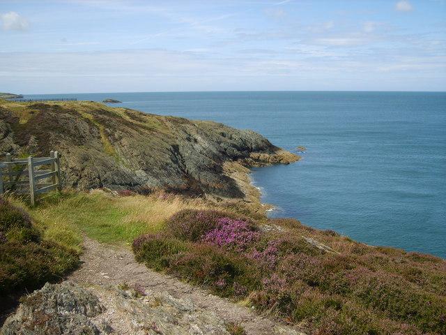
Isle of Wight, England
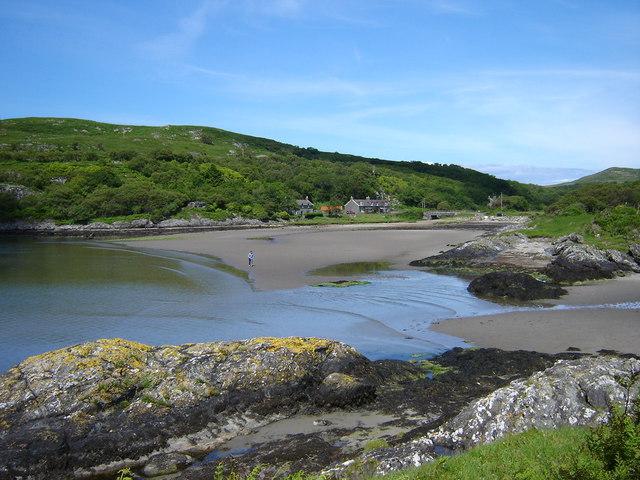
The Isle of Wight is a large island that is located between 4 and 6 km from the southern coast of England. Separated from the mainland by the Solent, it is situated to the south of Hampshire, with frequent ferry connections via the ports of Southampton and Portsmouth. It is a popular tourist destination for many British holidaymakers, owing mainly to its relatively warm southern English climate during the summer months, but also to its pleasant scenery and natural landscape.
Isle of Wight Coast Path near St Lawrence
By Michael Coppins, own work CC BY-SA 4.0, via Wikimedia Commons
Rather diamond-like in shape, with both a north side and a south side, the island has different landscape features on either of its sides. The north side of the island tends to have a gentler coastline, with sandy bays, small flooded valleys, and rolling hills sloping down to the shore. A crescent of sand arches around Colwell Bay on the north-western edge of the island, and a large beach borders the Victorian seaside resort town of Ryde, on Wight’s north-eastern edge. Other areas are renowned for their luscious and scenic coastal woodland, such as Bouldnor Copse, which gently slopes down to the water’s edge. The harbour town of Cowes sits at the most northerly extent of the island – it is split into two sections by the Medina estuary, a large flooded valley which stretches southwards for several kilometres.
The Needles, Isle of Wight, UK by Mypix, CC BY-SA 4.0, via Wikimedia Commons
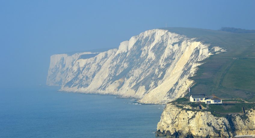
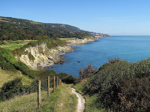
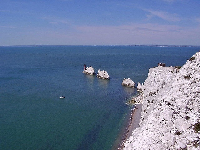
The southern side of the island, however, has more dramatic landscape features than the northern coastline. The Needles are a distinctive set of three chalk rock stacks that sit at the western end of a large chalk peninsula – a symbol of the United Kingdom, they are a large tourist attraction. Eastwards from here, a towering set of chalk cliffs runs eastwards for around 6 km. A series of large cliffs also tower over the shoreline at St. Catherine’s Point – a headland which marks the most southerly point of the island. The southern coast of the island is incredibly scenic, with highlights including the Victorian resort town of Ventnor, which is built on the hillslope that rises from the coastline. Areas of scenic woodland also cover these slopes here, such as at Luccombe Bay – a rather sheltered bay tucked beneath the 240-metre-high St. Boniface Down. The Isle of Wight’s south-western coast (around Brighstone Bay and Chale Bay) is also renown for being one of the United Kingdom’s best hotspots for fossils.
References
[1] https://www.visitisleofwight.co.uk/
[2] https://www.thebeachguide.co.uk/south-west-england/isle-of-wight/colwell-bay.htm
[3] https://www.theneedles.co.uk/
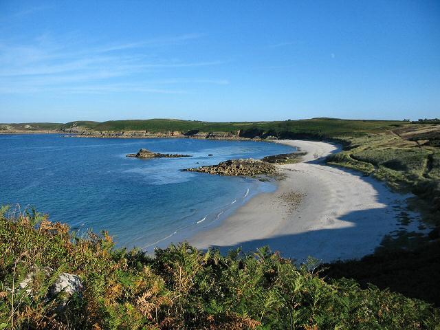
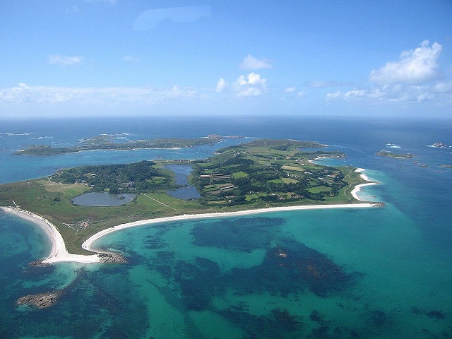
Isles of Scilly, England
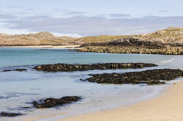
The Isles of Scilly is a small archipelago that is located around 40km from the south-western tip of the Cornwall peninsula. Over 140 islands make up Scilly, and although many of the islands are simply rocks poking above the waves of the Atlantic Ocean, several of them are large enough to be inhabited, with small villages and fishing hamlets scattered around the isles. The largest of the Scillies are covered in serene patchwork fields and pockets of woodland, while the coastline includes some beautiful sandy coves.
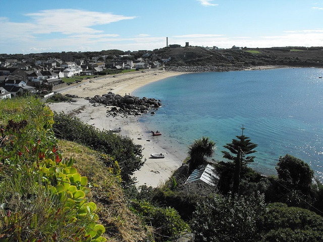
The 3.5-kilometre-length St. Mary’s island is the largest of the archipelago. The picturesque fishing village of Hugh Town is located to the west of the isle, with its beautiful white-painted buildings sandwiched between two wide sandy bays. Beaches are commonplace on the island, including Porthcressa Beach, Porth Hellick and Bar Point – each with its own strip of glorious white sand. Although cliffs are generally rather low on the Scillies, the shoreline is also quite rocky in places. This is the case with Peninnis Head, where rocks and boulders litter both the shore and the steep slope up onto the promontory.
Other islands are just as peaceful and tranquil – with a lower population than St. Mary’s, the island of St. Agnes contains a wilder landscape, with numerous rocky coves and beaches filled with sand. Tresco lies just to the north of St. Mary’s, and is well-known for its beautiful fishing hamlet of New Grimsby, and the luscious botanic garden of Tresco Abbey, which is packed with a myriad of exotic plant and tree species. Tresco is also surrounded with sandy beaches, such the one that arches around Pentle Bay on the eastern side of the isle. The island of St. Martin’s also includes many small, rocky bays, as well as the rugged St. Martin’s Head, which stands almost 50 metres above the crashing waves below.
Neil Adams, CC BY-SA 4.0, via Wikimedia Commons
[1] https://www.visitislesofscilly.com/
[2] https://www.visitislesofscilly.com/explore/st-marys
[3] https://www.islesofscilly-travel.co.uk/2017/06/5-top-beaches-on-the-isles-of-scilly/
[4] https://www.tresco.co.uk/enjoying/abbey-garden
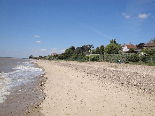
Mersea Island, England
Separated from the coast of Essex by a small tidal channel, Mersea Island is a 7-kilometre-long isle that faces out towards the North Sea on its southern side. With several sandy beaches, the town of West Mersea, and a decent-sized patch of marshland, Mersea Island is surrounded by a few interesting features. Outside of the peak tourist season, it is a rather quiet and laid-back island that is located within a rural setting.
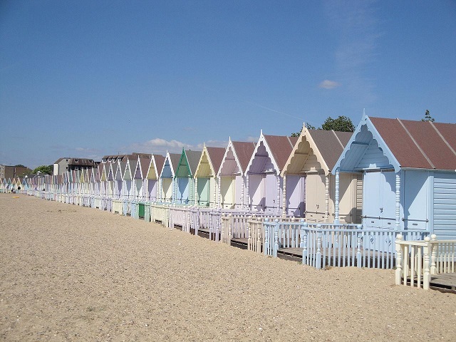
Characterised by a sliver of golden sand, West Mersea Beach is one of the largest sandy shores on the island. Stretching for around 3 km along the southern side of the island, part of it is bordered with a row of beach huts painted in nice pastel colours. In addition, Fen Farm Beach is also worth visiting – situated on the south-eastern portion of Mersea Island, it is located in a far more rural setting. A nature reserve and areas of marsh flats make up the coastline to the north of Fen Farm.
The aforementioned town of West Mersea sprawls out across the south-west of the island. On the isle’s western coast lies a small promenade and marina, as well as various pubs and restaurants. However, unlike many coastal port towns, many of the buildings here are relatively new, having been built over the past few decades. Away from West Mersea, the island is covered in farmland, with the occasional farmhouse or small village. A causeway – upon which rests the B1025 road – links the mainland from Mersea’s northern side. A large channel filled with marshland and mudflats separates the two, with the tide cutting off the island from the Essex mainland twice a day. The highest of tides even cover the causeway, making Mersea feel even more like an island at times.
Anglesey, Wales
The Isle of Anglesey is located just off from the north-west coast of Wales. Separated from the mainland by the relatively narrow Menai Strait, which varies between 0.4 and 1.1 km in width, Anglesey is easily accessed by two bridges, one of which includes a railway line and the A55 North Wales Expressway, a vital link between the busy ferry port of Holyhead and the rest of Great Britain.
It is no surprise that Anglesey is such a popular tourist destination, as the island is packed with a variety of great coastal scenery and attractions. A craggy coastline, that is characterised by headlands and sheltered sandy coves, surrounds much of the island Particularly beautiful coves and bays including Traeth Benllech, Traeth Mawr and Trearddur Bay. The Blue Flag beach at Traeth Llanddwyn is also incredibly scenic, consisting of a vast expanse of sand backed by a row of rolling sand dunes – on the contrary, large cliffs stand just to the west of Holy Mountain, towering above the crashing waves below.
The island also includes patches of tranquil coastal woodland, including Penrhos Coastal Park, a low-lying deciduous wood just to the east of Holyhead, and the vast Newborough Forest, which borders Traeth Llanddwyn beach. Anglesey also contains historical features, including the Medieval-built Beaumaris Castle, which sits on the eastern side of the island, overlooking the Menai Strait and the Welsh mainland. Although the fortress was started but never completed, its incredibly large size and near-symmetrical shape make the castle a rather special tourist attraction.
References
[1] https://cadw.gov.wales/visit/places-to-visit/beaumaris-castle
Arran, Scotland
Located 20 km from the western Ayrshire coastline, and around 60 km to the south-west of Glasgow, Arran is a beautiful island located within the Firth of Clyde. With only a ferry connection to the Scottish mainland, the island has a rather wild landscape, Arran is definitely worth visiting for a peaceful getaway. Around much of the island, the rolling landscape slopes down to the coast from the peaks within Arran’s interior – these are often filled with luscious green woodland, or with a beautiful patchwork of green fields. The coastline offers incredible panoramic views – not just up and down the coast of Arran, but also across the water to the Kintyre Peninsula, which lies 6 km to the eastern side of the island.
In terms of coastal features, impressive headlands are scattered along Arran’s coastline, such as Clauchlands Point and Newton Point. Drumadoon Point, located on the eastern side of the island, consists of impressive columnal basalt cliffs that overlook the sea, and the remains of an ancient wall on the western Arran-facing side – this was once used as an Iron Age hillfort. Although sand is often in short supply on the island, the wild rocky beaches only add to Arran’s wild and rugged nature. However, sand lines the shoreline at several points around the island, such as at Torrylinn Beach and Blackwaterfoot.
Several villages line the coastline at various points along the shore, including Lamlash – tucked away along the side of the bay of the same name, and Blackwaterfoot – with its grey cottages overlooking the Kintyre Peninsula. Lochranza, a small coastal village tucked away at the foot of a glacially-carved valley, also contains a derelict castle and a whisky distillery. More info about Arran here:
References
[1] https://www.visitscotland.com/destinations-maps/arran/
[2] https://ancientmonuments.uk/123114-the-doonfort-and-standing-stones-ardrossan-and-arran-ward#.YFN0F6_7SUk
[3] https://www.walkhighlands.co.uk/arran/drumadoon-point.shtml
[4] https://www.thearranteam.co.uk/discover#:~:text=Torrylinn%20Beach%2C%20via%20the%20footpath,to%20Kings%20Cave%20and%20Machrie.
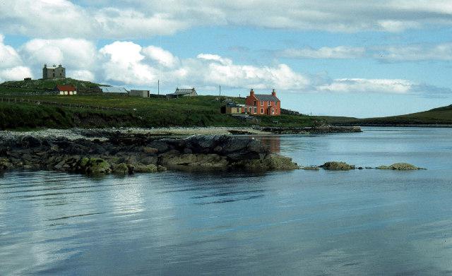
Bute, Scotland
The Isle of Bute is located in the northern part of the Firth of Clyde, with a 500-metre-wide strait named the Kyles of Bute separating Bute’s north coast from the mainland – the Cowal peninsula. The island consists of rolling hills, with the coastline around the northern third of the island consisting of grassland and coniferous woodland plantations that slope upwards from the coast. The shoreline is generally rather wild and rocky, with a lack of buildings or villages on this part of the island. Small coves are interspersed with intermittent headlands, the largest of which is Buttock Point, Bute’s most northerly point. From this side of the island, the views across the Kyles of Bute are spectacular, with the peaks of the Cowal peninsula rising from the water’s edge – however, access to this side of the island is not easy, with the closest public road being the A886, which takes traffic from one of the island’s ferry terminals into Bute’s interior.
East Coast of Bute by Tim Niblett, CC BY 2.0, via Wikimedia Commons
.jpg)
The rest of the island is less wild, with seaside villages sprinkled along the coast amid cultivated fields that often gently slope down to the water’s edge. Bays and headlands are common features, with the rocky Ardcalpsie Point on Bute’s west coast, and the large cliffs of Garroch Head which makes up the island’s most southerly point. Wide sandy bays are also found on Bute, including Ettrick Bay and Kilchattan Bay. Small picturesque villages also line small sections of the coast – these include Rothesay, a Victorian seaside resort village with a Medieval castle, and the village of Kilchattan Bay, with a row of cottages and Victorian-era villages that overlook the bay of the same name.
References
[1] https://www.wildaboutargyll.co.uk/whats-new/blogs/the-beautiful-beaches-of-bute/
[2] https://www.visitscotland.com/info/towns-villages/rothesay-p234971
Islay, Scotland
The Isle of Islay is the southernmost island of the Inner Hebrides, which is the name given to an island chain that is located just off from the western coast of Scotland. The Kintyre peninsula is the closest section of mainland to the island – this is located around 25 km to the east of Islay. However, the large island of Jura is located almost directly to the north-west of Islay, separated by an 800-metre-wide stretch of water called the Sound of Islay.
Dennis Allen / Port nan Gallan, on the Mull of Oa, Isle of Islay
The island itself is around 35km in length from north-to-south, and around 25km from its most westerly to easterly points. Although the coastline is characterised by many sections of rugged headlands, and a coastline lined with rocks and pebbles, several large sandy bays also cover parts of Islay’s shore. Apart from several seaside villages scattered along the coastline, much of the coastal landscape is wild and uninhabited, and is therefore incredibly peaceful and serene. Huge cliffs tower above parts of the coastline, such as at McArthur’s Head on the western coast of the island, and at the tip of the Mull of Oa headland, located on the south-western side of Islay. The north-western coast is also characterised by tall, rugged cliffs, and many sheltered coves.
However, the south-eastern side of the island is rather low-lying, with pockets of deciduous woodland bordering the coastline, itself interspersed with small and sheltered coves. Several large expanses of sand also form part of the island’s shoreline, such as at Laggan Bay, and sections of sand dunes around Loch Gruinart, situated at the north of Islay. In addition, notable examples of beautiful coastal villages include Bowmore, which is known for its whisky distillery, and Portnahaven, Port Ellen and Bunnahabhain, each with its own interesting history.
References
[1] https://www.islayinfo.com/
[2] https://www.visitscotland.com/info/towns-villages/bowmore-p235271
Jura, Scotland
Situated around 8 km off from the western coast of the Scottish mainland, the long and narrow-shaped island of Jura is characterised by its rolling mountains and moorland landscape. The island is incredibly wild and untamed, with a permanent population of only 200 people, although parts of Jura can be fairly popular with tourists during the summer. Nevertheless, the island is worth visiting for its great coastal landscape, including sandy coves, rugged cliffs, and a geological feature known as a ‘raised beach’.
Although the majority of the coastline around Jura is rather wild and untouched, the southern and eastern sides show subtle signs of human activity, with the occasional farmhouse or hamlet sprinkled close to the shore. The A846 road links the eastern side of Jura with the small village of Craighouse, and to the ferry port, which links Jura to both Islay and the Scottish mainland. As expected, the coastline along the western side of the island generally consists of the usual ruggedness one would associate with a Scottish isle, with highlights including sandy beaches at Loch na Mile and Lowlandman’s Bay, both which are separated by the impressive Cnocan Soilleir headland. The further north one travels, the coast becomes even more remote, and great views can be seen of the coastline and the Scottish mainland from seaside hills such as Cnoc à Chùirn Mhòir. Pockets of woodland also line the coastline here.
However, the western side of Jura is even more wild, with many coves and sheltered sandy bays (such as Corpach Bay), large headlands (for example Rubha an t-Sàilein) and numerous caves. However, the western side of the island is most famous for its raised beaches – some of the most impressive examples of this feature in western Europe. These landforms, which are raised more than 5 metres above the sea level, were formed at the end of the last Ice Age, due to a temporarily higher sea level.
References
[1] https://www.visitscotland.com/destinations-maps/isle-jura/
[2] http://www.hill-bagging.co.uk/mountaindetails.php?qu=S&rf=11508&st=cld
[3] https://www.geolsoc.org.uk/GeositesTarbert
Isle of Mull, Scotland
Making up the second largest of the Inner Hebrides, the Isle of Mull is separated from the Scottish mainland by a 2-kilometre-wide strait named the Sound of Mull. The island’s coastline island is rather varied, with tall headlands, towering cliffs, coves, sandy bays and coastal woodland all bordering the shoreline for at least some of its length.
The island’s north-eastern side is relatively gentle compared to Mull’s other coastlines – although the shoreline is rather rocky, the cliffs here tend to be rather low. Inlets such as Salen Bay and Fishnish Bay are fairly easy to access – the latter of these is bordered on its eastern side by a low forest-covered headland named Fishnish Point. In the island’s largest village – Tobermory – distinctive brightly-painted seaside cottages overlook the Sound of Mull.
However, Mull’s southern and western extremities are much wilder, consisting of extremely impressive natural features formed by complex geological events spanning more than 2 billion years. The southern side of the island is characterised by sections of towering cliffs – these are not only renowned for their height, by also for their intermittent pentagonal and hexagonal columns, which were formed by the cooling and contraction of lava. This is particularly impressive along the coastline between Carsaig Bay and Malcolm’s Point – the latter of which also hosts the Carsaig Arches, spectacular natural arches formed by wave-induced erosion. On the Ardmeanach peninsula, located on the western side of Mull, equally impressive cliffs tower over the rocky shoreline below – waterfalls tumble down the 300-metre-high sides, and the fossilised impression of a 12-metre-high tree has been preserved in the cliffs at sea level. Caves are also found in plentiful numbers within the cliffs, such as McKinnon’s Cave, tucked away at the back of a sheltered tidal inlet.
 Calgary Bay, Isle of Mull by David Hambidge, CC BY-SA 2.0, via Wikimedia Commons
Cliffs and headlands also characterise the north-western coast of Mull, such as Caliach Point. However, several sandy beaches can also be found here. Calgary Bay contains an arc of beautiful white sand and turquoise water – one would typically find these at a Mediterranean beach. Due to its remote location, the beach is rather tranquil and serene.
References
[1] https://www.visitscotland.com/destinations-maps/isle-mull/
[2] https://www.isle-of-mull.net/attractions/geology/
[3] https://www.isle-of-mull.net/attractions/geology/carsaig-arches/
[4] https://www.isle-of-mull.net/attractions/geology/fossil-tree/
[5] https://www.isle-of-mull.net/attractions/geology/mackinnons-cave/
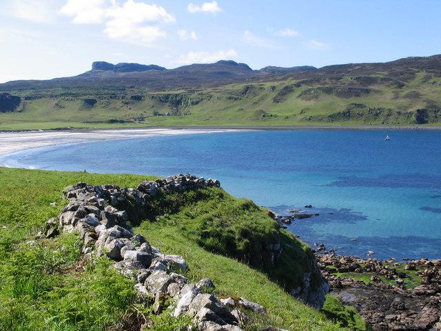
The Small Isles, Scotland
Making up part of the Inner Hebrides, the Small Isles is an archipelago located around 12 km to the south of the Isle of Skye. The Small Isles cover a much smaller land area than Skye to the north, and consist of four main islands – Rùm, Canna, Eigg and Muck. They are rather remote and wild islands, with a population of roughly 150 people.
Russel Wills / Thrift growing above beach at Samhnan Insir
Measuring around 10 km by 10 km across, Rùm is the largest of the islands. It has a dramatic coastal landscape, with towering cliffs a common feature (particularly on its southern and western edges), mainly due to the various steep and craggy mountain peaks which make up much of the island. Sheltered rocky coves, such as Wreck Bay and Guirdil Bay, shoulder their way in between steep coastal slopes, often where streams tumble down from the island’s interior. The north and eastern sides tend to be slightly less dramatic, with a few sandy bays. The largest of these is Loch Scresort, which is overlooked by the foreboding Kinloch Castle.
Wendy Bradley / Coast near Laig Bay
The most north-westerly of the Small Isles, Canna is surrounded with tall, basalt cliffs that are interspersed with small rocky bays and inlets. Eigg is situated to the south-east of Rùm – the impressive escarpment of Beinn Bhuidhe dominates the northern half of the island, whereas the dramatic An Sgùrr towers over the southern portion. As expected, the coastline is incredibly rugged and rocky, with sections of impressive cliffs – however, sandy bays exist on both the southern and north-western parts of the island. Muck is the most southern of the small isles, and also has a rather rocky coastline.
References
[1] https://www.visitscotland.com/info/towns-villages/small-isles-eigg-rum-muck-canna-p236491
Coll and Tiree, Scotland
Coll and Tiree are two low-lying islands that are located around 15 km to the west of the Isle of Mull. A part of the Inner Hebrides island chain, Coll and Tiree are both between 15 and 20 km in length, and are separated by a small channel named the Gunna Sound. Each island contains its fair share of lovely sandy beaches separated by rugged headlands and rocky promontories. However, Tiree contains more sandy coves, whereas Coll is more wild and rugged.
The landscape of Tiree is rather flat, with a vast area of grassland covering the vast majority of the island. In contrast to this, several rugged hills protrude above the rest of the landscape – these include Carnan Mor and Beinn Hough. On the southern side of Tiree, over a kilometre of beautiful white sand makes up Crossopol beach. Other great beaches include Hough Bay and Vaul Bay, both of which are quiet and peaceful, and are backed by a system of lush, grass-covered sand dunes. Although cliffs are rare on Tiree, there are headlands which protrude out into the sea on the south-western side of the island – in addition, although the rest of the coastline is rather low-lying, the shoreline around the eastern half of the island is dominated by rock formations.
Coll is more rugged, with less sandy beaches. Despite this, there are large sandy beaches at Feall Bay and Bàgh an Trailleich, both of which are backed by impressive sand dunes. Tidal inlets on the southern side of the island – such as Loch Breachachna and Loch Eatharna – also unveil a decent sliver of sand during low tide. However, Coll’s eastern and northern sides are incredibly rugged, with rocky hillsides sloping down into the sea. Although both islands are rather remote, this part of Coll is particularly wild, with very few signs of human activity along this part of the coastline.
References
[1] https://www.walkhighlands.co.uk/islands/
[2] https://outaboutscotland.com/the-best-beaches-on-tiree/
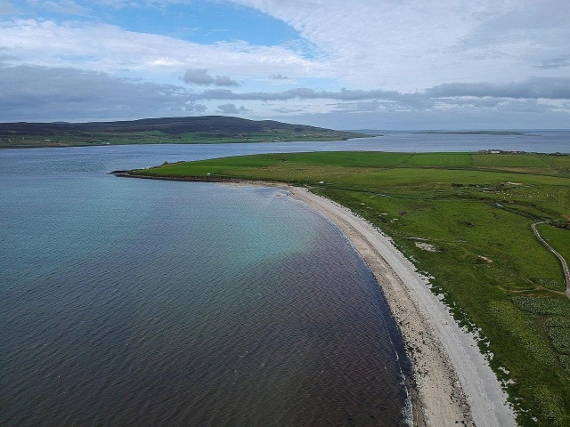
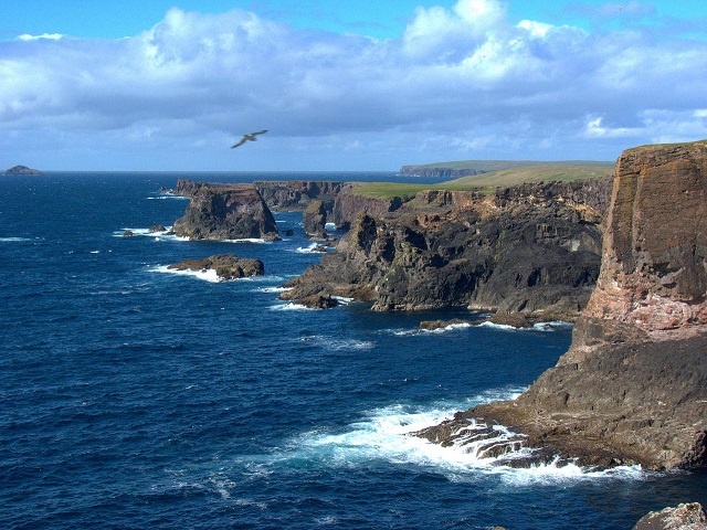
Orkney Islands
Located around 16 km to the north of John O’Groats, the Orkneys is an archipelago of roughly 70 islands, including the relatively large and well-known Mainland island, but also Hoy, Burray, Rousay and Sanday. The coastline around the archipelago is mainland characterised by a rocky shoreline, with frequent pebble beaches. Cliffs, coves, bays and headlands are rather common features, but stretches of sandy beaches are also sprinkled along the Orkney coastline. Parts of the coast are also rather flat, and in some places, fields border the shoreline. Although the Orkneys can be quite popular with visitors during the summer months, they are rather quiet most of the year, and are known for their peacefulness.
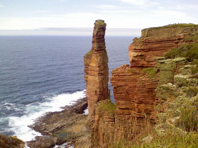
Although cliffs are a frequent feature around many of the islands, they are particularly striking along the western coast of Hoy, where they tower above the roaring waves. The natural beauty is astounding, with streams tumbling down the cliffs, forming stretches of waterfalls. The island is also famous for the Old Man of Hoy – a towering, yet incredibly narrow, rock stack. Furthermore, the colossal 351-metre-high cliffs at Saint John’s Head are amongst the tallest in Britain. The western and northern sides of the Mainland isle are also packed with rugged inlets, sheltered bays and headlands. Marwick Head offers incredible views of the coastline to the south and east, and the impressive Hole O’Row natural arch lies just to the south of the Bay of Skaill.
 Sands of Evie from above, with the island Rousay in the background by
Matthew Prior – Own work, CC BY-SA 4.0, via Wikimedia Commons
Although cliffs and rocks dominate the coastline around the majority of the islands, some sandy beaches also exist. The rather appropriately-named Sanday island contains many fine and extensive sand beaches, such as Tres Ness and Lopness, which are interspersed by low-lying rocky headlands. A similar feature is also seen on the north coast of the Mainland island, where several large sandy bays are separated by low headlands.
References
[1] https://www.northlinkferries.co.uk/orkney-blog/ten-further-hidden-gems-of-orkney/
[2] https://www.visitscotland.com/info/towns-villages/hoy-graemsay-p238351
[3] https://www.orkney.com/
Outer Hebrides
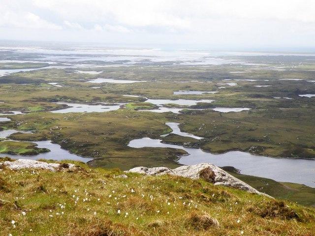
The Outer Hebrides is a chain of islands located around 50-100 km away from the northern half of western Scotland. Stretching for roughly 210 km from Barra Head in the south, to the Butt of Lewis in the north, this large archipelago chain consists of over 100 islands. The largest (and most populous) island of this chain is named Lewis-and-Harris – this makes up the northern half of the Outer Hebrides, and is surrounded by many smaller islands. The southern half of the chain consists of numerous islands – the largest of these are North Uist, South Uist, and Barra Island.
Northern Half – Lewis and Harris
Although this is one island, it is frequently referred to with two names: Lewis for the flatter northern three-quarters of the isle, and Harris for the significantly more mountainous southern quarter. The coastline reflects this difference in the terrain – dramatic fjord inlets are situated on the southern side of the island, whereas Lewis’s coastline is mainly characterised by rugged headlands, bays and lower cliffs. Around large sections of the island, the coast is incredibly wild. This is particularly true around Loch Claidh and Loch Seaforth, where a lack of human habitation and activity makes for an incredible natural landscape. The coast along the Harris’s south-eastern edge is also rather spectacular – a rocky coastline is backed by an incredible landscape of rolling hills littered with large rocky outcrops. The north-western coast of Harris is marked by rocky peaks that tower over the sea underneath – the Hebridean island of Scarp is located close to the coastline here.
As mentioned, the Lewis section of the island is less dramatic, but still rather beautiful and spectacular in its own way. The coastline is – as expected with the Outer Hebrides – rather rugged, with inlets and rocky islands rather commonplace. Cliffs are a frequent feature, often forming headland promontories – the most notable of these being Tiumpan Head, Tolsta Head and the Butt of Lewis. However, sandy bays are also sprinkled along the coast, including the expansive Uig Sands, which is located at the head of a rocky bay, and Tolsta Beach, with its wide golden sand arching around the bay.
Tolsta Beach by ian ( windy_ ), CC BY 2.0, via Wikimedia Commons
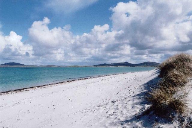
Southern Half – North Uist, Benbecula, South Uist and Barra Island
The southern half of the Outer Hebrides is made up by many islands, the largest of which are listed in the title. The Uists, which are separated by Benbecula, generally consist of an incredibly rugged eastern side, where the peaks of hills and mountains intermittently rise up from the sea, often dropping down steeply to the rocky shoreline. As a result of being covered by an ice sheet during much of the last Ice Age, the coastline along North Uist and Benbecula is marked by a myriad of small rocky islands sitting just off of the Uist mainland. The coast meanders immensely, with countless lochs and inlets stretching inland, such as Loch Nam Madach and Loch Euphort. Headlands are also fairly commonplace. On South Uist, however, the ruggedness intensifies, with peaks such as the 620-metre-high Beinn Mhòr rising high above the coastline, only adding to the incredibly wild and dramatic Outer Hebridean landscape.
North Uist near Solas by Scot Tares, CC BY-SA 2.0, via Wikimedia Commons
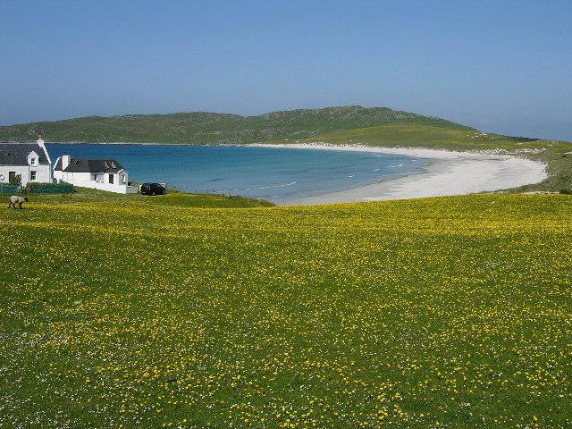
However, the northern and western side of the Uists is characterised by a rather different landscape – a string of beautiful beaches stretches along much of the coastline. Each beach is filled with white sand that nicely contrasts with the turquoise-coloured sea water. Particularly beautiful beaches include Clachan Beach (or Traigh Hornais), located on North Uist’s northern coast, and Frobost Beach, situated on South Uist. Many expansive tidal inlets feature on this side of the Uists, only adding to the beautiful landscape of the archipelago.
To the south of the Uists lie other islands, the largest of which is Barra. Made up of large peaks which rise up majestically from the rocky shoreline, Barra is also incredibly scenic. A few beaches are also sprinkled around this island, and are often backed by small sand dune systems.
References
[1] https://www.visitscotland.com/info/towns-villages/north-uist-p244271
[2] https://www.walkhighlands.co.uk/news/our-pick-scotlands-best-island-beaches/
[3] https://www.visitouterhebrides.co.uk/see-and-do/frobost-beach-and-machair-p522981
Shetland Islands
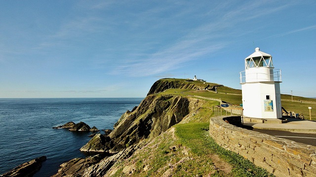
The Shetland Islands are a string of around 100 islands, located around 170 km to the north-west of John O’Groats. The largest island – named ‘Mainland’ – occupies just over half of the Shetland Islands’ land area, with other large islands including Yell and Unst.
Mainland
This island consists of a large 40-km-long peninsula that stretches down from the port town of Lerwick, as well as a vast western, northern and eastern coast that meanders around many large lochs (named ‘voes’), as well as deep inlets that have been cut into the cliff face (called ‘geos’). Each loch is separated by other peninsulas, such as Eshaness. The lochs include Weirsdale Voe, Gruting Voe and Olna Firth – around these, large grass-covered hills rise up from the shore. Large inlets, such as Calder’s Geo on the western side of the Eshaness peninsula, are also a fairly common land feature, formed by waves carving into the rock over thousands of years. A few natural arches are located around the island, such as at Dore Holm.
Chris Combe from York, UK, CC BY 2.0, via Wikimedia Commons
.jpg)
The coast itself is rather rugged – rocky cliffs, headlands and bays make up the vast majority of the isle’s coastline. Sumburgh Head is one of these headlands – it is a rocky promontory that marks the southern tip of the Mainland island, whereas the 283-metre-high Fitful Head also rises up from the waves a few kilometres to the north-west of Sumburgh Head. Another spectacular headland is Banks Head, which overlooks the Bay of Deepdale – looking southwards from the top of this headland, the rugged coastline meanders into the distance, its impressive rock stacks only metres from the shoreline.
Sumburgh Head by Ronnie Robertson, CC BY-SA 2.0, via Wikimedia Commons
Although sandy beaches are rare, some of these also exist on the Mainland island. These include West Voe Beach, with its white sand and dunes. Other beaches include Tresta Beach and the Sands of Sound – the latter located just to the south of Lerwick, which is a traditional fishing port situated on the eastern coast of the island.
References
[1] https://www.shetland.org/visit/plan/areas/south-mainland
[2] https://www.shetland.org/visit/do/wildlife/beaches
[3] https://www.geograph.org.uk/photo/102380
Yell and Unst
To the north-west of the Mainland Island are two smaller – but still relatively large – islands named Yell and Unst. Large cliffs surround much of both islands – these often meander around headlands, geos, rocky bays, and the occasional sandy beach. The cliffs on the western coasts of both Yell and Unst are particularly wild and interesting – for example, the 100-metre-tall cliffs close to Rulkies Hill provide great views of rock stacks, a headland and a natural arch. The North Neaps and Gloup Ness coast, both on the northern edge of Unst, also provide a great scenery that is packed with rocky headlands, a few natural arches, and a sandy beach named the Sands of Breckon. The eastern side of Yell also contains a similar landscape, including the Horse of Burravoe – a superb headland that contains two natural arches adjacent to one other. Several sandy bays are also located on this side of the island, including the beautiful Gossabrough Beach.
Mike Pennington / View north from Toolie, Hermaness
Unst also contains its fair share of ruggedness, with rock stacks and rocky shores common features along the western side of the island. The headland at Herma Ness marks the most northerly point of the Shetland Islands – and great views of the coastal landscape can be seen from the top of the promontory. Several small rocky islands are located just to the north of Herma Ness – one of these, named Out Stack, marks the most northerly extent of the United Kingdom. The eastern side of Unst tends to be less rocky – although the coastline is still rather rugged, some bays are also located within the cliff-dominated landscape. These include Nor Wick, Harold’s Wick and Sand Wick – the latter also has a sandy beach.
Burravoe, Unst by Stephen McKay, CC BY-SA 2.0, via Wikimedia Commons
References
[1] https://www.northlinkferries.co.uk/shetland-blog/great-places-to-go-in-yell/
[2] https://www.mudandroutes.com/summit/rulkies-hill/
[3] https://www.britainexpress.com/photos.htm?attraction=1133
[4] https://www.shetland.org/visit/do/outdoors/cycle/mid-yell-south-yell
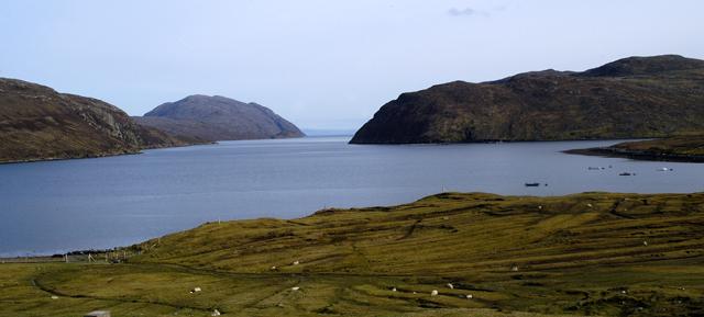
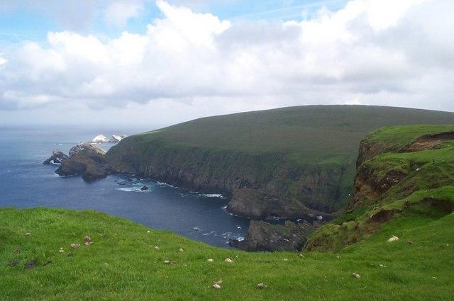
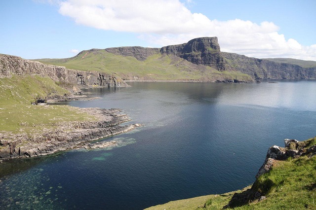
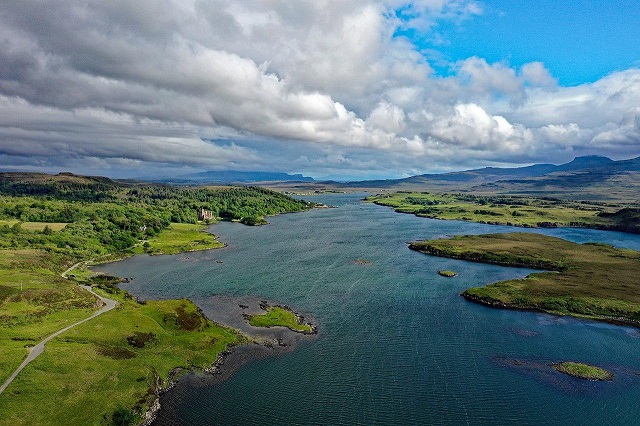
The Isle of Skye
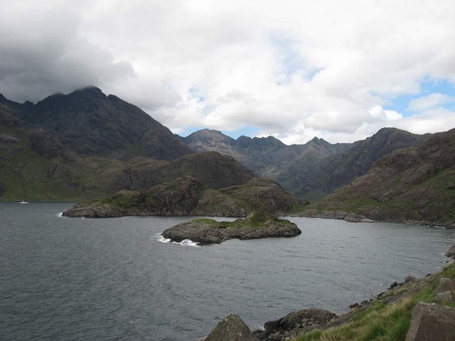
The largest of the Inner Hebrides, the Isle of Skye is around 80 km in length from east to west, yet its eastern tip is situated only 500 metres away from the Scottish mainland. Like all of western Scotland, the Isle of Skye incredibly remarkable for its scenery, with a picture-postcard landscape of towering mountains, wide glens, and numerous fjords. The coastline includes large peninsulas, mountains dramatically sloping down to the shoreline, and many wild cliff landscapes that are interspersed with quiet bays. It is therefore no surprise that Skye is a popular tourist destination both within the United Kingdom and internationally – however, despite a large influx of tourists during the summer months, much of the island is rather wild and remote.
Over Loch Eishort and Loch Slapin
by Paul Lucas from Leicestershire, UK, CC BY 2.0, via Wikimedia Commons
.jpg)
Much of the Skye coastline consists of cliffs that tower up above the crashing waves below, from which incredible views of the coastal landscape can be seen. For example, at Waterstein head (located on the Duirinish peninsula, on the western side of the island), cliffs rise almost 300 metres in height above the waves. The coastline down to Idrigill Point, which marks the southern tip of the same peninsula, consists of similarly dramatic cliff-dominated scenery. The Minginish and Trotternish peninsulas also consist of a wild coastal landscape, with an incredibly high cliff escarpment running along the eastern edge of the latter peninsula. Scenic viewpoints of the coast are visible from the southern section of the Trotternish peninsula – these are easily accessible from the A855 road.
Moonen Bay and Waterstein Head by Nessy-Pic, CC BY-SA 3.0, via Wikimedia Commons
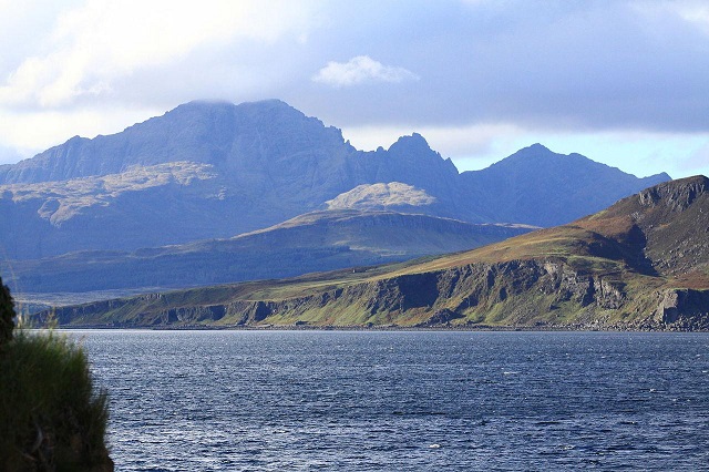
On the southern side of the island, the high peaks of the Cuillin Hills rise up majestically from the shoreline, the grey and barren peaks towering over the lochs below.
Cuillin Hills by I, Pcfloor, CC BY-SA 3.0, via Wikimedia Commons
The same is also found on the eastern edge of the island, although the slopes here are covered in conifer woodlands, further enhancing the scenery. Fjords are also commonplace on Skye, and include Loch Eishort and Loch Ainort. However, some sections of the coastline are less dramatic, with large bays bordered by relatively flat areas of grassland. At the head of Loch Dunvegan, for example, several patches of sand make up the shore. However, a quiet and sheltered sandy beach is also located at the hamlet of Culnamean – located at the head of Loch Brittle, the beach is overshadowed by the Cuillin Hills to the east, only adding to the serenity of the area.
Loch Dunvegan, Isle of Skye
by PaulT (Gunther Tschuch), CC BY-SA 4.0, via Wikimedia Commons
References
[1] https://www.isleofskye.com/
[2] https://www.walkhighlands.co.uk/skye/watersteinhead.shtml