
Table of Contents
The coastline of the United Kingdom is one of the country’s most prominent features, having contributed greatly to British heritage and culture. The UK’s maritime exploits in past centuries have been significant in regards to trade, transport and war, and lighthouses together with their keepers have played a critical role in ensuring the safety of ships throughout.
There are more than 250 functioning lighthouses dotted around the British Isles, and many more whose lights once shone but have since burnt out. Each one is a little different from the last and has a unique story to tell. This makes them incredibly interesting places to visit or learn about, especially as many can be found in spectacular locations. Here, we’ve picked out 100 of the UK’s most outstanding and famous lighthouses, notable either for their history, their location, their appearance or a combination of all three.
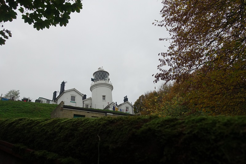
Dungeness Lighthouse, Kent
The first of our featured British lighthouses is Dungeness Lighthouse, an active lighthouse located on the Dungeness Headland in Kent. This headland is largely formed of shingle beach, which protects the low-lying Romney Marsh behind. In total, there have been 5 lighthouses at Dungeness over the years, mainly due to the constant changes in the shingle beach. The gradual accumulation of shingle on the eastern side of the headland kept leaving each lighthouse further and further from the shore, meaning new ones needed to be built.
The first lighthouse at Dungeness was built in 1615, which was replaced just twenty years later by Lamplough’s Tower. These early lighthouses used coal fires for illumination, and there were many complaints from sailors at the time who thought the lights were not good enough to aid navigation.
That all changed in 1792, when engineer Samuel Wyatt constructed a 35 metre tall lighthouse whose light was fuelled by oil. This lighthouse remained active for over 100 years and was the very first lighthouse to be permanently illuminated by an electric light, a decision made by Michael Faraday. The electric light was relatively unsuccessful however, as it proved to be unreliable and dazzled many sailors due to the relative low level of the lighthouse in relation to the sea. The tower was eventually demolished in 1904.
Another lighthouse – the ‘Old’ Dungeness Lighthouse – soon followed. This one still stands and is a popular visitor attraction, now located about 500 metres from the high tide mark.
Dungeness Lighthouse as it is seen today became operational in 1961, making it one of the most modern lighthouses in the UK and the first major lighthouse to be built in Britain in fifty years. Opened by HRH The Duke of Gloucester, it was the first lighthouse to be fitted with a xenon electric arc lamp as a source of illumination, though this new technology did not prove to be very effective.
The tower of Dungeness Lighthouse stands at 43 metres (141 feet) tall, rising from a white concrete base. It has large black and white bands and is a Grade II* Listed Building, with a light which can be seen 21 nautical miles away. It is also fitted with an electronic foghorn, to help ward off ships from the coast when visibility is poor.
South Foreland Lighthouse, Kent
South Foreland Lighthouse is a decommissioned Victorian lighthouse located in South Foreland – a high chalk headland on the Kent coast which forms part of Dover’s famous white cliffs. The waters off the coast here in the English Channel are home to the infamous Goodwin Sands, a large sand bank which lies hidden beneath the waves for most of the time. As a result, the waters are treacherous for sailing and many vessels have met their demise here over the years.
Local people first took to warning ships by way of hanging lanterns on the cliffs of South Foreland, as early as in 1367. Later, a pair of rudimentary lighthouses were constructed, one on the site where the current South Foreland Lighthouse now stands and one further down the cliff to the east. The two lighthouses were designed to work in tandem. Sailors lined the two lights up and knew to steer safely past the Goodwin Sands when the upper light shone directly above the lower light.
Both lighthouses remain to this day, and it was in 1843 that the current South Foreland Lighthouse (the upper of the two lighthouses) took its current shape.
The project was overseen by architect and engineer James Walker, who designed the lighthouse to be octagonal in shape and 21 metres (69 feet) tall. It is notable for being the first lighthouse to have an electric light, thanks to the works of the famous scientist Michael Faraday. Though this was only installed in the lighthouse on a temporary basis. The lighthouse was also used by Guglielmo Marconi for his pioneering experiments sending radio transmissions.
Around the same time that the current lighthouse was constructed, two keepers’ cottages were also built at its base. These housed the lighthouse keepers and their families, allowing them to stay on site. The lighthouse keepers remained in control of the light at South Foreland throughout the first half of the 20th century, even as modernisation helped bring a degree of automation.
However, in 1969 the lighthouse became fully automated and from that time onwards only required routine maintenance. Twenty years later, the light was closed down, with a view that modern navigational aids in ships had made the lighthouse obsolete. It was then taken over by the National Trust and was opened to the public, with the site making for a spectacular destination with great views out across the English Channel to the French coast.
North Foreland Lighthouse, Kent
North Foreland Lighthouse is an active lighthouse located on the Isle of Thanet, on the North Foreland headland. It was built in 1691 to aid the navigation of ships along the Kent coastline.
It is thought that some form of light was exhibited from North Foreland as early as 1499. The first structure resembling a lighthouse wasn’t built until 1636, when Sir John Meldrum was granted a patent from King Charles I to maintain lighthouses on both North Foreland and South Foreland. The light at North Foreland consisted of a simple structure topped by a coal-fired brazier, though it burned down in 1683.
After a few years of ships relying on a rather ineffective single candle within a lantern, a new lighthouse – the current one – was built in 1691. The tower was originally 12 metres tall and the light was produced by a coal fire within an iron grate. Ownership of the lighthouse passed to the Trustees of Greenwich Hospital in 1719, with some dues being used for the maintenance of the hospital.
At the same time, the coal fire was enclosed in a glazed lantern, however this reduced the strength of the fire and numerous shipwrecks occurred on the sandbanks off the North Foreland coast. As a result, there were a great many complaints from sailors, and the lantern was eventually removed.
A number of improvements were made to the station towards the end of the 18th century, when the tower was made two storeys taller and oil lamps replaced the coal fire. A few decades afterwards, the lighthouse was purchased by Trinity House and a new lantern room was built on top of the tower. This allowed for an improved light source to be installed, which was replaced several times by 1923, when a petroleum vapour burner was fitted.
The station was electrified in 1930 and the light’s character was changed to flash five times every 20 seconds. It retains this characteristic to this day, with a red sector shining northwards towards Margate Sand. The lighthouse retained its keepers right up until 1998, making it the last of Trinity House’s stations to be automated.
North Foreland Lighthouse has an octagonal stone tower, which reaches 26 metres (85 feet) in height and is painted white. It is a Grade II listed building and the light has a range of 19 nautical miles.
Harwich High Lighthouse, Essex
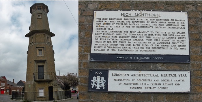
Harwich High Lighthouse is one of a pair of decommissioned lighthouses located in the seaside town of Harwich, on the Essex coast. The second of the pair is Harwich Low Lighthouse, with the two designed to be used in tandem to guide ships into the harbour at Harwich.
Three pairs of lighthouses have stood in the region over the years. The first pair were simple wooden structures, set up by Sir Willian Batten in 1664, who at the time was Surveyor of the British Navy. One lighthouse stood on top of the old town gate, while the other was positioned almost 200 metres away on the shore. The wooden lighthouses were pulled down and replaced in 1818 by two more substantial, brick lighthouses. Both of these still stand today, with Harwich High Lighthouse being one of them.
This pair were constructed under the order of John Rennie Senior. Rennie designed the Low Lighthouse himself, while the High Lighthouse was designed by an architect named Daniel Asher Alexander. The lighthouses belonged to General Francis Rebow, who made them into a very profitable enterprise by charging a fee on all cargoes coming into the harbour.
He sold the lease for the lighthouses to Trinity House in 1836, however it quickly became apparent that all was not well. Shingle deposits off the nearby coast had begun to obstruct the line of approach to the harbour that was indicated by the lighthouses, so much so that sailors began to refer to them as ‘the misleading lights of Harwich’.
As a result, the lights were declared redundant and two new, cast-iron lighthouses were built at nearby Dovercourt. Both brick lighthouses were kept however, and The Harwich High Lighthouse now houses a museum, under the custodianship of Harwich Society.
The High Lighthouse itself stands 32.8 metres (90 feet) tall and is a nine-sided tower made of gault grey brick. It is a Grade II* Listed Building, noted for being a fine example of a 19th century lighthouse. It is open daily to the public, for a small fee, and stands just opposite Harwich Train and Bus Station. Various exhibitions take place in the museum during the year, and visitors can climb the 100 steps to the top of the tower, which offers panoramic views out across the town harbour. Its twin, Harwich Lower Lighthouse, can also be visited.
Southwold Lighthouse, Suffolk
Southwold Lighthouse is an active lighthouse situated in the seaside town of Southwold, on the Suffolk coastline. It was designed as a coastal waymark for passing ships and as a guide to those wishing to enter into Southwold Harbour.
Southwold Lighthouse, as it is seen today, is the only proper lighthouse to have stood in the town. Construction began in 1887, with Trinity House embarking on the project after the front lights down the coast at Orford Ness were destroyed by severe storms. Construction was supervised by Engineer in Chief at Trinity House, Sir James Douglas, with the lighthouse coming into operation in September of 1890.
At first, the lighthouse was lit by an Argand oil lamp, which was eclipsed twice every 20 seconds and had a range of 17 nautical miles. However, just six days after the light was commissioned, disaster struck. The oil burner burst into flames and was destroyed – an event which was put down to the inexperience of the lighthouse keepers. The light was later replaced by an oil-fired light in 1906 and then a petroleum burner in 1923.
Southwold Lighthouse became electrified in 1938, but the most recent update to its light came as late as 2012. A new main light was installed with the aim of increasing the range of the lighthouse from 17 nautical miles to 24, mainly to compensate for the imminent closure of Orfordness Lighthouse just down the coast.
Southwold Lighthouse might have suffered the same fate as the one at Orfordness (which has since been demolished), as Trinity House briefly considered closing it in 2005. This was due to concerns that modern satellite navigation systems in ships had become more useful than the light. However, a review found that this was not yet the case, and so the lighthouse lived on.
The lighthouse remains operational to this day and is a prominent landmark within the town of Southwold. It stands 31 metres (102 feet) tall and is a cylindrical tower made of brick, which has been finished in all white paint. Its history and design have led to it being granted Grade II Listed status and it is a popular visitor attraction.
Tours of the lighthouse are arranged by Southwold Millennium Foundation, allowing visitors to climb the 113 steps of the lighthouse’s spiral staircase, where they can enjoy seeing the inner workings of a functioning lighthouse and get spectacular views from the top.
Lowestoft Lighthouse, Suffolk
Lowestoft Lighthouse is an active lighthouse located just to the north of the town of Lowestoft, in Suffolk. It overlooks the north sea coast and is situated near Ness Point – the most easterly part of the British mainland. This makes it the most easterly lighthouse in the UK.
During the late 16th and early 17th centuries, the eastern coastline of England was renowned for being a treacherous shipping lane, with the various sandbanks and shoals ending the lives of many ships, as well as crew. In 1609, this led to Trinity House building their first ever lights – two lighthouses on the foreshore near Lowestoft. Both were lit using candles, which when lined up guided sailors through the Stamford Channel, a dangerous passage which has since disappeared.
The original lighthouses were re-built twice, before one was eventually moved up the cliff in 1676 to the site where the current lighthouse now stands. This allowed the light – which was lit using a coal fire brazier – to be seen by ships further out. This ‘high light’ was a substantial lighthouse made of brick and stone.
In 1778, the visibility of the high light was improved as Trinity House began to experiment with reflector lights. The coal fire was therefore replaced by a glass lantern that stood 7 feet high and was lit using oil lamps.
The current lighthouse at Lowestoft was built in 1874, a decision made due to the previous tower being deemed unsuitable to take the weight of a modern electrified light. However, before the lighthouse could receive its modernised equipment, paraffin oil became available as a fuel for lights and was immediately deemed to be more efficient and practical than electrical lighting at the time. Three lighthouse keepers were in residence at Lowestoft Lighthouse around this time, making it a popular posting for those at Trinity House.
It wasn’t until 1938 when the lighthouse finally received electrification, with electric filament lamps being installed and connected to the mains. This paved the way for automation and today only one lighthouse keeper is required. The current light is one of the most powerful navigation lights in the UK, with a range of 23 nautical miles.
The modern lighthouse has a brick tower which is cylindrical in shape and finished in white paint. It stands at 16 metres high (52 feet). The two cottages originally used by the lighthouse keepers remain attached to the tower and the building is an iconic feature of Lowestoft, designated as a Grade II Listed Building. It is open to visitors and tours are conducted by the Lighthouse Attendant.
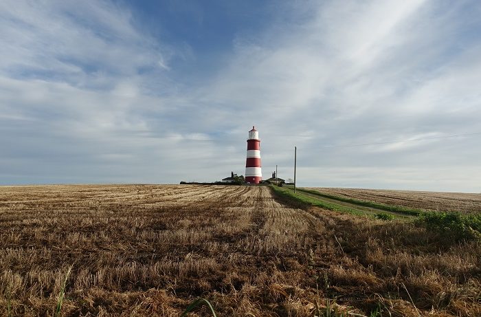
Happisburgh Lighthouse, Norfolk
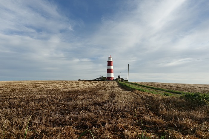
Happisburgh Lighthouse is an active lighthouse situated near the village of Happisburgh, on the North Norfolk coast. Built in 1790, it was designed to guide ships around the dangerous Haisborough Sands and is notable as being the only independently operated lighthouse in Great Britain.
The lighthouse at Happisburgh was built following a terrible storm in the east of England, which caused numerous ships to crash off the Norfolk coast and resulted in the loss of hundreds of lives. Soon afterwards, Trinity House decided to establish a pair of lights at Happisburgh to fill a gap between lights at Cromer and Winterton. The pair of lighthouses consisted of a Low Light located on the cliffs and a High Light (the current station) about 400 yards inland.
Originally, the lights of both towers were produced by rows of oil lamps in front of polished reflectors. A revolutionary new lantern was installed in 1868, formed of a diagonally-framed glass structure. This remains to this day and was a significant development at the time, allowing for the installation of a first-order catadioptric lens. A similar upgrade was made at the Low Light.
By the late 19th century, coastal erosion was an increasing threat to the Low Light, and it was eventually decommissioned and demolished in 1883. With the High Light remaining as the sole beacon, it was painted with horizontal red bands to distinguish it from the light at Winterton, while also having its character changed from fixed to occulting.
Paraffin vapour burners replaced the oil lights in 1904, before making way for an acetylene light in 1929. This allowed for a degree of automation and the lighthouse keepers left, with only an attendant remaining to check the light periodically. The keepers’ cottages were subsequently sold.
Happisburgh Lighthouse was electrified in 1947 and its character was changed again, this time to a group flashing characteristic of 3 flashes every 30 seconds. However, its days were seemingly numbered, as Trinity House announced in 1987 that Happisburgh was one of a number of navigation aids set to be discontinued.
Locals opposed this, however the Merchant Shipping Act of 1894 prevented Trinity House from passing the lighthouse on to anyone other than an established lighthouse authority. The Friends of Happisburgh Lighthouse came together to get a private bill through Parliament, enabling the Happisburgh Lighthouse Trust to take over the station in 1990.
Happisburgh Lighthouse has a cylindrical, masonry tower which is 26 metres (85 feet) tall. It is a Grade II listed building and the light has a range of 16 nautical miles.
Cromer Lighthouse, Norfolk
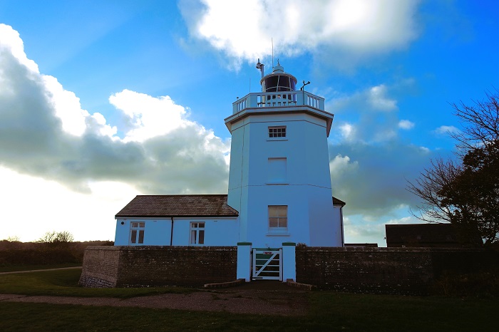
Cromer Lighthouse is an active lighthouse located in the seaside town of Cromer, in Norfolk, on a stretch of coastline known as the Cromer Ridge. The lighthouse at it stands today was built in 1833, however there has been a lighthouse in the area from as early as 1669.
Before this time, passing ships had to rely on makeshift lights for guidance, which were often shone from the top of the parish church in Cromer. Though small, these lights proved to be useful to sailors, though in the late 17th century it was noted that a more substantial light would be beneficial. It was Sir John Clayton who first made the proposal for a lighthouse at Cromer, along with five others around the British coastline.
He obtained a sixty-year patent from King Charles II, with dues for the lighthouse’s services to be paid voluntarily by shipowners. However, the cost of maintenance proved to be high and many shipowners were unwilling to pay, meaning Clayton was left unable to afford the fuel to light the tower. It therefore sat unlit for many years, instead being used as a daymark until it collapsed around the year 1700.
With the owner of the land, Nathaniel Life, keen for a working lighthouse to be in operation, he built a second lighthouse in 1717 – an octagonal tower which was three storeys high and illuminated by way of a coal fire enclosed in a lantern. Several upgrades followed, with Cromer Lighthouse becoming only the second lighthouse in England to display a flashing, revolving light in 1792. It is said that this new style of light was very irritating to seamen of the time.
The lighthouse was ill-fated however, with coastal erosion resulting in a series of landslips which ultimately destroyed it in 1866. This event had been expected for a number of years and plans were already in place for a new lighthouse – the current building. Beginning operation in 1833, this lighthouse was built half a mile from the cliff edge to ensure it did not suffer the same fate as its predecessor (it now stands far closer, however).
It is constructed in an octagonal shape and is a rather stocky building, reaching 18 metres (59 feet) high. The lighthouse is owned and operated by Trinity House and its light has a range of 21 nautical miles. With the light becoming fully automated in 1990, there was no need for lighthouse keepers and their huts are now rented out as holiday accommodation. While the lighthouse is not open to the public, it can be viewed easily on the surrounding coastline.
Old Hunstanton Lighthouse, Norfolk
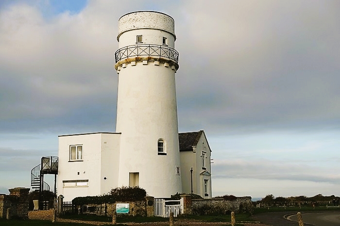
Old Hunstanton Lighthouse is a decommissioned lighthouse which stands on the cliffs near the village of Old Hunstanton, on the Norfolk coast. Built in 1840, the lighthouse helped to guide vessels into the sheltered waters of an area known as the Lynn Deeps, part of The Wash.
The famous striped cliffs of Hunstanton saw their first lighthouse constructed in 1665. Before this time, passing vessels had to rely on the lights of St. Edmund’s Chapel for guidance at night. With many lighthouses springing up around this period in time, a consortium of ship-owners sought permission to build one or more near St Edmund’s Point, to give sailors better waypoints when trying to enter The Wash at night.
King Charles II agreed to a warrant being issued, stipulating that a light or lights could be built on the Hunstanton cliffs as long as it was maintained through dues paid by passing ships – a practice which at the time was widespread among lighthouse owners. The warrant was issued to John Knight, who oversaw the construction of a pair of stone towers in 1665, one lit by candle and the other by coal-fired brazier.
The first pair of lighthouses were reportedly of great use to sailors and remained functional for many years, until the front lighthouse was taken out of commission around the mid 18th century. It is unclear what happened to this lighthouse, however a 1794 map by English cartographer John Cary showed it has disappeared. The second lighthouse was also ultimately doomed, being destroyed by a fire in 1776.
The lighthouse was quickly replaced with a new wooden once, which became one of the first major lighthouses in the UK to be fuelled by a substance other than coal, when it was equipped with oil lamps. It was also fitted with parabolic reflectors, which is though to have been a global first at the time. It was eventually purchased by Trinity House in 1836.
The current Old Hunstanton Lighthouse replaced this one just four years later, with engineer James Walker designing the building. It took the shape of a cylindrical brick tower, standing 19 metres (63 feet) high and finished in white paint. A pair of two-storey cottages were attached on either side, originally to house the lighthouse keepers.
Old Hunstanton Lighthouse remained in operation for all of 81 years, until it was deemed surplus to requirements in 1921. It was decommissioned and later had its lantern storey removed, before it was sold at auction in 1922 for £1,300. It was briefly used as an observation point by the Royal Observer Corps but it now functions as a holiday let, providing holiday-makers with panoramic sea views.
Spurn Point Lighthouse, Yorkshire
Spurn Point Lighthouse is a decommissioned lighthouse located on the southern tip of the tidal island of Spurn, at the tip of the East Riding of Yorkshire. The lighthouse was built in 1895 to replace a pair of previous lights used to guide ships past the island.
The first lighthouse at Spurn is thought to have been established in the 15th century, and from the 17th century there were a pair of leading lights on Spurn Point. However, by about 1766 the shifting sands at Spurn point had left the towers so far inland that they were rendered useless for navigation. Engineer John Smeaton was commissioned to design two new lighthouses in 1767, which were both completed and lit by 1776.
The upper lighthouse was made of brick and was built 27 metres high. Both towers were lit using coal fires initially, until these were replaced with oil lamps and reflectors in 1816. In 1853, a first-order Fresnel lens was installed at the high light, with a red sector added to warn ships of dangers to the south of the point. At a similar time, the low light was replaced due to the ongoing movement of Spurn Point, and a smaller Fresnel lens was installed in the new tower.
Problems with the lights continued however, especially when cracks were discovered in the brickwork of the high light in 1892, likely caused by movement in the foundations. In light of this, both towers were replaced with a new lighthouse – the current Spurn Point Lighthouse – in 1895. Only the foundations of the old high light remain on the point, whereas the old low light is still visible, topped nowadays by a water tower rather than a lantern.
The new lighthouse was designed by engineer Sir Thomas Matthews and was provided with a hyper-radiant optic housing oil lamps, which displayed a flash once every 20 seconds and had a range of 17 nautical miles. The light was converted to electrical operation in 1941, during World War II, so that it could be quickly lit and extinguished as required. It was then upgraded to acetylene gas in 1957, which allowed for automation of the light.
As navigation technology improved, the need for the Spurn Point Lighthouse slowly diminished, and it was eventually decommissioned in 1985, after 90 years of service. The tower remained disused for almost three decades, until Yorkshire Wildlife Trust was awarded a grant to restore the lighthouse and turn it into a visitor centre.
Spurn Point Lighthouse has a cylindrical brick tower which is painted black and white, and stands 39 metres (129 feet) high. It is now fully open to the public.
Withernsea Lighthouse, Yorkshire
Withernsea Lighthouse is a decommissioned lighthouse located in the town of Withernsea, in the East Riding of Yorkshire. Built in 1894, it was designed to be used as a beacon for passing ships.
Construction of the lighthouse was prompted by the relatively high incidence of shipwrecks along the Withernsea coast, thought to be due to sailors being unable to see the nearby lights at Flamborough or Spurn. Strangely, the lighthouse lies almost 400 metres (about a quarter of a mile) from the coastline, making it one of the few inland lighthouses on the British coast.
This unusual positioning was due to fears that coastal erosion would result in the destruction of a lighthouse that was built closer to the sea. In addition, there was nothing to obstruct the view of the lighthouse at the time, meaning it was still a prominent sight when viewed from the sea. Since then, the town of Withernsea has gradually grown around it and the lighthouse now stands near the town centre.
It was first lit with an eight-wick paraffin lamp housed within a fixed Fresnel lens. The light was originally eclipsed three times every minute, using a clockwork mechanism, however in 1936 it was electrified. The new electric light had a range of 17 miles.
In fact, Withernsea was one of the first lighthouses in northern England to receive electrification, and it was also one of the earliest Trinity House lighthouses to have an emergency lighting system installed, in case the main lamp were to fail. This backup system was later adopted by many of the Trinity House lighthouses.
Withernsea lighthouse was designed to be 39 metres tall (128 feet) with an octagonal shape, with two adjoining keepers’ cottages. Until its decommission in 1976, the lighthouse was operated by a married couple of lighthouse keepers. It ceased operations on 1 July of that year, with the light deemed to be no longer needed.
Today, Withernsea Lighthouse is a Grade II Listed Building and houses the Withernsea Lighthouse Museum. It is a popular tourist destination, featuring historical exhibits based around the RNLI and HM Coastguard’s operations in the region. Visitors can climb the 144 steps to the top of the lighthouse tower, for commanding views of the surrounding town and coastline. On clear days, it is even possible to see the Humber Bridge.
Flamborough Head Lighthouse, Yorkshire
Flamborough Head Lighthouse is an active lighthouse in the East Riding of Yorkshire, located on a headland near the village of Flamborough. It functions as a waypoint for passing ships, as well as marking Flamborough Headland for vessels bound for the nearby ports of Scarborough and Bridlington.
The first lighthouse to appear at Flamborough was an octagonal chalk structure which was completed in 1674. Built by Sir John Clayton, the lighthouse was unfortunately never lit, due to him going bankrupt shortly after its completion. However, the structure remains to this day, making it one of the oldest known lighthouses still in existence in the UK.
The old lighthouse stands slightly inland from the current lighthouse, which was designed by Samuel Wyatt and built in 1806. When it was first lit, Flamborough Head Lighthouse had a distinctive light characteristic of two white flashes and one red flash. This was due to one of the three sides of the parabolic reflectors having red glass – a characteristic which was designed to distinguish the lighthouse from the one at nearby Cromer. This was the first ever use of colour in a lighthouse light and the practice quickly became common around Britain.
In 1872, a new paraffin lamp was installed in the lighthouse. This was another first, as until this time none of Trinity House’s lighthouses had used paraffin as fuel. With a new first-order dioptric optic being installed at the same time, the new light had a nautical range of 21 miles.
The lighthouse was electrified in 1940, with its fog signal station receiving the same modification a few years later. This replaced the previous fog warning system, which had involved the firing of a rocket once every five minutes. The upgrades paved the way for automation and the last lighthouse keepers at Flamborough left in May of 1996.
The lighthouse remains in the hands of Trinity House and is a Grade II Listed Building. Cylindrical in shape, the tower is made of brick and painted solid white, with a height of 26.5 metres (87 feet). It has a first order catadioptric rotating lens, which has a range of 24 nautical miles. It is open to visitors during the spring and summer, and the surrounding headland is a spectacular place for walking.
Scarborough Pier Lighthouse, Yorkshire
Scarborough Pier lighthouse is an active lighthouse situated on Vincent Pier in the town of Scarborough, in North Yorkshire. The lighthouse was first built in 1806, designed to be used as an aid to navigation for ships wishing to enter the town harbour.
Although the lighthouse first appeared on Vincent Pier in 1806, lights had been shone to guide ships into the harbour since 1804. The lighthouse simplified the task however, and in its earliest form was constructed as a circular brick tower topped with a coal-fired brazier. Operating as a tide-light, the brazier would be lit as the tide was half-way in and extinguished as it was half-way out.
It was soon replaced by six tallow candles, with a lighthouse keeper posted to replace the candles as they extinguished. In the 1840s, it was decided that the lighthouse keeper and the harbour master should be provided accommodation, and several buildings were added to the lighthouse tower. At this time, substantial improvements were also made to the tower itself, with its height being increased by 5.2 metres (17 feet). This increased the light’s visibility from sea.
Scarborough Pier Lighthouse then endured a quiet few decades, but that all changed in 1914, when the lighthouse experienced a dramatic period of time known as “the bombardment”. On 16 December of that year, shortly after the beginning of World War I, two German battle cruisers caught the town of Scarborough completely off guard. They hammered the town with over 500 shells in an early-morning raid, killing 18 residents and causing extensive damage.
The lighthouse became an additional casualty. While it survived the initial bombardment, the final shell to hit the town struck the centre of the lighthouse tower and, although it did not explode, the structural damage proved to be terminal. To prevent its collapse, the top half of the tower was demolished.
Thankfully, enough public funds were raised that the lighthouse was restored in 1931. Retaining its cylindrical shape, it was built to a height of 15 metres (49 feet) and topped with an octagonal lantern. A foghorn was also added. The current light has a range of 9 nautical miles.
While Scarborough Pier Lighthouse may not be the tallest or most impressive lighthouse to look at, it certainly has one of the most dramatic stories and it remains an important part of the town to this day. It is owned by Scarborough Borough Council and the tower’s lodgings are used by the Scarborough Yacht Club, after having been vacated by the harbour master in 1937.
Roker Pier Lighthouse, County Durham
Roker Pier Lighthouse is an active lighthouse built on the end of Roker Pier, in the city of Sunderland. The lighthouse was established in 1903 to help guide ships into the Sunderland docks.
From the early 18th century, improvements began to be made to Sunderland’s harbour entrance at the mouth of the Weir, courtesy of the recently-formed River Wear Commission. A pair of breakwaters were constructed by 1796, known as the North and South Piers. Sunderland’s first lighthouse was built on the North Pier in 1803, taking the form of an octagonal stone tower. This was later moved when the pier was extended.
A new lighthouse was built in 1856, this time on the South Pier. Designed by Thomas Meik, this tower was cylindrical and made of cast-iron. As the port of Sunderland continued to grow, the two piers were deemed no longer adequate to protect the harbour. As a result, a new outer harbour with two curved piers was built, designed by Henry Hay Wake, chief engineer at the River Wear Commission. This was completed over several years and was hailed as a great feat of engineering.
In 1903, construction of the current Roker Pier Lighthouse was also completed, with the tower situated on the new North Pier. A third-order rotating catadioptric optic was installed at the top of the tower. It was originally lit by gas from the town mains and flashed once every five seconds, however the supply of gas to the end of the pier was often intermittent, leading to an incandescent vapour lamp replacing the gas one. This also increased the strength of the light.
A compressed air fog signal was installed at the tower, driven by a clockwork mechanism and sounding a blast every 20 seconds in poor visibility. A new fog horn was fitted in 1972, while the lighthouse was automated at the same time, following the installation of six sealed beam lamps. The old optic was moved to Sunderland Museum & Winter Gardens.
A new LED lamp array was fitted in 2012, and a series of refurbishments culminated in the lighthouse being opened to the public for the first time in 2018.
Roker Pier Lighthouse has a tapered cylindrical tower, which is made of red and white granite. It is a Grade II listed building and it reaches a height of 23 metres (75 feet). The light has a range of 23 nautical miles.
Souter Lighthouse, County Durham
Souter Lighthouse is a decommissioned lighthouse in the village of Marsden in County Durham. It was built in 1871 to warn passing ships of the treacherous rocks of Whitburn Steel reef.
At the time of its construction, this was desperately needed, as the reef had become notorious for shipwrecks. In fact, as many as 20 ships foundered on the rocks in the space of a year in 1960, making this part of the coastline – just a few miles south of the mouth of the River Tyne – one of the most dangerous stretches of coastline in the country.
Designed by civil engineer Sir James Douglass, the lighthouse was constructed on Lizard Point, just outside Marsden. However, due to fears it would be confused with the already established Lizard Lighthouse in Cornwall, the lighthouse was instead named after Souter Point, which lies about a mile to the south.
It was the first lighthouse in the world to be purpose built to run on electricity. And when it began operations in 1871, it was a technological marvel, noted for being one of the most powerful lights in the world. The main lens consisted of a third-order catadioptric optic, surrounded by a revolving assembly which produced a flash once per minute. The optics were designed by James Chance and built upon several years of experimentation by Trinity House. Electricity was provided by two electric generators, which remained up until 1914, when the pioneering light was replaced with oil lamps and a much larger catadioptric optic was installed. This lens remains in place to this day and has a range of 26 nautical miles.
In 1952, it was again converted to run on electric power but the lighthouse was decommissioned just 40 years later, after 117 years of service. The development of modern navigational aids such as GPS meant the light was no longer needed. After a short spell functioning as a radio navigation beacon, it was eventually closed in 1999.
Today, Souter Lighthouse is owned and managed by the National Trust. It is a Grade II* listed building, formed of a brick tower which stands 23 metres (77 feet) high. It is finished in white paint with one red horizontal band. The building’s foghorn and lighthouse keepers’ cottages remain in place, though the cottages are now used as holiday accommodation.
The foghorn is often sounded to visitors, who can book tours of the tower and living quarters and enjoy impressive views of the surrounding coast. Interestingly, the lighthouse is said to be haunted by one of the former keepers.
St. Mary’s Lighthouse, Northumberland
St. Mary’s Lighthouse is a decommissioned lighthouse located on the small island of St. Mary’s, a short distance north of Whitley Bay in Northumberland. Constructed in 1898, it was tasked with protecting passing ships from the dangers of the rocks and islets on the surrounding coastline.
Although St. Mary’s Island is now a tidal one, it was once connected to the mainland, before coastal erosion eventually led to it being cut off at high tide. It is thought that the island was once used by monks from Tynemouth Priory in the 7th century, before a chapel was constructed in the 11th century, dedicated to St. Helen. At this time, a light burned within the chapel as a warning to sailors.
There was no lighthouse on St. Mary’s Island for many years, with the closest being the lighthouse at nearby Tynemouth. However, there were several large shipwrecks on or near the island during the latter half of the 19th century and this prompted construction of the current St. Mary’s Lighthouse. Designed by Sir Thomas Matthews, engineer-in-chief to the Trinity House Board, the lighthouse was finished in 1898. A pair of lighthouse keepers’ cottages were completed the following year.
The lighthouse was originally lit with a kerosene lamp, which flashed twice every 20 seconds. It wasn’t until 1977 when the lighthouse was eventually electrified, meaning St. Mary’s Lighthouse was the very last Trinity House lighthouse to be lit using oil. The original first-order Fresnel lens was removed upon the lighthouse’s electrification, and moved to the National Lighthouse Museum in Cornwall. It was replaced by a revolving sealed beam light array.
However, it wasn’t long before Trinity House made the decision to decommission the lighthouse, due to the advancement of modern navigational aids. St. Mary’s Lighthouse ceased operations in 1984. When it was lit, it had a range of 17 nautical miles.
The lighthouse is formed of a brick cylindrical tower, which stands 46 metres (151 feet) high and is finished in white paint. It is a Grade II listed building and is now operated by North Tyneside Borough Council as a visitor attraction. As well as the lighthouse itself, there is a small museum and a visitor centre, housed in the original keepers’ cottages. The island can be reached at low tide via a causeway and visitors can climb the 137 steps to the top of the lighthouse tower, as well as enjoy the wildlife of the surrounding St. Mary’s Nature Reserve.
Coquet Lighthouse, Northumberland
Coquet Lighthouse is an active lighthouse located on the south-west of the island of Coquet, on the Northumberland coast. Built in 1841, it was designed to warn passing ships of the island’s presence.
Built by Trinity House, the lighthouse was designed by James Walker and is an unusual structure, in part due to it being built upon the remains of a medieval monastery, which lay abandoned on the island for many years. It was completed at a cost of £3,268 and was initially provided with a first-order fixed dioptric, together with a series of mirrors. At this time, it was lit with an oil lamp.
The first lighthouse keeper to oversee the station at Coquet was William Darling, the brother of Grace Darling – who was made famous by her heroics at the nearby Longstone Lighthouse. After about 10 years, the mirrors in the light were replaced by refracting prisms, while red sectors were added in 1854 to warn ships of Hauxley Point to the South and Boulmer Rocks to the north. An additional sector light was later added, facing southwards. The original optic is now on public display at Souter Lighthouse.
In 1891, the main light was made more powerful by the installation of an eight-wick oil burner, replacing the old lamp. Its character was changed at the same time, from fixed to occulting. As the island remained a danger to ships in foggy weather, an explosive fog signal was fitted at the beginning of the 20th century, sounding once every seven and a half minutes. The gap between these signals was later reduced.
The oil light was replaced with a paraffin vapour burner, before the station was eventually electrified in 1976. It was then automated in 1990 and an array of sealed beam lamps were installed, mounted on a rotating pedestal to produce three flashes every 30 seconds. The light is now solar powered.
Coquet Lighthouse has a square, sandstone tower which is painted white at the top half. It is a Grade II listed building and the tower is 22 metres (72 feet) high. The surrounding island is managed by the RSPB as a bird reserve, and is an important breeding ground for puffins and roseate terns.
Longstone Lighthouse, Northumberland
Longstone lighthouse is an active lighthouse located on Longstone Rock – one of the outer Farne Islands, off the Northumberland coast. It was built in 1826 as a navigational aid for ships passing the Farne Islands and is best-known for the infamous sinking of the Forfarshire.
The rocks around the Farne Islands were known for being treacherous to passing ships for many years and numerous attempts to establish a lighthouse on the islands were undertaken during the late 17th and early 18th centuries. Unfortunately, on each occasion Trinity House was unable to persuade merchants to pay dues to maintain the proposed lights, and so they never came to fruition.
That was until 1776, when Trinity House gave Captain John Blackett permission to build two lighthouses on the islands, at his own expense. He constructed a pair of coal-fired beacons, which were first lit in 1778 and were replaced on several occasions over the next few decades due to repeated storm damage. Shipwrecks continued to occur however, and 100 lives were lost in the region from 1823 – 1824.
This prompted Trinity House to take action, purchasing the land from the Blackett family and building the current lighthouse on Longstone Rock, one of the furthest outlying islands. Located almost 5 miles off the coast, conditions for the lighthouse keeper and his family were often harsh, with storms bringing waves that would dwarf the living quarters.
William Darling was lighthouse keeper at the time, though his daughter Grace Darling is better known nowadays. In September 1838, Grace spotted the paddlesteamer Forfarshire stricken on nearby rocks one morning. The ship had broken in half overnight, with the loss of 43 lives.
Survivors remained clinging to the debris, but the conditions were bad enough that William thought it too dangerous to attempt a rescue. Grace persuaded him and together they set out in a rowing boat, struggling through a mile of treacherous seas. Two trips were made, and their actions saved the lives of 9 people. Both Grace and William were later awarded the silver medal for bravery by the RNLI, and Grace became quite famous.
The drama for Longstone Lighthouse did not end there, as its fog signal station was later destroyed by bombing in World War II. It was electrified in 1952, automated in 1990 and remains active to this day. It has a 26 metre (85 foot) high stone tower, which is painted with red and white bands and is a Grade II listed building. Its light has a range of 18 nautical miles.
St. Abb’s Head Lighthouse, Berwickshire
St. Abb’s Head Lighthouse is an active lighthouse located on St. Abb’s Headland, on the Berwickshire coastline. It marks the southern entrance to the Firth of Forth and was built in 1862 to help provide safe passage for ships.
A signal station was present on St. Abb’s Head before 1820, however the main catalyst in the decision to built a lighthouse was the 1857 sinking of the Martello – a Scottish paddlesteamer. The ship became wrecked on the Carr Rock during fog, with about 40 people onboard. Luckily, all were saved, but plans to design the lighthouse began soon afterwards.
St. Abb’s Head Lighthouse was designed and built by David Stevenson and Thomas Stevenson, two brothers who worked as engineers for the Northern Lighthouse Board (the general lighthouse authority for Scotland). The Stevensons were a talented family, and indeed David was the father of Treasure Island author, Robert Louis Stevenson.
Completed in 1862, the lighthouse was first lit with an oil-burning light. In 1876, a fog signal station was established alongside the lighthouse. Driven by hot air engines, this was the very first siren fog signal in Scotland. As well as its primary function, St. Abb’s Head Lighthouse was also used as the communication control station for the Firth of Forth lighthouses.
It was staffed by three full-time lighthouse keepers for a number of years, who looked after the light while also keeping detailed weather records. Unusually, the keeper’s house is not directly connected to the lighthouse itself, instead sitting 90 metres up the cliff. The buildings are linked with a steep staircase.
The lighthouse and fog signal station received upgrades near the beginning of the 20th century. The oil-fulled light was upgraded to an incandescent one in 1906, while the fog signal station’s air-driven engines were replaced with oil-driven ones in 1911. The fog signal was eventually discontinued in 1987, although the horn remains in place. St. Abb’s Head Lighthouse was automated in 1993 and remains active to this day.
With a masonry tower measuring 9 metres (30 feet) high, it may be one of the shortest lighthouses in the UK but it is certainly a unique structure. It is one of only a handful of lighthouses reached by way of a flight of stairs and its precarious position on the 300 foot high cliffs of St. Abb’s Head makes it an impressive sight, though it is not open to the public. It has a Fresnel lens which produces a flash once every ten seconds, and the light has a range of 18 nautical miles.
Bass Rock Lighthouse, East Lothian
The Bass Rock Lighthouse is an active lighthouse perched on the tiny Bass Rock, in the outer portion of the Firth of Forth. It is a relatively new lighthouse and was built in 1902, to be used to aid the navigation of ships passing the coast.
The Bass Rock is a large crag that rises out of the ocean to a height of 350 feet. It lies about a mile offshore and during the late 19th century the lack of any lights in the region was of great concern to the Northern Lighthouse Board. A decision was made to built a lighthouse on the Bass Rock, in tandem with a second lighthouse on the nearby mainland, near Dunbar (Barns Ness Lighthouse).
Construction on the Bass Rock proved to be a challenge, with the chosen site being a rather awkward one to build on. The engineer was David Stevenson, who oversaw the lighthouse’s successful construction in 1902, at a cost of £8,087. The Bass Rock had previously been home to a 16th century chapel, which became a fortress and prison for many years. Between 1672 and 1688, 40 prisoners are said to have died in the prison’s dungeons.
Rocks from the fortress were used in construction of the lighthouse and it now sits on the fortress’ remains. It was originally lit by way of incandescent gas obtained from vaporised paraffin oil. Three lighthouse keepers were posted to the lighthouse, with each spending a month on the rock, followed by two weeks off. It was a wild and remote place to be, especially during winter. The light was later upgraded to a biform ML300 synchronised electric lamp, and was automated in 1988.
The Bass Rock Lighthouse has a cylindrical, stone tower which is 20 metres (66 feet) high. It is painted white, with the lamp having a black dome. The light has a range of 10 nautical miles and flashes three times every twenty seconds.
As the lighthouse keepers have long since departed, the Bass Rock and indeed the lighthouse itself have effectively been claimed by the world’s largest gannet colony, as well as a number of other seabird species. During breeding season, the birds cover almost every available inch of the rock, with some even building their nests on the lighthouse too.
Inchkeith Lighthouse, Fife
Inchkeith Lighthouse is an active lighthouse located on the island of Inchkeith, in the Firth of Forth. The island lies just a few miles from Edinburgh and has been of strategic importance for centuries. The lighthouse was built in 1803 to warn ships of the surrounding rocks.
The island of Inchkeith has a varied and interesting history, having previously been the site of a Medieval castle, a quarantine for disease-stricken individuals and the site of some hefty World War II guns. It was always a danger to ships however, and the wreck of the Aberdeen in 1801 convinced the Northern Lighthouse Board to build a lighthouse.
Inchkeith Lighthouse was designed and built by Thomas Smith and Robert Stevenson. Completed in 1803, it was first lit in 1804. It was fitted with Argand lamps and silvered copper reflectors, which at the time were state-of-the-art.
The lighthouse’s close proximity to the Northern Lighthouse Board’s headquarters in Edinburgh meant it was often one of the first in Scotland to receive new lighting innovations. A new form of reflector oil lamp developed by Smith was first tried here, and Inchkeith was converted into one of the earliest flashing lights in 1816. It was then fitted with the UK’s first dioptric light in 1835, based on the Fresnel system. Upgraded not long after, the light had a range in good visibility of 21 nautical miles.
In 1899, a foghorn was installed at the lighthouse, operating on compressed air. Despite being useful, it is reported that a problem with the foghorn on one occasion resulted in it sounding continuously for over five days, something which caused much discontent to those in earshot. Later, Inchkeith lighthouse was chosen as a station for a series of experiments for a programme of wireless fog signals. The foghorn was eventually decommissioned in 1904.
The lighthouse continued to be operational and indeed it still is today. Though once being looked after by several lighthouse keepers, it was automated in 1986. The current light is formed of an array of sealed beam lamps and has a range of 22 nautical miles. It flashes once every 15 seconds.
The lighthouse tower is cylindrical in shape and stands 14 metres (45 feet) tall. The building is an unusual structure, painted yellow-ochre in colour and designed with an almost castle-like appearance. It is a Grade B listed building and is now owned by Forth Ports, having been passed over by the Northern Lighthouse Board in 2013.
Isle of May Lighthouse, Fife
The Isle of May Lighthouse is an active lighthouse found on the Isle of May, at the mouth of the Firth of Forth. Located about five miles from the Scottish mainland, the lighthouse was built in 1816 to assist in the navigation of passing ships.
The current lighthouse was not the first to be built on the island. A patent was granted to three men by King Charles I, and construction of the first Isle of May lighthouse was completed in either 1635 or 1636. The lighthouse was a rather rudimentary one, consisting of a stone structure topped by a coal fire. Coals were hoisted into the fire by way of a box and pulley, which required three people to operate it all year-round.
At the time, it was one of the finest lighthouses in existence. However, it was not without problems. Almost an entire lighthouse keepers’ family were suffocated by fumes in 1790, when accumulated ash near a window was set smouldering. The light was also very inconsistent depending on the weather conditions, and two ships were wrecked near Dunbar in December 1810 after mistaking a lime kiln on the coast for the lighthouse.
The Northern Lighthouse Board purchased the island four years later, building a much more modern structure in 1816 – the current lighthouse. The old lighthouse remains to this day, though it is much reduced in height, and it is often considered the oldest surviving lighthouse in the UK.
The new lighthouse was designed by Robert Stevenson and was upgraded in 1836 to be fitted with the first British dioptric fixed light. A second lighthouse (a low light) was constructed a few hundred yards away in 1843 to help ships avoid the North Carr rock. This was later made redundant by the North Carr Lightship, though the building still remains.
The main lighthouse saw extensive improvements between 1885 and 1886, with the addition of several keepers’ cottages, a boiler house, an engine house and a coal store. 150 tonnes of coal were needed per year to keep the light going and the high cost of this, together with advancements in oil lights, led to it being replaced with an incandescent mantle in 1924. It was fully automated in 1989.
The Isle of May Lighthouse is a stone structure with a quadrangular tower that stands 24 m (79 feet) high. It is a Category B listed building and is noted for its gothic architecture, with castellated stone that makes it look a bit like a castle. The light flashes twice every fifteen seconds and has a range of 22 nautical miles.
Bell Rock Lighthouse, Angus
The Bell Rock Lighthouse is an active lighthouse located on the Bell Rock – a reef lying around 11 miles off the Angus coast. The lighthouse was built in 1810 to warn ships passing the coast or entering the Firth of Tay.
As the rock on which it is built is only uncovered for a few hours at low tide, the Bell Rock Lighthouse is the oldest surviving sea-washed lighthouse in the world. Due to the enormous challenges faced in its construction, it is also sometimes considered to be one of the wonders of the industrial world.
Prior to construction, the Bell Rock was a deadly threat to shipping in the region, claiming several ships every year. The catalyst for building the lighthouse was the wreck of the HMS York in 1804, which sank with the loss of all 493 lives onboard. The Northern Lighthouse Board awarded a contract to design and build the lighthouse soon afterwards to John Rennie, appointing Robert Stevenson as chief assistant in the process.
Construction began in 1807 and took three years in total. At first, the workers resided in a ship moored off the rock, however a temporary wooden house on struts was soon built to house them on the rock itself. Due to the extreme location of the site, the work was slow, difficult and dangerous. Numerous injuries were suffered by the workers and three lives were lost, including one young worker who was knocked unconscious and drowned.
It was eventually completed at a cost of £42,000 (a substantial figure at the time), with around 2,500 granite stones being used in the process, all of which were carried by one horse, known as Bassey. Although Stevenson took most of the credit for the construction, Rennie was later recognised as having a significant role too.
The light at the Bell Rock was not exhibited unless by request during the two World Wars, and this led to the unfortunate sinking of the HMS Argyll in 1915, though all onboard were saved. The light was also damaged during a helicopter accident in 1955, when an RAF helicopter which was performing a sea-winching exercise struck the tower and crashed into the sea.
The light was repaired and it remains active to this day, though it has seen several improvements over the years. The lighthouse was automated in 1998, which quite possibly came as a relief to the lighthouse keepers. The lighthouse’s incredibly isolated location led to a very high incidence of resignation among its keepers and it must have been a harrowing place to be during winter storms.
The lighthouse is a granite tower, standing 36 metres (118 feet) high, topped with a hyperradiant Fresnel lens with a range of 18 nautical miles.
Scurdie Ness Lighthouse, Angus
Scurdie Ness Lighthouse is an active lighthouse situated on a headland alongside the River South Esk estuary, just outside the town of Montrose in Angus. Built in 1870, it was designed to aid the navigation of ships passing the coast or entering Montrose harbour.
The lighthouse gets its name from the Scurdie Ness headland on which it is built. Scurdie is a local word for the volcanic rock in the area, while Ness means headland. For many years, the entrance to the River South Esk estuary was a dangerous place for ships. As many as 11 wrecks have been recorded at the mouth of the estuary and there was substantial loss of life through the 19th century.
In 1867, the seafaring community of Ferryden (a village just outside Montrose) requested that a lighthouse be built on the Scurdie Ness headland to help provide safe passage for ships. The Northern Lighthouse Board agreed and, three years later, the lighthouse was completed. It was designed and built by David and Thomas Stevenson.
Originally, the light characteristic was fixed white, however it was altered to an isophase pattern of 30 seconds of light, followed by 30 seconds of eclipse. During World War II, the light was extinguished and was only illuminated when requested by the Royal Navy. In addition, one lightkeeper at the time underwent the enormous task of painting the entire tower black, so that it would not provide a day mark for German aircraft.
The lighthouse was repainted white after the war had ended and was looked after by lighthouse keepers up until 1987, when it was automated. Nowadays, the light flashes three times every 20 seconds and has an intensity of 182,000 candela, meaning on a clear night it can be seen 23 nautical miles away.
Scurdie Ness Lighthouse remains under the ownership of the Northern Lighthouse Board, although some of the buildings at the site are now privately owned. Its stone tower stands 39 metres (128 feet) high and the building is Category B Listed. As the area is home to many types of seabird, there is a statue of an owl perched on the lighthouse balcony, beneath the lantern, to try and keep them away from the light.
The headland is a popular walking spot and although the lighthouse isn’t open to the public, great views of it can be enjoyed from the surrounding area.
Girdle Ness Lighthouse, Aberdeenshire
The Girdle Ness Lighthouse is an active lighthouse found on the Girdle Ness peninsula, just to the south of Aberdeen’s harbour entrance. Constructed in 1833, it was designed to aid the navigation of ships passing the coast or entering Aberdeen Harbour.
The lighthouse was built at Girdle Ness twenty years after the wreck of a whaling ship called the Oscar in 1813. The wreck was not due to a lack of light, as the ship was blown onto rocks during a storm while anchored, however 42 of the 44 men onboard were lost, prompting calls for a lighthouse to be built.
Girdle Ness Lighthouse was designed by Robert Stevenson and built by James Gibb, a local contractor. Initially, the lighthouse exhibited two distinct lights, one on top of the other. The lower light consisted of 13 lamps and reflectors, positioned at the height of the watch room about a third of the way up the tower. It was visited in 1860 by Astronomer Royal Professor George Airy, who described it as “the best lighthouse that I have seen”.
Paraffin was used experimentally to fuel the light for a short time in the late 19th century, but in 1890 the main light was replaced by a revolving light and the secondary light was discontinued. Shortly afterwards, a foghorn was established next to the lighthouse. The foghorn was operated when visibility dropped below 5 nautical miles. It had a very distinctive sound and was nicknamed the Torry Coo, in reference to it sounding like a cow (coo being the Scottish slang term for cow).
In November 1944, during World War II, Girdle Ness Lighthouse sustained minor damage when a mine drifted into the bay below and exploded. A few windows were smashed and doors were damaged, but no one was injured. The fog signal was eventually discontinued in 1987, while the lighthouse was automated four years later.
The lighthouse tower is cylindrical in shape and painted white, topped with a black lantern. It stands 37 metres (121 feet) high and is a Category A listed building, with lighthouse keepers’ accommodation and other buildings attached. Some of the attached buildings have been sold by the Northern Lighthouse Board and the original keepers’ accommodation is now used as holiday accommodation. The light at Girdle Ness has a range of 22 nautical miles and flashes twice every 20 seconds.
Buchan Ness Lighthouse, Aberdeenshire
Buchan Ness Lighthouse is an active lighthouse situated on the Buchan Ness promontory, just outside the village of Boddam in Aberdeenshire. It was built in 1824 to aid the navigation of ships passing the coast or entering Boddam Harbour.
The lighthouse is just a few miles south of Peterhead, which has long been a key fishing port in the UK. In the late 18th and early 19th centuries, the coast around the Buchan Ness promontory saw a high volume of traffic related to trading and whaling operations. A number of vessels ran aground over the years, and the Northern Lighthouse Board was petitioned to build a lighthouse in the area in 1819.
As Engineer to the Board at the time, Robert Stevenson surveyed the area and decided on Buchan Ness as the best site for the lighthouse. The promontory is a tidal island, and at the time it was only connected to the mainland at low tide. Thus, a bridge was built to help in the lighthouse’s construction. Despite being completed in 1824, it wasn’t until 1827 that the light was first exhibited.
The original ‘twinkling’ light was produced from an array of Argand burners with silvered copper reflectors, which revolved more quickly than any previous light developed by Stevenson. At the time, it was noted for its ingenuity, though it has been upgraded several times since then. It was changed to a dioptric lens in 1910, before being much enlarged in 1978.
Buchan Ness Lighthouse, much like Girdle Ness Lighthouse down the coast, suffered minor damage during World War II when a mine drifted ashore and exploded 50 yards south of the station. Parts of the ceiling collapsed in one of the lighthouse keeper’s cottages and a few of the lighthouse’s lantern panes were cracked, but no one was injured.
At the same time as the light being enlarged in 1978, it was also electrified, ten years before it was eventually automated. There was an active fog signal station alongside the lighthouse for many years, but this was discontinued in 2000.
The lighthouse remains under ownership of the Northern Lighthouse Board, though some of the associated buildings have been sold off in recent years. The building itself is Category A listed and the tower is made of granite, standing 36 metres (118 feet) tall. It is painted white with a red band and red balcony, to ensure it can be used as a daymark. The light has a range of 18 nautical miles and flashes once every five seconds.
Kinnaird Head Lighthouse, Aberdeenshire
Kinnaird Head Lighthouse is an active lighthouse located on a headland just outside the town of Fraserburgh, on the north-east coast of Scotland. There are actually a pair of lighthouses here – a historic one dating from 1787 (now deactivated) and the current, active one which was built in 1991.
Situated at the turning point where the coastline of eastern Scotland curves westwards towards the Moray Firth, Kinnaird Head has always been an important landmark for shipping, even prior to it having a lighthouse. The original light was established in 1787 and was built by a Mr Thomas Smith – father-in-law of the renowned lighthouse engineer Robert Stevenson. It became the very first lighthouse to be constructed by the Northern Lighthouse Board.
Smith built the lighthouse upon the tower of an old castle, with the lantern sitting 120 feet above sea level. Fuelled by whale oil, it was the most powerful light of its time in Scotland, containing 17 reflectors arranged in a three-tied formation. In clear weather, it was reportedly visible for between 10 to 12 nautical miles. A new lantern was installed in 1824 and additional buildings for lighthouse keepers were constructed, before the light was later converted to incandescent operation.
A foghorn was established at the lighthouse in 1903 and the first ever radio beacon in Scotland was installed at the lighthouse in 1929 – another feature which makes it a historically significant building.
Kinnaird Head Lighthouse was at great risk during World War II due to Fraserburgh being a prime target for the Nazis, as a result of its ammunitions and aircraft engine works. Luckily, the lighthouse came out almost unscathed despite extensive bombing of the town, only being damaged slightly by one near-miss explosion in 1941.
The fog signal was discontinued in 1987 and the original lighthouse was superceded by a new, automatic light four years later. The old lighthouse remains to this day, and while the light is no longer in use, the building is now home to The Museum of Scottish Lighthouses and it has been well-preserved.
The old lighthouse is a stone building with a cylindrical tower rising from a small castle. It stands 22 metres (72 feet) tall and is a Grade A listed building. Its modern replacement is a smaller structure, formed of a cylindrical tower that is 10 metres (33 feet) high. The light has a range of 22 nautical miles and it flashes white every five seconds.
Covesea Skerries Lighthouse, Moray
Covesea Skerries Lighthouse is a decommissioned lighthouse located on a headland near the town of Lossiemouth, on the south coast of the Moray Firth. Constructed in 1846, it was designed to aid the navigation of ships passing along the coast.
The coastline at this section of the Moray Firth is littered with partially submerged rocky outcrops, making it very hazardous for shipping. In November 1826, a total of 16 vessels were sunk in the region during one storm, leading to calls for a lighthouse to be built.
The Northern Lighthouse Board was initially reluctant to give in to the requests, believing that a lighthouse at Covesea was unnecessary. However, numerous letters and petitions were sent to them in the following years and in the end they gave in to public opinion. The coastline was surveyed to identify the best position for a lighthouse and it was decided that the headland at Covesea, just west of Lossiemouth, was suitable.
The lighthouse was completed in 1846 at the cost of £11,514, and an associated iron beacon was established on the Halliman’s Skerries – a group of partially submerged rocks just offshore. Designed by Alan Stevenson, the lighthouse was built by James Smith, a contractor from Aberdeen.
The original Fresnel lens was rotated using a clockwork mechanism powered by gradually descending weights. These were held within a hollow central void within the tower and the lighthouse keeper had to winch the weights up each day to ensure the clockwork mechanism kept running.
Covesea Skerries Lighthouse was automated in 1984 and the clockwork lens was removed. It now lives in the Lossiemouth Fishery and Community Museum. The old lens was replaced by an array of sealed beam bulbs, however the lighthouse was only active for a few more decades, as the light was extinguished for good in 2012, after 166 years of service. It was decided that a navigational lit buoy located at the northern end of the Halliman’s Skerries was sufficient to help ships navigate the area, rendering the lighthouse surplus to requirements.
The Covesea Skerries Lighthouse has a cylindrical masonry tower which is 26 metres (118 feet) high. It is painted white and is a Grade A listed building, now owned by the Covesea Lighthouse Community Company after it was sold by the Northern Lighthouse Board. When it was lit, the light had a range of 24 nautical miles.
Chanonry Lighthouse, Ross and Cromarty
Chanonry Lighthouse is an active lighthouse on Chanonry Point, a spit of land that extends into the Moray Firth, just as it narrows on approach to Inverness. The lighthouse was built in 1846 and designed to guide ships through the narrow parts of the firth north of Inverness Harbour and the Caledonian Canal.
The narrow inlet between the point at Chanonry and Fort George on the other side experiences very strong currents, making it especially hazardous to shipping. With this in mind, the building of a lighthouse at Chanonry was first proposed by Alan Stevenson, engineer for the Northern Lighthouse Board. He made proposals in 1834 and 1837, although it was not until 1843 that the Commissioners of the board approved the construction.
Overseen by Stevenson, Chanonry Lighthouse’s construction, together with the keepers’ dwellings, cost £3,570 and was completed in 1846. It was originally a ‘one-man station’ and the lighthouse keeper was tasked, not only with looking after the light, but also with being the ‘Observer’ of nearby Munlochy Shoal, Middle Bank East, Craigmee, Riff Bank East and Navitty Bank Lighted buoys.
The lighthouse tower featured a revolving light within a bronze lantern, which was designed by Stevenson in a way to minimise the obscuration of the light beam. The building was occupied by lighthouse keepers up until 1984, when it was automated. It has since been controlled from the Northern Lighthouse Board’s offices and has remained active, though some of the now redundant buildings in the complex have been sold.
Chanonry Lighthouse’s appearance is typical of lighthouses in the region, featuring a cylindrical masonry tower with a domed top. It is painted white and is a Category A listed building. The light, which sits atop the 13 m (43 foot) tower, runs on mains power and has a range of 15 nautical miles.
While the lighthouse itself is not open to the public, access to the surrounding land is permitted and is a popular walking destination. The point at Chanonry is perhaps most notable for being one of best places in the UK to see bottlenose dolphins, which visit the region to feed and play in the strong currents. The top of the lighthouse is an excellent viewpoint to see the dolphins and the lighthouse keepers over the years no doubt enjoyed this aspect of the job in particular.
Tarbat Ness Lighthouse, Ross and Cromarty
Tarbat Ness Lighthouse is an active lighthouse located on the tip of the Tarbat Ness peninsula, near the village of Portmahomack on the north coast of Scotland. It was built in 1830, designed to guide passing ships around the peninsula and mark the eastern entrance to the Dornoch Firth.
The lighthouse was built in tandem with the Covesea Skerries Lighthouse, located on the other side of the Moray Firth, after 16 vessels were wrecked in a storm in 1826. The light at Tarbat Ness was constructed several years earlier than the one at Covesea Skerries, due to the former being regarded as more important by Caledonian Canal Commissioners.
Tarbat Ness Lighthouse was engineered by Robert Stevenson and built by the contractor James Smith of Inverness, coming to a total cost of £9,361. It is thought that the lighthouse was built on the foundations of a Roman fort. The light, which was first exhibited in January of 1830, was initially an Argand Paraffin Lamp with four burners.
Despite the lighthouse being present, ships occasionally still ran aground on the rocks at Tarbat Ness. In 1907, the HMS Fawn went aground on the rocks very near the lighthouse. The vessel was a Royal Navy destroyer built in 1896. Thankfully, there were no casualties in this case and the ship was later re-floated at high tide.
Incidentally, 1907 was also the year when the lighthouse’s light was converted to an incandescent pressurised lamp. The lightroom machine in use at this time was installed in 1892 and remained in use up until the lighthouse was automated in 1985. The current light runs on mains power.
As the lighthouse is positioned on a site that was once highly geologically active, it has experienced several small earthquakes over the years, though none that have been strong enough to cause any structural damage. The strongest reported earthquake caused the shades and lamp glasses to rattle.
Tarbat Ness Lighthouse remains active and is operated by the Northern Lighthouse Board. It has a cylindrical, masonry tower which stands 41 metres (135 feet) high, making it the third tallest lighthouse in Scotland. The building is Category A listed and the lighthouse tower has a distinctive appearance, as it is painted white with two red bands. The current light has a range of 24 nautical miles.
The lighthouse is generally not open to the public but the surrounding peninsula is accessible and many visitors come to enjoy the spectacular views of the landscape and the lighthouse itself.
Noss Head Lighthouse, Caithness
Noss Head Lighthouse is an active lighthouse situated at the end of Noss Head – a peninsula on the north-west coast of Caithness, near the town of Wick. The lighthouse was established in 1849 in order to aid the navigation of ships past the peninsula, which lies at the southern end of Sinclairs Bay.
The Northern Lighthouse Board decided that a light at Noss Head was required and engineer Alan Stevenson was tasked with overseeing the lighthouse’s construction. It is perhaps most notable for being the first lighthouse in Scotland to be built with a diagonally-paned lantern room, a characteristic which made the glass stronger and caused less disruption to the beam. This design was used for all future lighthouses built by the Board.
An access road from Wick to Noss Head was needed during construction and this was built by unemployed locals, who at the time were suffering greatly due to the Highland potato famine. Construction was completed in 1849 and the light was first exhibited in June of that year.
The original lens was a Fresnel lens, measuring 6 feet in diameter. It was in place up until the lighthouse was automated, after which it was removed together with the mechanical drive train and displayed in Wick Heritage Centre. It remains there to this day and is one of only a few lens and drive train systems from the time that are still in working order.
The light was converted to automatic operation in 1987 and the original lens was replaced with a newer, second order Fresnel lens. At the same time, the Northern Lighthouse Board decided to sell all the former keepers’ cottages and other buildings associated with the lighthouse, as well as the surrounding land. The tower remains under the Board’s ownership, however.
The most recent upgrade to Noss Head Lighthouse occurred in 2017, when the main rotational light was extinguished and replaced with a static LED beam. The tower is made of masonry and is cylindrical in shape, reaching 18 metres (59 feet) high. It is topped by a balcony and lantern. The building is Category A listed and is painted white with ochre trimming. The current light flashes once every 20 seconds and has a range of 18 nautical miles.
Pentland Skerries Lighthouse, Caithness
Pentland Skerries Lighthouse is an active lighthouse located on the Pentland Skerries – a group of four small islands off the north coast of Caithness, close to John o’Groats. The lighthouse was built in 1794 in order to open up the Pentland Firth to shipping.
The Pentland Firth separates Orkney from mainland Scotland, however the Pentland Skerries made the firth too dangerous for ships to attempt passage for many years. Instead, ships travelling along the coast were forced to take a longer route around Orkney. This was considered inconvenient, so in 1794 the Northern Lighthouse Board established a double light on Muckle Skerry – the largest and most westerly of the four skerries.
The double lights were built by Orkney masons, but were engineered by Thomas Smith and Robert Stevenson. In fact, this was the first lighthouse that Stevenson officially worked on. The two lights stood on towers positioned 60 feet apart. The lighthouse was rebuilt between 1821 and 1830 in order to establish a more permanent station. A dioptric or catadioptric lens was fitted in 1848, before experiments were carried out to trial the use of paraffin as fuel for the light in 1870.
Despite the establishment of the lighthouse, the Pentland Firth remained a treacherous place. In 1871, assistant lighthouse keeper Donald Montgomery rescued a boy from the waters off the east of Muckle Skerry after a small boat had gotten into difficulty. In 1884, the lighthouse keepers bravely rescued 12 people from the Vicksburg, which went aground on the skerries. 9 others onboard died.
Perhaps the most famous incident in the lighthouse’s history is that of the Longhope lifeboat disaster in 1969. At 8 o’clock on one night, the 48 foot lifeboat was called out to assist a struggling steamer in the Pentland Firth during a Force 9 gale and maelstrom conditions. The lifeboat was sighted from the lighthouse at 9:30 p.m., clearly in difficulty, and was not seen again until being found floating upside down the following morning.
All 8 crew died, with an inquiry determining that the vessel had likely fallen from a 60 – 100 foot high wave, causing serious hull damage and likely stunning or killing some of the crew on impact. A memorial to the crew stands in the cemetery at Kirk Hope, Orkney.
The old double lights of the lighthouse were discontinued in 1895, replaced by more powerful group-flashing lights. It was electrified in 1958 and automated in 1994.
Pentland Skerries Lighthouse has two stone towers, with the main one housing the light and standing 36 metres (118 feet) high. The light has a range of 23 nautical miles.
Stroma Lighthouse, Caithness
Stroma Lighthouse is an active lighthouse built on the island of Stroma, off the north coast of Caithness, between Orkney and mainland Scotland. The light was established in 1896 to warn ships of the Swilkie Whirlpool, which lies just to the north of the island.
The Swilkie whirlpool occurs periodically and is caused by the meeting of about four of five different tides within the Pentland Firth. The area is particularly dangerous for shipping and it was decided that a lighthouse should be built on the island during the late 19th century.
The first lighthouse appeared at Langaton Point, Stroma’s northern tip, in 1890. However, this lighthouse was only in operation for six years and there is very little information about it, apart from that it was unmanned and that the light was fuelled by a petroleum spirit known as lythene. This needed to be recharged every two weeks by the local fisherman and crofters who lived on the island at the time. The lighthouse was notable for being one of the first in Scotland to use ‘scintillating’ Trotter-Lidberg style lights.
The old lighthouse was replaced by the current one in 1896, which was much larger and was established as a major light. The lighthouse was built by David and Charles Stevenson. Lythene was determined to be unsuitable for use in the new lighthouse and a paraffin lamp was installed instead. A year after its construction, a fog warning system was installed to make the island safer during poor visibility.
Despite the lighthouse’s relatively isolated location, it came under gunfire from German aircraft in February of 1941, during World War II. Luckily, the damage caused was only minor and no one was injured in the attack.
Stroma Lighthouse was converted to electric operation in 1972, using a sealed beam optic mounted on a revolving pedestal. A helicopter landing pad was built near the lighthouse at the same time, allowing the lighthouse keepers a faster means of transport to and from the island during changeovers. Lighthouse keepers were not stationed on Stroma for much longer however, as work began to convert the lighthouse to automatic operations in 1994. This was completed in 1997.
Stroma Lighthouse remains active and has a white, masonry tower that is 23 metres (75 feet) high. The current light has an impressive range of 26 nautical miles and flashes twice every 20 seconds.
Start Point Lighthouse, Orkney
Start Point Lighthouse (not to be confused with Start Point Lighthouse in Devon) is an active lighthouse situated on the island of Sanday – one of the largest and most northerly of the Orkney Islands. It was established in 1806 to warn ships of the rocks around Start Point, at the north-east tip of the island.
Historically, this was a popular shipping route and there were many wrecks on or near Start Point. An unlit masonry beacon was established there for a time, but this failed to provide suitable warning and wrecks continued to occur. Work therefore began on a proper lighthouse, with Robert Stevenson as engineer.
The lighthouse established at Start Point was not entirely new, as part of it was transferred from the old light at nearby North Ronaldsay. It was first lit in 1806, becoming the very first revolving light in Scotland. This made it very easy to distinguish from the other lighthouses in the region.
The necessity of the lighthouse was highlighted even during the construction process, when the Stromness was smashed to pieces on the rocks after being blown ashore overnight. All onboard the vessel perished, with the exception of the cabin boy. A later incident did occur despite the lighthouse’s presence, when the HMS Goldfinch – a Royal Navy destroyer – was wrecked at the point in fog in 1915.
Prior to the lighthouse’s automation, it was home to a principal lighthouse keeper and their assistant, together with their families. They kept various livestock at the station and as such were almost completely self-sufficient. Start Point Lighthouse was automated in 1962 – making it one of the first Scottish lighthouses to be relieved of its keepers.
The lighthouse has a stone tower which is 25 metres (82 feet) high and is very distinctive, due to its unique markings. It was painted with black and white vertical stripes in 1915, to ensure it could be used as a day mark. It is the only Scottish lighthouse to be painted in this way. The lens at Start Point is an original fourth order Fresnel lens, notable for being made up of a series of crystal glass lenses set within a brass structure.
Start Point Lighthouse is one of many of the Northern Lighthouse Board’s lighthouses to now run on solar power. The light flashes twice every 20 seconds and has a range of 19 nautical miles.
North Ronaldsay Lighthouse, Orkney
North Ronaldsay Lighthouse is an active lighthouse located on North Ronaldsay – the most northerly island in the Orkney archipelago. It was built in 1852 to replace an old stone lighthouse located at nearby Dennis Head, and is notable for being the tallest land-based lighthouse in the UK.
The original lighthouse, now known as Dennis Head Old Beacon, was established in 1789 by Thomas Smith, becoming the third construction of the Northern Lighthouse Board. Standing 21 metres (70 feet) tall, its catadioptric lens system which was fuelled by oil was the most advanced lighting system of its time in Scotland.
However, the 1806 construction of nearby Start Point Lighthouse rendered the light at Dennis Head redundant. The structure remains to this day, testament to the good mason-work that went into building it, and is used as a day mark.
As time passed, it became evident that North Ronaldsay was still in need of its own lighthouse due to the dangers posed to ships by the reefs and shoals surrounding the island. The Duke Reef and Seal Skerry were particularly troublesome and it was decided that the new lighthouse should be positioned to give maximum warning of these rocks. Due to North Ronaldsay being very low-lying, the requirement for the new tower to be very high was considered “unavoidable”.
North Ronaldsay Lighthouse was completed in 1852, located almost a kilometre to the north-west of the old beacon. Designed by Alan Stevenson, it was built by a local contractor from Leith for about £6,180, with a half-mile stone jetty also being built to allow good access to the site by boat.
The lighthouse has undergone several changes to its light in the period in which it has been active. In 1907, the light was converted to incandescent, having previously been fuelled by oil. A fog signal was installed in 1930 and a radio beacon was added two years later. Further improvements were made in 1971, before the lighthouse was eventually automated in 1998.
The cylindrical, red brick tower of North Ronaldsay is impressive, standing a mighty 42 metres (138 feet) tall. The building is Category B listed and the tower was painted with two white bands to distinguish it as a day mark. The light flashes once every ten seconds and has a range of 24 nautical miles. The lighthouse is open to the public and there is an associated visitor centre.
Fair Isle South Lighthouse, Shetland
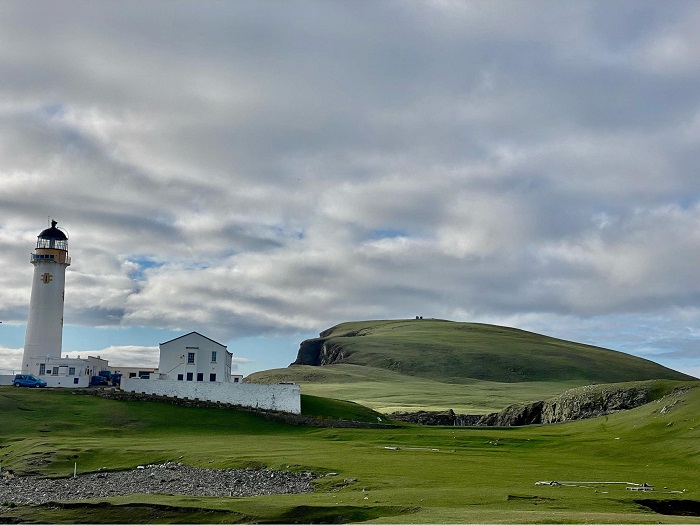
Fair Isle South Lighthouse is an active lighthouse situated on Fair Isle, between Orkney and Shetland. It was established in tandem with a second lighthouse (Fair Isle North Lighthouse) in 1892, in order to guide ships past the island.
Fair Isle is the most remote inhabited island in the British Isles, lying about 24 miles south-west of Shetland and 27 miles north-east of Orkney. Before the construction of the two lighthouses, it was hazardous to shipping due to its isolated location and the often powerful strength of storms in the area.
Both the South and North Lighthouses were engineered by David and Charles Stevenson. The machinery and equipment used at the two were both very similar, however the South Lighthouse was built much taller than its twin, as the North Lighthouse stands on 215 foot cliffs. The original light in the South Lighthouse used a paraffin lamp, which was turned using a geared mechanism powered by a descending weight suspended from a rope.
During World War II, the South Lighthouse came under attack by German aircraft in December of 1941. The wife of an assistant lighthouse keeper was sadly killed in the attack, while her infant daughter was injured. Just six weeks later, a second attack was initiated, with two bombs being dropped on the lighthouse. The first was a direct hit on the western end of the keepers’ cottages, resulting in the deaths of the wife and daughter of the principal lighthouse keeper. The main building subsequently caught fire and completely burned out.
Roderick Macaulay, who at the time was assistant lighthouse keeper at the North Lighthouse, walked the 3 miles to the South Lighthouse to lend a hand in restoring it to operational order. He battled through snowdrifts and gale-force winds in the process, and was awarded a British Empire Medal (BEM) for outstanding services as a result. A plaque in memory of those lost at the lighthouse during the war was erected at the South Lighthouse in 1998.
As there is no mains electricity on Fair Isle, the lighthouse was powered by diesel generators for a time, but now runs on renewable power. It was automated in 1998, becoming the last Scottish lighthouse to be relieved of its keepers.
Fair Isle South Lighthouse has a cylindrical, masonry tower which stands 26 metres (85 feet) high. It is a Category B listed building and its light has a range of 22 nautical miles.
Out Skerries Lighthouse, Shetland
Out Skerries Lighthouse is an active lighthouse built on Bound Skerry, a small island which is part of the Out Skerries archipelago, in Shetland. The lighthouse was established in 1858 to guide ships passed the islands.
Made up of numerous islets, rocks and sea stacks, Out Skerries poses a great many hazards to mariners, which have contributed to the loss of countless ships over the years. The first structure aimed at preventing further loss of life was a temporary one erected on Grunay – one of the largest of the Out Skerries group – in 1854. This was done at the request of Her Majesty’s Navy to protect ships engaged in the Crimean War.
Four years later, after the war had ended, the current lighthouse was built as a more permanent aid to navigation. Designed by David and Thomas Stevenson, it was built on the eastern-most islet in Shetland – Bound Skerry. Accommodation for the lighthouse keepers was not provided at the station directly, with personnel living on neighbouring Grunay instead.
Out Skerries was of strategic significance during World War II due to its relative proximity to Norway (Bound Skerry is less than 200 miles from the Norwegian coast). Many boats from Norway arrived at Out Skerries, carrying people fleeing the Nazi occupation. German troops were aware of this activity and also suspected that there was a munitions factory on the islands, leading to the lighthouse station suffering various attacks from German aircraft.
The lighthouse shore station was machine-gunned in February 1941, before a German bomber attacked the shore station in January 1942. Two bombs were dropped initially, both of them 3. Forelandmissing, but the aircraft circled around and dropped a third, which struck the Boatman’s House. The house was destroyed, resulting in the death of Mary Anderson, the Boatman’s mother. As a result of this, the island of Grunay was evacuated. Later in the war, a Canadian bomber crashed on Grunay and all three crew were killed.
The lighthouse at Out Skerries was automated in 1972. It has a cylindrical stone tower, which is painted white and reaches 30 metres (98 feet) high. The building is Category B listed and the light has a range of 20 nautical miles, producing a white flash every 20 seconds.
Muckle Flugga Lighthouse, Shetland
Muckle Flugga Lighthouse is an active lighthouse located on the island of Muckle Flugga, in Shetland. It was built in 1854 to warn ships of the island’s presence.
Muckle Flugga is is the second most northerly point in the British Isles, beaten only by the islet of Out Stack, which lies slightly further north. A lighthouse had been considered on Muckle Flugga as early as 1851, but the topography of the small island had made it difficult to determine a suitable site. As a result, nothing was done until the Northern Lighthouse Board were urged to establish a light by the Government due to Her Majesty’s ships requiring safe passage during the Crimean War.
A temporary light was therefore established, built in just 26 days. As it was situated on rocks 200 feet above sea level, it was thought that the lighthouse would be safe from the ocean. However, it was quickly found that winter storms would churn up waves so large that they broke heavily on the lighthouse and would force open the door to the keepers’ dwellings, soaking everything.
Plans for a permanent and higher light were put in place, although there was some disagreement over whether it should be established on Muckle Flugga or on nearby Lamba Ness. It was eventually decided that Muckle Flugga would be the site and the new lighthouse was completed in 1858. Engineered by Thomas and David Stevenson, the lighthouse was a challenging build, requiring foundations sunk ten feet down into the rock. Construction came to a total cost of £32,000.
Although initially having a fixed light, it was decided in 1927 that the character should be changed to group flashing, due to fixed lights being considered no longer suitable. For many years, the keepers’ dwellings were very rudimentary, with those stationed having to sleep in what was described as a “crow’s nest”. That was addressed in 1968, with a new dwelling block being built in a space freed up when the lighthouse was electrified.
Three lighthouse keepers were stationed at Muckle Flugga at any one time, with each spending one month on the rock followed by one month onshore. During bad weather, it sometimes took many days before a boat could reach the island, so a helicopter landing pad was established alongside the lighthouse.
Muckle Flugga Lighthouse has a cylindrical masonry tower which stands 20 metres (66 feet) high. It is a Category A listed building and the light has a range of 22 nautical miles. It flashes twice every 20 seconds.
Hoy High Lighthouse, Orkney
Hoy High Lighthouse, also known as Graemsay Island Rear Lighthouse, is an active lighthouse located on Graemsay Island, part of the Orkney Isles. It was built in 1851 to aid the navigation of ships through Hoy Sound and to mark the main channel into Scapa Flow Harbour.
The waters of Hoy Sound and Scapa Flow have long been significant for their role in trade and national security. With Scapa Flow chosen as a naval base in both the First and Second World Wars, it is famed for the deliberate scuttling of the German fleet at the end of WWI.
In 1851, a pair of lighthouses – Hoy High and Hoy Low – were established at the two northern points on Graemsay Island, which lies to the west of Scapa Flow. Both lighthouses were designed by Alan Stevenson and commissioned by the Northern Lighthouse Board. They were established largely to protect the activity of herring fisheries in the region. The High Light was built 33 metres tall, while the Low Light was built 12 metres tall, with the two designed to function as leading lights.
Accommodation for three lighthouse keepers was built attached to the High Light, along with a courtyard wall. This was originally much higher than it is now, but had to be lowered due to frequent damage sustained during powerful storms. The Low Light is attached to a coastal defence battery, which was built during WWII to guard the entrance to Scapa Flow.
Very little information exists about the changes and improvements made to the two lighthouses over the years, however it is known that the High Light was automated in 1978. It has an occulting red and white light which flashes every 8 seconds, while the Low Light has a white isophase light which flashes once every 3 seconds, distinguishing it from its sister light.
Hoy High Lighthouse has a cylindrical stone tower, which is painted white with ochre trim and stands 33 metres (108 feet) high. It is a Grade II listed building. The white light has a range of 20 nautical miles, while the red light is visible for a slightly shorter distance of 16 nautical miles.
Sule Skerry Lighthouse, Orkney
Sule Skerry Lighthouse is an active lighthouse found on Sule Skerry, a remote islet situated off the north coast of Scotland. It was built in 1895 to warn ships of the surrounding rocks and is notable for having been the most remote manned lighthouse in the UK up until its automation.
Sule Skerry lies about 40 miles west of Orkney and 35 miles north of the Scottish mainland. The islet covers around 35 acres and there is no land in sight from it other than one small neighbouring rock. However, it lies right in the passage of ships travelling from the Pentland Firth to Iceland and vice versa. As a result, the Northern Lighthouse Board decided to establish a lighthouse on the islet in 1892.
The remote location made construction difficult, especially in poor weather conditions. Winter work was ruled out as an option for this reason, together with the lack of light. This meant the lighthouse was built over the period from 1892 – 1895, with engineering work by David and Charles Stevenson. Landing places for boats and a small tramway for transporting rocks were also required.
The tower was topped with an exceptionally large lantern measuring 16 feet in diameter, which was larger than any other developed for a lighthouse at the time. It was made to accommodate a powerful ‘Hyper-radial’ lens. Illumination of the light was however delayed for a year, due to disagreements between the commissioners of the board and Trinity House over the cost of the lighting equipment.
Surprisingly, the isolation of the lighthouse led to pigeon post being briefly tried as a way of communicating between the station and the mainland, however this was not found to be successful. The remote location also led to occasional problems carrying out the monthly relief of the lighthouse keepers, who would sometimes find themselves stuck for days at a time due to bad weather.
The original light was later replaced with a gas light with a fourth order lens, and a helicopter service was implemented as a way to relieve the lightkeepers from 1973. This continued up until the lighthouse was automated in 1982.
Sule Skerry Lighthouse has a cylindrical masonry tower, measuring 27 metres (89 feet) in height. The Grade A listed building is painted white and is solar powered, with the light having a range of 21 nautical miles.
Butt of Lewis Lighthouse, Outer Hebrides
Butt of Lewis Lighthouse is an active lighthouse located at the northern tip of the Isle of Lewis, in the Outer Hebrides. It was established in 1862 to aid the navigation of ships past the northern regions of the island.
The Butt of Lewis is said to be the windiest part of the British Isles, according to the Guinness Book of World Records. This can make the surrounding waters difficult for shipping, especially during the winter. The lighthouse was engineered by David Stevenson and construction was finished in 1862.
Little is known about the station from this time. It is thought that the first light exhibited from the tower was fixed rather than flashing, though this is not certain. Stevenson is reported to have requested a flashing light, in order to distinguish the Butt of Lewis Lighthouse from the one at Cape Wrath, however the Department of Trade overruled him.
The early light was fuelled using either vegetable or fish oil, and this continued until 1869, when the more efficient paraffin was used instead. This was used as the fuel source for the light for over 100 years afterwards, until the station was electrified in 1976.
Prior to this, there had been a change to the light’s character and equipment. The current equipment was installed in 1905, as proven by a plaque which is present in the lightroom. The fixed light was altered so that it would flash – a characteristic achieved by installing a clockwork mechanism which revolved around the lens, obscuring it so that it flashed once every 20 seconds. The lighthouse keepers had to wind the clockwork motor every 30 minutes to keep it turning.
Three lighthouse keepers were stationed at the lighthouse at any one time while it was manned, with the attached dwellings accommodating them and their families. During the 1930s, the station was the main radio link for the lighthouse keepers on the Flannan Isle Lighthouse, which lies in an isolated spot west of Lewis. Nowadays, it has similarly important roles, acting as the monitoring station for several offshore lighthouses in the area, including the Flannan Isle light.
The Butt of Lewis Lighthouse was automated in 1998, becoming one of the last in Scotland to see its keepers leave. It has a cylindrical red brick tower, which is unusual in Scotland and therefore gives it a very distinctive appearance. The building is Category A listed and the tower stands 37 metres (121 feet) high. The light has a range of 21 nautical miles.
Flannan Isle Lighthouse, Outer Hebrides
The Flannan Isle Lighthouse is an active lighthouse located on the island of Eilean Mòr, one of the Flannan Islands situated west of Lewis. It was built in 1899 to warn ships of the islands’ presence, and is most famous for the mysterious disappearance of its keepers in 1900.
Construction of the lighthouse took place over a four year period from 1895, with the station being designed by David Stevenson. Due to the steep nature of the cliffs leading up to the site from the boat landing areas, construction was difficult, although later on a cable-hauled railway was established to help transport paraffin and other supplies.
Three lighthouse keepers were stationed at the light, however something very strange happened just a year after the lighthouse was first lit. On 15 December 1900, a passing vessel noted that the light was not displayed, later informing the Northern Lighthouse Board. A relief vessel could not be sent to investigate for several days due to poor weather, but it eventually arrived at the lighthouse on 26 December. Onboard, was relief keeper, Joseph Moore.
Moore landed on the island and went to assess the situation, but found the station to be completely deserted. All three lighthouse keepers had vanished. On further inspection, the light was found to be ready for illumination and the last written entries for the keeper’s log had been made on 13 December.
No bodies were ever found and many theories have been put forward to explain what happened, with some citing kidnap, murder or even ghosts as possible causes of the disappearance. The Northern Lighthouse Board’s investigation concluded that the three keepers probably left the light to secure some equipment on the island’s western cliffs, and had been washed off the island by a large wave. But to this day, it remains one of the great mysteries of the British coast.
In 1925, the lighthouse became one of the first Scottish lighthouses to receive communication by wireless telegraph. The railway was removed in 1960 and the lighthouse was automated in 1971, with a helipad being installed at the same time to allow for maintenance visits.
The Flannan Isle Lighthouse has a cylindrical masonry tower that is 23 metres (75 feet) high. Its third order Fresnel lens has a range of 20 nautical miles and the building is Category B listed.
Eilean Glas Lighthouse, Outer Hebrides
Eilean Glas Lighthouse is an active lighthouse situated on the island of Scalpay, south-east of Lewis in the Outer Hebrides. It was established in 1789, making it one of the original four lighthouses built in Scotland, and was designed to warn ships of the island’s presence.
The Northern Lighthouse Board approached the owner of Scalpay in 1787, seeking to build a light on the island’s eastern coastline. Captain Alex McLeod, who was owner at the time, accepted the proposal and made his own arrangements to begin building the foundations for the lighthouse while the Board’s masons were busy working on the Mull of Kintyre Lighthouse.
The Board’s masons arrived at Scalpay a year later, with engineer Thomas Smith finding that McLeod’s workmen had made the circumference of the lighthouse tower’s base four feet greater than was originally planned. To save time and money, it was decided that construction at this slightly larger scale would go ahead and the light was first lit in October of 1789. This original tower did not last long however, and was replaced by a new tower (the current lighthouse) in 1824.
The new tower was engineered by Robert Stevenson and was accompanied by new keepers’ cottages and a new access road from the pier. The height of the old tower was reduced at the same time, to reduce any potential interference with the beam of the new light. Though initially a fixed light, it was changed to a revolving lens system in 1852. The old lens was given to the Royal Scottish Museum for public display.
A fog signal station was installed at the site in 1907, with the light being upgraded to a flashing light at the same time. The fog signal let off a blast for 7 seconds every minute and a half during foggy conditions. It functioned up until 1987, when it was discontinued. A few years prior to this, the lighthouse had been automated, with its keepers leaving for the last time in 1978.
Eilean Glas Lighthouse was recently refurbished in 2019, with the sealed beam lamp being upgraded to an LED optic. The lighthouse has a distinctive appearance, with its 30 metre (98 feet) tall masonry tower having been painted with red horizontal stripes to ensure it can be used as a day mark. The building is Category A listed and the light has a range of 18 nautical miles.
Ornsay Lighthouse, Inner Hebrides
Ornsay Lighthouse is an active lighthouse located on Ornsay – a small tidal island just off the east coast of the Isle of Skye in the Inner Hebrides. It was built in 1857 to guard the approach to the Sound of Sleat.
The decision to build the lighthouse at Ornsay was made as part of a larger plan to establish a system of lights around the coastlines of Scotland in the mid-nineteenth century. David Stevenson, who at the time was engineer at the Northern Lighthouse Board, made a list of 45 possible sites for the lighthouses. Of these, Ornsay was one of eight to be given priority, and was engineered by Thomas and David Stevenson.
Ornsay Lighthouse was completed in 1857 and lighted at the same time as four other lighthouses in north-west Scotland (Rubha nan Gall, Kyleakin, Rona and Ushenish). Ornsay was given a new condensing apparatus, which was introduced by Thomas Stevenson as an improvement to the dioptric lighting system. Shown in different directions, the condensed light varied in strength according to the distance it was required to be seen.
It was converted to gas operation in 1898 and was automated in 1962. The keepers’ cottages were sold a few years later and converted to holiday cottages, which they remain to this day. The lighthouse was later modernised in 1988, with the gas system converted to one that ran on mains power.
The current optic system includes a 250 watt tungsten lamp controlled by an electronic flasher. There is an emergency lamp within the lightroom which is automatically selected in the event of any failures within the main light. Ornsay Lighthouse is currently not monitored by the Northern Lighthouse Board’s headquarters, unlike most other Scottish lighthouses. Instead, it relies on an observer to report any problems.
The lighthouse has a cylindrical, masonry tower that stands 19 metres (62 feet) high. The building is Category B listed and is painted white with a black lantern and ochre trim. The light has a range of 12 nautical miles and is occulted once every eight seconds.
Ardnamurchan Lighthouse, Argyll & Bute
Ardnamurchan Lighthouse is an active lighthouse found on the Ardnamurchan Peninsula, in Lochaber. The lighthouse was built in 1849 to provide safe passage for ships passing the peninsula.
The lighthouse sits on the most westerly point of the British mainland, with views out towards some of the Inner Hebrides. This site was chosen by the Northern Lighthouse Board in 1845, who purchased a 20 acre piece of land for the price of £20. Alan Stevenson was engineer during the lighthouse’s construction and the building process took about three years, with interruptions after the workers suffered an outbreak of scurvy.
Unusually for a Scottish lighthouse, it was built using pink granite, and in fact Ardnamurchan Lighthouse was one of the last stone towers to be built by the Northern Lighthouse Board. The original fixed light was fuelled by oil and was first lit in October of 1849, but was upgraded to a flashing light in 1928.
Two lighthouse keepers were stationed at the site, with both being paid £18 per year for their services. Various livestock were kept in the fields surrounding the lighthouse in its early years. In 1852, the tower was struck by lightning in a severe storm, resulting in a few broken glass panes and damage to some of the tower walls. The storm also blew down some of the perimeter wall and 40 feet of road was washed away by heavy seas.
A foghorn signal station was active at the lighthouse for a time, but this has since been decommissioned. The fog station remains however, and provides a spectacular viewpoint of the surrounding coastline.
Mains electricity was installed at the lighthouse in 1976 and the light was automated in 1988. After the departure of its keepers, the Board decided to sell off some of the redundant buildings at the complex. These are now privately operated as the Ardnamurchan Visitor Centre, with a small museum dedicated to the history of the lighthouse.
Ardnamurchan lighthouse has a granite, cylindrical tower which is unpainted and light grey in colour. The tower stands 36 metres (118 feet) high and the building is Category A listed. The light has recently been upgraded to LED functioning and has a range of 18 nautical miles. It flashes twice every 20 seconds.
Lismore Lighthouse, Inner Hebrides
Lismore Lighthouse is an active lighthouse situated on the small island of Eilean Musdile, which lies next to the larger island of Lismore, at the entrance to Loch Linnhe. It was built in 1833 to aid the navigation of ships into Loch Linnhe and between the mainland and the Isle of Mull.
Construction of the lighthouse began after the Northern Lighthouse Board purchased the island of Eilean Musdile from a local landowner for the sum of £500. Robert Stevenson was engineer for the project and the lighthouse was built by the contractor James Smith from Inverness, who worked on a number of lighthouses for the Board. The light was first exhibited in October of 1833.
At the time, the light was extremely useful, as it opened up the Firth of Lorne and Loch Linnhe, which lead to the western entrance of the Caledonian Canal. It was also of great use to vessels navigating the sounds of Mull, Luing and Islay.
Lismore Lighthouse was staffed by four lighthouse keepers at a time, who each spent six weeks on the island before having two weeks off on the mainland. The light was initially a fixed white light, but was soon changed to a flashing one. Many of the Northern Lighthouse Board’s lights were changed to dioptric or Fresnel lenses in 1910, but Lismore – together with Fidra in the Firth of Forth – remained as the only two catoptric lights.
Although it was initially proposed that communication to and from the lighthouse could be improved by way of building a road bridge connecting Eilean Musdile to Lismore, this plan was abandoned after a small bridge was built instead across a gorge which segments Eilean Musdile.
During the Second World War, two lighthouse keepers at Lismore set off in difficult conditions to rescue two airmen whose aircraft had crashed into the waters offshore, leaving them clinging to wreckage. The rescue effort was successful.
Lismore Lighthouse was radically altered in 1965, with the light being automated at the cost of £10,000 and the lighthouse keepers leaving for the last time. Several tons of building material were transported from nearby Oban in the process.
The lighthouse is a cylindrical, masonry tower painted all in white, standing 26 metres (85 feet) high. The building is Category A listed and the 71,000 candela light has a range of 17 nautical miles.
Skerryvore Lighthouse, Inner Hebrides
Skerryvore Lighthouse is an active lighthouse on a remote reef about 11 miles south-west of the island of Tiree, in the Inner Hebrides. Built in 1844, it warns ships of the rocks and is most notable for being the tallest lighthouse in Scotland.
During the late 18th and early 19th centuries, many ships were wrecked on the Skerryvore reef and the need for a lighthouse was clear. However, the section of reef above water was small, rocky and highly exposed to wind and waves. Construction was a monumental task and the Northern Lighthouse Board delayed for many years, daunted by the potential costs. Eventually, in 1838, construction began, with Alan Stevenson as engineer.
A temporary wooden structure was built on the reef to house the workers, though this had to be replaced in the first year after being destroyed by a severe gale. Stevenson and his men were only able to work during the calmer summer months, but made up for this by often working gruelling 17 hour days. Although slow, the rest of the construction process went largely without incident and the lighthouse was first lit in February of 1844.
No lives were lost during construction, despite the dangers, and the lighthouse was an incredible achievement for both Alan Stevenson and the Board. It had a revolving dioptric light which, at the time, was the most advanced in the world.
The light shone uninterrupted for 110 years, until the lighthouse suffered a terrible fire in 1954. The fire began on the seventh floor and spread downwards, forcing the lighthouse keepers out onto the rock in the middle of the night and badly damaging the light. The keepers were left stranded, but luckily a relief vessel was already scheduled to arrive the following day and they were rescued unharmed.
Temporary lights were set up during reconstruction of the main light and tower. The process took three years, with the Board deciding to electrify the lighthouse at the same time. The light was re-established in August of 1959 and a helicopter landing pad was installed at the base of the tower in 1972, to make lighthouse keeper changeovers easier. The lighthouse was automated in 1994.
At 48 metres (157 feet) tall, Skerryvore Lighthouse is the tallest lighthouse in Scotland and one of the tallest in the UK. It has a grey, masonry tower which tapers towards the top – a feature which has led to it being regarded as one of the most elegant lighthouses in the world. It is a Category A listed building and the light has a range of 23 nautical miles
Dubh Artach Lighthouse, Inner Hebrides
Dubh Artach Lighthouse is an active lighthouse located on Dubh Artach – a remote skerry found about 15 miles south-west of the Isle of Mull. The lighthouse was established in 1872 to warn ships of the rocks.
The rocks of the reef lie in an open stretch of water between the islands of Colonsay, Mull and Islay. In the 19th century, many ships passed through this region on journeys to North America or the Baltic nations, and the rocks represented a real danger. A number of ships were wrecked on the reef over the years, and it was hoped the establishment of a light would allow vessels to traverse the region safely.
Construction on Dubh Artach was expected to be extremely difficult, but engineers Thomas and David Stevenson took up the challenge. Winter work was ruled out completely, yet it was even difficult to land on the island during summer. Therefore, a temporary structure was first built on the rock to accommodate the workers, just as had been done for the Bell Rock and Skerryvore Lighthouses. Conditions were poor and work was slow, but construction was eventually completed in 1871, with the lighting equipment being installed the following year.
When it was first lit, the Dubh Artach Lighthouse was the first isolated rock light to use paraffin. In fact, the light was so bright that the principal lighthouse keeper, James Ewing, reported that the keepers’ eyes were being adversely affected. Ewing looked after the lighthouse for eleven years in total, having much more of a taste for the extreme conditions than some of his colleagues. One reportedly had to be stopped from diving into the sea and swimming to shore on one occasion, after growing fed up with the hardship.
Incredible waves measuring 28 metres high were experienced at the station in some cases, with the area renowned for its high seas during winter. The remote location and cramped living conditions warranted extra pay for the keepers.
The lighthouse was painted with a horizontal red band in 1890 to distinguish it from the nearby light at Skerryvore. It was automated in 1971 and a helipad was installed at the site the year after, to ensure that it was easier to land on the rock to carry out maintenance work.
Dubh Artach Lighthouse is a cylindrical, slightly tapered granite tower, which stands at a height of 38 metres (125 feet). It is a Category A listed building and the light has a range of 20 nautical miles.
Ruvaal Lighthouse, Inner Hebride
Ruvaal Lighthouse, also known as Rubh’a’ Mhàil Lighthouse, is an active lighthouse located on the north-eastern tip of the island of Islay, in the Inner Hebrides. It was built in 1859 to mark the northern approach to the Sound of Islay.
The need for a lighthouse at this end of Islay was first proposed by Robert Stevenson as early as 1835, though it was many years before plans to build a lighthouse were enacted. The Board of Trade requested that the lighthouse should cast its beam as far as the Neva Rocks, which lie many miles west of the station. As a result, it was calculated that the tower had to be built to at least 100 feet in height.
The lighthouse was designed by David and Thomas Stevenson, and cost £6,500 to build, with the light first illuminated in January of 1859. When it was first lit, the light was fixed and had a second class dioptric lens. Though the lighthouse tower is rather impressive, the architecture of the keepers’ cottages was criticised in an 1861 report for looking “more like dog kennels than anything else”.
Ruvaal Lighthouse is very remote, and in its early years it was only accessible by boat or by a trek of several miles across rough, boggy landscape. This often made it difficult to relieve the lighthouse keepers of their duties during bad weather. Helicopter reliefs were introduced in 1981 for this reason, a decision which was likely welcomed by the keepers.
In February of 1981, a mains power line was installed at the station, running out to Ruvaal from Bunnahabhainn. During the work, a helicopter was brought in to help land the electricity poles. It successfully landed the first two, but when attempting to land the third, the main rotor struck the pole and was completely destroyed. The helicopter crashed, but the pilot had a lucky escape.
The power line was eventually finished, and the electricity supply meant a new lighting system could be installed at Ruvaal, formed of a catadioptric sealed beam lamp array, which was completed in 1982. The lighthouse was automated the following year, with the keepers’ cottages being sold.
Ruvall Lighthouse now stands above a well-maintained garden and is often visited by red deer. The lighthouse has a cylindrical white tower that reaches 34 metres (112 feet) high. The building is Category B listed and the light has a range of 19 nautical miles.
Mull of Kintyre Lighthouse, Argyll & Bute
The Mull of Kintyre Lighthouse is an active lighthouse situated on the Mull of Kintyre – the tip of the Kintyre Peninsula in south-western Scotland. The lighthouse was established in 1788 to aid the navigation of ships around the peninsula.
It was the second lighthouse to be established by the Northern Lighthouse Board, preceded by the light at Kinnaird Head. One of the factors in the decision to locate the light on the Mull of Kintyre was the wrecking of two large fishing vessels at the point during storms a few years earlier, which resulted in many lives lost.
Engineered by Thomas Smith, with the assistance of a young Robert Stevenson, the light was first lit in November of 1788, after a 22 month construction process. The primary reason why the lighthouse took so long to build was the terrain on which the site lay. Located on high cliffs, miles from any road, the lighthouse was inaccessible by sea and extremely difficult to get to on foot. Instead, materials had to be landed 6 miles up the coast and carried over the rough terrain on horseback.
Many changes have taken place at the Mull of Kintyre Lighthouse since it was built, and in fact the station was rebuilt between 1821 and 1830. This was done as a way of establishing it as a more permanent station. As the sea around the Mull of Kintyre is often affected by fog, the station was one of the earliest recipients of a fog signal in 1876. However, this installation was not enough to prevent a paddle steamer from running aground on the point in dense fog in 1895. All onboard were thankfully saved, though the ship sank the following day.
The light, which for many decades was a simple fixed light, was changed to a flashing light in 1906. At this time, its power was also increased significantly, from 8,000 to 281,000 candlepower. It was later electrified and had its strength further increased to over 1.5 million candlepower in 1976. The new lighting apparatus was formed of an electric filament lamp with a catadioptric lens. The light was automated in 1996.
The Mull of Kintyre Lighthouse has a cylindrical brick tower, which is painted white and only stands 12 metres (39 feet) tall, due to it being situated on 240 foot cliffs. The building is Category A listed and the light has a range of 18 nautical miles.
Corsewall Lighthouse, Dumfries & Galloway
Corsewall Lighthouse is an active lighthouse located on the northern tip of the Rhinns of Galloway, near Stranraer. Established in 1817, the lighthouse ensures the safety of ships passing through the north channel of the Irish Sea, and guides vessels into Loch Ryan.
The first calls for a lighthouse in the area came in 1814, when an application was made to the Trade of Clyde for a light to be established at Corsewall Point. The Northern Lighthouse Board inspected the site and found it to be suitable, with construction beginning in 1815. Robert Stevenson was engineer for the project, and upon his inspection visit in December of 1815 he found that the construction process was going well and that the first stage of the tower and part of the keepers’ accommodation were being built.
Construction was finished in 1816, though the lighthouse was not lit until the following year. The original light was fuelled by oil and was part of a revolving apparatus which displayed a light alternating between white and red. This was one of the first such lights to appear in Scotland. The initial reflectors used were so powerful that they needed to be covered during the day to prevent spontaneous combustion.
In the lighthouse’s first year, there was an incident of negligence involving the principal lighthouse keeper, where he is reported to have fallen asleep on the job, resulting in the revolving light coming to a halt for a period of time. The Board suspended him from Corsewall and sent him to the Bell Rock Lighthouse, to serve as assistant lighthouse keeper instead.
Corsewall Lighthouse was modernised in 1891 and 1910. It suffered minor bomb damage in 1941, when it was attacked by enemy aircraft during World War II. Minor damage was also reportedly caused in 1970 when Concorde flew over the lighthouse on a trial flight, resulting in a few broken panes of glass. The aircraft made several flights over the lighthouse in the following years, with no further incidents.
The lighthouse was automated in 1994 and the former keepers’ accommodation was sold. Although the Northern Lighthouse Board still control the light, much of the building now forms the Corsewall Lighthouse Hotel.
Corsewall Lighthouse has a 34 metre (112 foot) cylindrical tower, which is painted white and is topped by a balcony and lantern. The former keepers’ cottages are two-storeys high. The building is Category A listed and the light has a range of 22 nautical miles.
Rathlin Island West Lighthouse, County Antrim
Rathlin Island West Lighthouse is an active lighthouse situated on Rathlin Island, off the north coast of Northern Ireland. It was established in 1919 to aid the navigation of ships around the western part of Rathlin, and is most notable for being a rare example of an ‘upside down’ lighthouse.
Although Rathlin West Lighthouse was established in 1919, the suggestion of a lighthouse being built on this part of Rathlin was made as early as 1901. There were initial disagreements between Trinity House and the Commissioners of Irish Lights (the general lighthouse authority for Northern Ireland) over which headland was more suitable for a lighthouse, either Bull Point or Crockantirrive. But after a few experiments it was decided that the 300 foot high cliffs at Crockantirrive would be better.
Several years elapsed before building work began, and progress was slow even when it did. The somewhat awkward location of the site meant that an inclined railway and jetty needed to be built at nearby Corraghy to land materials. The supplies were then carried by horse and cart to the construction site. In addition, hundreds of tons of concrete were poured and set against the cliffs to facilitate access to the lighthouse.
Construction was eventually completed in 1916, but the light was not operational until March of 1919. The initial light was fuelled by paraffin and flashed red every five seconds. A fog signal station was installed at the site in 1925, nicknamed the ‘Rathlin Bull’, which could be heard around 20 miles away.
Three lighthouse keepers were stationed at the lighthouse while it was manned, with duties being rotated every six weeks with Rathlin Island East Lighthouse. The light and fog signal were electrified in 1982, with the lighthouse being automated the following year. The fog signal was permanently discontinued in 1995.
Rathlin West Lighthouse is now remotely monitored by Irish Lights from its sister lighthouse on the east and is only exhibited during the day when visibility is poor. It has a white cuboidal tower which, unusually, has the lantern sitting at its base, giving it the appearance of being upside down. The tower is 18 metres (59 feet) tall and the red light has a range of 22 nautical miles.
East Maidens Lighthouse, County Antrim
East Maidens Lighthouse is an active lighthouse situated on one of the Maidens – a group of islets and skerries in the North Channel of the Irish Sea, several miles off the Northern Irish coast. The lighthouse was built in 1829 to warn ships of the rocks.
The East Maidens lighthouse was built as one of a pair of lighthouses, with the second being a smaller light known as the West Maidens Lighthouse. The recommendation of two lights was made by Inspector of Lighthouses George Halpin, after requests for a light had been made by local merchants. Halpin designed and oversaw the construction of both lights, which were located 800 yards apart on two of the larger islets within the group.
The lighthouse keepers and their families lived on-site at both stations in the early years, and there is a tale involving a love story between the assistant keeper at one lighthouse and the daughter of the keeper at the other. They often visited each other by boat until the two families fell out, after which the woman’s father forbade them from seeing each other. Unwilling to be separated, the couple snuck off to the mainland and eloped to Carrickfergus.
In 1889, an additional light was built into one of the windows of East Maidens Lighthouse to illuminate the Highland Rocks. Shortly afterwards, it was proposed that a light vessel with a foghorn could be stationed at the Highland Rocks, and that the West Maidens Light could be discontinued. This idea never came to be, however the west light was eventually abandoned in 1903, after the East Maidens Lighthouse received an upgrade.
East Maidens Lighthouse then spent a period as a combined station with the Ferris Point Lighthouse, with one principal keeper responsible for both lighthouses. This was the case from 1906 to 1951, when the Maidens Lighthouse received its own principal keeper.
With advancing technologies, an electric light was installed at the Maidens Lighthouse in 1977 and this paved the way towards automation. The lighthouse keepers were withdrawn permanently less than a month later, with the accommodation buildings being demolished shortly afterwards. The station is now looked after by an attendant and the light is monitored remotely by the Commissioners of Irish Lights.
East Maidens Lighthouse is a cylindrical, stone tower which is white with a black horizontal band. The tower stands 23 metres (76 feet) tall and the light has a range of 23 nautical miles.
Black Head Lighthouse, County Antrim
The Black Head Lighthouse is an active lighthouse found at the northern end of Belfast Lough, in County Antrim. The light was established in 1902 to aid the navigation of ships approaching Belfast Harbour.
The first application for a light at Black Head was made in 1893, by the Belfast Harbour Board. However, this was rejected by the Commissioners of Irish Lights as they were reluctant to allocate funds for a light which would only benefit Belfast. A second request five years later was also turned down, but a subsequent agreement between the Board of Trade and Trinity House ensured that funds would be provided for a lighthouse and fog signal.
The lighthouse was designed by Irish Lights engineer, William Douglass, with the construction contract awarded to William Campbell and Sons. Work began in 1899 and the light was first exhibited in 1902, in combination with an explosive fog signal station.
Black Head Lighthouse was built during the hay day of the Belfast shipping industry, and it guided many significant ships through Northern Irish waters, including the ill-fated Titanic, which was built in Belfast in 1911.
The original lighthouse tower was painted red, but this was changed to a more classical white in 1929. The station received a number of improvements in 1965, when the lighthouse was electrified and the intensity of the light was increased to give it a greater range. The explosive fog signal also saw a change, with the addition of a bright flash of light being emitted when it sounded during darkness.
The fog signal was eventually discontinued in 1972, a few years before the lighthouse was automated and its keepers withdrawn in 1975. A part-time attendant has since been in charge of looking after the station, while the former keepers’ accommodation has been turned into holiday accommodation. The original whistle pipe system used to wake up off duty keepers and call them to work remains in place.
Black Head Lighthouse has an octagonal tower which is 16 metres (52 feet) high and topped by a large lantern and gallery. The building complex is Category B listed and the lighthouse is designated as one of the “Great Lighthouses of Ireland”. The catadioptric annular lens produces a light with an impressive range of 27 nautical miles, and a character of a single white flash every 3 seconds.
Mew Island Lighthouse, County Down
The Mew Island Lighthouse is an active lighthouse built on Mew Island, one of the Copeland Islands off the north-east coast of County Down. The lighthouse was constructed in 1884 to guide ships around the islands and in and out of Belfast Lough.
The Mew Island light was not the first lighthouse to appear on the Copeland Islands, with the earliest example being built in 1711. This was formed of a three-storey tower topped with a coal-fired brazier, which was later replaced by a glass-paned lantern with six Argand lamps, fuelled by sperm whale oil.
In 1810, responsibility for lighthouses around Ireland passed to what is now the Commissioners of Irish Lights. They decided to replace the first lighthouse with a more powerful light, designed by George Halpin, which was completed in 1815 and known as the Copeland Island Lighthouse. However, despite the presence of these lighthouses, there were several notable shipwrecks around the islands during the first half of the 19th century. This was primarily due to the waters surrounding the islands having very strong tidal currents.
As shipping traffic in and out of Belfast Harbour began to ramp up, it became clear that a larger, more prominent lighthouse was required on the islands. In 1875, the Belfast Harbour Commissioners requested that the Copeland Island light be removed and replaced with a lighthouse on Mew Island. Work began in 1882, engineered by William Douglass, and the Mew Island Lighthouse was first exhibited in November of 1884. A fog signal was installed at the same time.
The light was the largest available at the time, formed of a first-order optic with 324 gas burners. The strength of the light could be varied depending on the number of burners used. The light suffered from a number of problems however, and in 1928 it was decided that a hyper-radiant optic installed at the Tory Island Lighthouse should be moved to the station at Mew Island instead. It was first lit using paraffin, but was changed in 1968 to run on electric power instead.
The hyper-radiant lens was in place at Mew Island Lighthouse for more than 85 years, until it was removed and replaced with a solar powered LED system in 2014. This change was criticised by some for being unnecessary.
The Mew Island Lighthouse has a stone tower, which is painted black with a white horizontal band and white lantern. The building is Category B listed and the tower stands at 37 metres (121 feet) tall. The light has a range of 18 nautical miles.
Donaghadee Lighthouse, County Down
Donaghadee Lighthouse is an active lighthouse which stands at the harbour in the seaside town of Donaghadee, in County Down. It was built in 1836 to guide ships into Donaghadee Harbour.
Just 22 miles separate Donaghadee from Portpatrick in Scotland, and this journey was a popular shipping route for 200 years, after its establishment in 1662. Although the route gradually declined as vessels got larger, it was key to the growth of Donaghadee and its harbour. With the rise of steam-driven ships in the early 19th century, the harbour facilities at Donaghadee were improved and its commissioners decided that a light should be established at the harbour entrance.
The harbour commissioners wrote a letter to the Ballast Board informing them of their plans, and after some deliberations the Board agreed to take charge of the light. Construction began in 1836 and was completed the same year, with the tower being built from cut limestone which, like much of the surrounding harbour, originated from quarries in Anglesey in Wales. The lighthouse was built by David Logan, an engineer who assisted Robert Stevenson in building the Bell Rock Lighthouse in Scotland.
The original light was established as a fixed one, exhibiting red light to the seaward direction and white light over the harbour. For several decades, there was no dwelling for the keeper of the Donaghadee Lighthouse, with them residing in a house rented by the Ballast Board instead. However a dwelling was built in 1864 at the end of the pier.
Although the lighthouse tower was originally unpainted and left to its natural grey colour, it was painted white with a black plinth sometime between 1869 and 1875. In May of 1990, a large fire broke out within the lighthouse and it suffered extensive damage, particularly to the optic and lantern. A temporary light was established while repairs were undertaken, and the light was restored in September of the same year.
The Donaghadee Lighthouse was electrified in 1934, becoming the first lighthouse in Ireland to run on electric power. At the same time, the character of the light was changed to isophase, flashing white every four seconds.
The lighthouse has a limestone tower which is fluted and stands at 16 metres (52 feet) tall. The white light has a range of 17 nautical miles, while the red light has a range of 13 nautical miles.
St. John’s Point Lighthouse, County Down
St. John’s Point Lighthouse is an active lighthouse situated on St. John’s Point, in south-eastern County Down. It was constructed in 1844 to aid the navigation of ships along Northern Ireland’s eastern coast and is notable for being the tallest lighthouse on the Irish mainland.
This part of the coastline had long been considered a particularly dangerous place for shipping, with St. John’s Point being surrounded by rocks and the adjacent bay of Dundrum featuring treacherous shifting sand banks. Some viewed Dundrum Bay as one of the most dangerous shipping bays in the region, and there was a clear need for a lighthouse as shipping traffic grew through the early 19th century.
Construction of the lighthouse at St. John’s Point was approved by the Ballast Board in 1839, with the station being designed by Inspector of Lighthouses, George Halpin. The light was established in May of 1844, after a delay to it being commissioned.
Despite the presence of the light, the dangers of the surrounding waters were brought to international attention in 1846, when the SS Great Britain ran aground in Dundrum Bay. At the time, the vessel was the longest passenger ship in the world, and had floundered after making a series of navigational errors shortly after embarking for New York. The ship was eventually re-floated the following year, at a substantial cost, and is now a museum ship in Bristol.
Although initially displaying a white light, the light was changed to red in 1860 and the lighthouse saw a number of improvements through the remainder of the 19th century. The height of the tower was increased, a fog signal was installed and an auxiliary light was put in place in one of the tower’s windows. This light was fixed and shone across Dundrum Bay.
In 1908, a Fresnel lens was installed and the previous gas jet burners were replaced with incandescent vaporised paraffin burners. The tower received its now distinctive colours in 1954, when it was painted black with two horizontal yellow bands, a feature which ensured it could be used as a day mark.
The auxiliary light was electrified in 1957, with the main light and fog signal following suit in 1981. Shortly afterwards, the station was automated and placed in the hands of part-time attendant.
St. John’s Point Lighthouse has a cylindrical, slightly tapering tower which reaches 40 metres (130 feet) high. The light has a range of 25 nautical miles.
Haulbowline Lighthouse, County Down
Haulbowline Lighthouse is an active lighthouse located at the entrance to Carlingford Lough, in County Down, at the southern-most point of Northern Ireland. Built in 1824, the lighthouse was established to warn ships of the rocky shoals at the entrance to the inlet.
A previous lighthouse had stood at Cranfield Point – which overlooks Carlingford Lough – since 1803. However, this was later judged to be poorly-positioned to warn of the various rocks and shoals that lie at the lough’s entrance, many of which are only visible at low tide. For this reason, the merchants of nearby Newry requested in 1817 that the lighthouse be replaced.
This request was accepted by the Dublin Ballast Board, and the decision was made to establish the new lighthouse on one of the wave-washed Haulbowline Rocks. Construction was therefore somewhat challenging, with the rock being submerged for large parts of the day and surrounded by fast-flowing currents. With engineering work by George Halpin, the light was first exhibited in September of 1824, praised as a “remarkable achievement”.
The main light was initially fixed, and the tower also displayed a secondary ‘half tide light’ from a balcony half way up. This was switched on whenever the tide allowed safe passage into Carlingford Lough, though it later became redundant after the lough was made deeper. In 1860, the poor location of the previous Cranfield Point Lighthouse was further highlighted, when it succumbed to coastal erosion and collapsed into the sea.
The main light at the Haulbowline station was changed from fixed to group occulting in 1899, and the original bell fog signal was changed to an explosive fog signal at about the same time. A few years later, the lighthouse was witness to the worst maritime disaster in Carlingford Lough’s history, when a coal ship collided with a passenger ferry in 1916, resulting in the deaths of 97 people.
Haulbowline Lighthouse was electrified and automated in 1965, becoming the first offshore Irish light to be made completely automatic. It received a range of upgrades in 1990, including an additional electric generator, an improved fog signal and a new optic. However, the new optic proved to be faulty and was later replaced.
Haulbowline Lighthouse has a cylindrical, tapered stone tower which stands 34 metres (112 feet) high. It is a Grade B+ listed building and is operated by the Commissioners of Irish Lights. The light has a range of 10 nautical miles, having recently had its range reduced.
Mull of Galloway Lighthouse, Dumfries & Galloway
The Mull of Galloway Lighthouse is an active lighthouse situated at the most southerly point of Scotland, at the end of the Rhins of Galloway peninsula. It was established in 1830 to provide safe passage for ships sailing past the point.
Construction began in 1828 and cost somewhere between £8,000 and £9,000, with engineering work by Robert Stevenson. The light was first exhibited in March of 1830. When it was first lit, the light was occulting, with two opaque shades used to obscure the light at fixed intervals.
A fog signal station was established near the lighthouse in 1894, powered for many years by three Kelvin K2 Diesel Engines, which compressed the air used to sound the horn. The foggy conditions which had necessitated the fog signal station were the cause of a tragedy several decades later. In 1944, during World War II, a Beaufighter aircraft flown by a member of the British Air Transport Auxiliary crashed into the lighthouse store building during poor visibility, with the pilot sadly killed in the incident.
The lighthouse has seen a number of changes throughout the years. The original light was a thing of beauty, made of a combination of brass and crystal which sat on rollers so well made that the entire lamp could be moved by hand, despite weighing 5 tons. This light was fuelled by paraffin, which was delivered along with other supplies by boat.
However, the lighthouse was electrified in 1971, with the old lighting apparatus being replaced with a sealed-beam light mounted on a gear-less, revolving pedestal. This made some of the lighthouse keepers’ duties easier, as there was no longer a need to oil machinery or polish lenses. It also paved the way to automation, and the lighthouse keepers left for good in 1988.
Although the foghorn was decommissioned in 1987, it has since been restored to working order and is now the only operational foghorn on mainland Scotland. Visitors can experience the iconic sound of the horn and learn all about the lighthouse’s history, as the site now has a visitor centre and cafe, with tours of the building offered between Easter and October.
The Mull of Galloway Lighthouse has a cylindrical masonry tower which reaches 26 metres (85 feet) in height. The Category A listed building, with the exception of the tower, is owned by the South Rhins Community Development Trust. The lamp, which now has LED lights, has a range of 18 nautical miles.
Little Ross Lighthouse, Dumfries & Galloway
The Little Ross Lighthouse is an active lighthouse located on Little Ross island, just south of the town of Kirkcudbright and near the entrance to the Solway Firth. It was established in 1843 to close the gap between the Mull of Galloway Lighthouse and the Southerness Lighthouse.
Plans to establish a lighthouse on Little Ross were first proposed as early as 1813, but it was several decades before it was approved by the Northern Lighthouse Board and Trinity House. There was a clear need for a light, as the growth of trade in the 19th century had led to a great increase in shipping traffic in the region, and the waters around Little Ross were known for being dangerous.
Despite a number of wrecks and local anguish over the number of deaths, approval of the lighthouse was held back by a combination of politics, inaction and conflict between lighthouse boards. Eventually however, Robert Stevenson surveyed the island with his son Thomas in 1840 and decided on a suitable construction site. In fact, this was one of the last projects the famous lighthouse engineer ever worked on, as he retired two years later.
Little Ross Lighthouse was designed by Alan and Thomas Stevenson, and was first lit in January of 1843, with a catadioptric revolving light. Two lighthouse keepers were employed at the station, living there with their families and presiding over a small farm.
The lighthouse became front page news during the mid 19th century, though not for a positive reason. In 1960, a local man and his son arrived on Little Ross by boat, to stop for lunch and a walk. However, they were surprised to find no signs of life at the station upon their arrival, despite it being manned by two relief keepers at the time, while the principal keeper was away on holiday.
After searching further, the two visitors discovered the body of one of the lighthouse keepers – Hugh Clark – who it was later determined had been shot and killed by fellow lighthouse keeper Robert Dickson. Dickson had fled the scene, but was later captured and sentenced to death for his crime, although this sentence was subsequently reduced to life in prison.
Little Ross Lighthouse was automated in 1961, the year after the murder, and was converted to solar power in 2003. It has a cylindrical, masonry tower which is 22 metres (72 feet) high. The building is Category B listed and the light has a range of 12 nautical miles.
St. Bees Lighthouse, Cumbria
St. Bees Lighthouse is an active lighthouse situated on St. Bees Head, near the village of St. Bees in Cumbria. Built in 1865, it was established in order to aid the navigation of ships between Wales and the Solway Firth.
The cliffs at St. Bees Head tower above the sea, and in fact St. Bees Lighthouse is the highest lighthouse in England, sitting 102 m (335 ft) above sea level. Trinity House first obtained a patent for a lighthouse on the headland in 1718. After buying the land, they leased it to Thomas Lutwige, who built the light and operated it at his own expense, receiving dues from vessels stopping at nearby ports.
This original light stood 9 metres tall (30 feet) and was topped by a coal fire. However, this meant the light varied greatly in intensity during windy conditions, a feature which drew many complaints from ship owners. The lighthouse keepers were tasked with keeping the coal fire burning – a difficult and laborious task, especially in bad weather.
The first lighthouse met its demise in 1822, when it was destroyed by a fire. Trinity House decided to build a new lighthouse, which was established the following year and equipped with oil-burning Argand lamps. This was in turn replaced with an improved, taller lighthouse – the current one – in 1865.
The new lighthouse featured a first order catadioptric lens, and the station was equipped with two new dwelling houses for the keepers. A fog signal was also installed at the site during the early 20th century. At first it was an explosive fog signal, but it was later replaced with a detached, electric fog signal station, and it functioned in this form until 1987, when it was decommissioned.
The lighthouse at St. Bees was fully electrified in the same year, with the new light producing a beam equivalent to 134,000 candela power. The lighthouse was automated at the same time as electrification. It was most recently upgraded in 2021, when the halogen lamps were replaced with a new LED light, with no reduction in range.
St. Bees Lighthouse is formed of a cylindrical stone tower, which is painted white and stands 17 metres (56 feet) high. The light flashes twice every 20 seconds and has a range of 18 nautical miles.
Walney Lighthouse, Cumbria
Walney Lighthouse is an active lighthouse located on Walney Island, just off the coastline near Barrow-in-Furness, in Cumbria. The lighthouse was built in 1804 to aid the navigation of ships entering Morecambe Bay.
The first lighthouse on Walney Island was built by the Lancaster Quay Commissioners, after they successfully petitioned Parliament to allow construction to go ahead. Despite the lighthouse’s proximity to Barrow-in-Furness, it was intended to help ships using the nearby port of Glasson, and funds for the construction were obtained from vessels docking there.
The original Walney lighthouse was a wooden structure, topped by an oil-fuelled lamp. It was upgraded to incorporate a clockwork revolving mechanism a year after the light was first exhibited, but the lighthouse did not turn out to be as long-lived at had been hoped. In 1803, the lantern caught fire and the lighthouse was completely destroyed.
Despite this setback, the lighthouse was quickly replaced with a new one – the current light – which was completed in 1804. This lighthouse was taller than its predecessor and built of stone rather than wood, to avoid a repeat of the previous disaster. Designed by a Mr E. Dawson, a local engineer, the lighthouse’s optical system was upgraded in 1846 to include four Argand lamps backed by parabolic reflectors, which rotated on a clockwork mechanism.
After this, the station saw very few changes until 1909, when an acetylene gas light system was installed. Originally, just one keeper was stationed full time at Walney, but this was increased to two later on. The keepers tended to various livestock such as chickens and pigs, and were relatively self-sufficient. During World War II, one of the keepers’ cottages was converted into an officers’ mess and 170 soldiers took up temporary residence in a camp at the lighthouse, as part of the island’s coastal defences.
Walney Lighthouse was electrified in 1953 and the light’s character was changed from flashing once a minute to once every fifteen seconds. It wasn’t automated until as late as 2003, making it the last lighthouse in England to be manned. It was also the last to use a catoptric lighting system, with the old reflectors being replaced with a modern electric light at the same time as automation.
Walney Lighthouse has an octagonal stone tower which is Grade II* Listed and stands 24 metres (79 feet) high, finished in white paint. The station is owned by the Lancaster Port Commission and the light has a range of 23 nautical miles.
Pharos Lighthouse, Lancashire
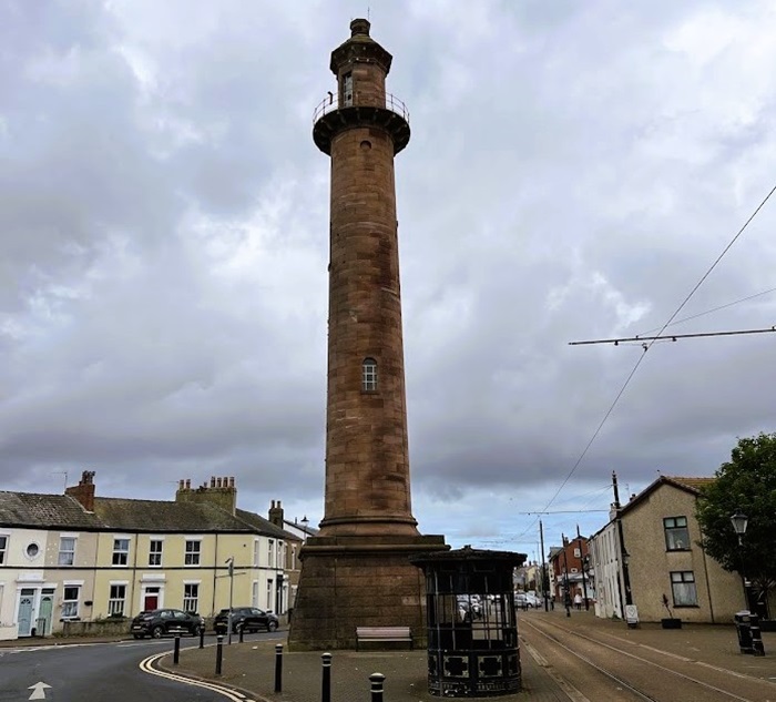
The Pharos Lighthouse is an active lighthouse located in the town of Fleetwood, in Lancashire. Built in 1840, the lighthouse was designed to help guide ships through the Wyre Estuary and into the Fleetwood docks.
The lighthouse is rather unusually located, as it stands in the middle of a residential street in Fleetwood, known as Pharos Street. It is also the only lighthouse in the UK to have a live electric tramway running alongside it, taking the form of the Fleetwood terminal loop of the Blackpool Tramway.
The official name of the lighthouse is simply the Upper Lighthouse, as it was designed in tandem with a much shorter lighthouse (Beach Lighthouse), which stands on Fleetwood’s seafront. It has more commonly been known as the Pharos Lighthouse since its construction, a nod to the Pharos Lighthouse of Alexandria – one of the seven wonders of the ancient world.
The lighthouse was designed by Decimus Burton, an English architect, and Sir Henry Mangles Denham, a Royal Navy Officer. It cost £1,770 and was first lit in December of 1840, at the same time as the Beach Lighthouse. The two stations were designed so that vessels could line up the two lights when entering the Wyre Estuary, ensuring safe passage through the main channel. The estuary is known for its dangerous sandbanks, and the area was treacherous for navigation prior to the existence of the lighthouses.
Both lighthouses were powered by the town’s gas supply, with each possessing a single parabolic reflector behind the burner. They were later converted to run on electricity. Although Pharos Lighthouse was initially painted in cream and red colours, this was stripped during the 1970s to reveal the bare sandstone it is built from.
Pharos Lighthouse has a cylindrical, sandstone tower which is 27 metres (89 feet) tall. The building is Grade II listed and is owned and maintained by the Port of Fleetwood. The light has a range of 12 nautical miles. It remains a popular landmark in Fleetwood, though the tower is not open to the public.
New Brighton Lighthouse, Cheshire
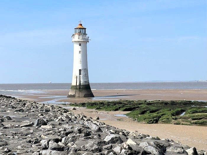
New Brighton Lighthouse (also known as the Perch Rock Lighthouse) is a decommissioned lighthouse located in Liverpool Bay, just off New Brighton. It was first lit in 1830 to guide ships past the Perch Rock.
A light had been shone from the Perch Rock many decades prior to this, with the first record dating from 1683. At this time, a wooden tripod topped with a rudimentary lantern was shone from the rock. This structure was known as a perch, hence why the outcrop has its current name.
As the shipping industry and the port at Liverpool grew during the early 19th century, it became evident that a more substantial light was required on the Perch Rock, as the old one only produced a very limited light and often needed repairs and maintenance. Construction on the current tower began in 1827, using granite rock from Anglesey. It was built using very similar techniques to that of the Eddystone Lighthouse in Cornwall, with each piece of stone interlocking with the next. Work was only possible at low tide, which made it a lengthy process.
After its completion in 1830, the tower was lit using a series of Argand lamps mounted on a rotating array. It displayed two white flashes followed by a red flash each minute, with the red light achieved by way of a panel of red glass mounted on one side. The light revolved on a clockwork mechanism, which also drove the tolling of three large bells under the gallery, which served as a fog signal.
New Brighton Lighthouse shone without fail for almost 150 years, until it was decommissioned in 1973. Modern navigational technology meant the light was no longer required, and the lighting apparatus and foghorn bells were removed.
Despite this, the lighthouse has been very well preserved under private ownership and it was restored and repainted in 2001. At the same time, an LED light was installed in the tower as part of the “River of Light” festival. It was re-lit again most recently in 2016, after the New Brighton Coastal Community Team received a grant. The lighthouse now flashes with the same white and red characteristic as in its prime, though the light is only shone towards land and is not designed to aid the navigation of ships.
New Brighton Lighthouse has a cylindrical granite tower, which tapers from the base and stands 28.5 metres (94 feet) tall. It is a Grade II* listed building and is painted white with a red lantern.
Bidston Lighthouse, Cheshire
The Bidston lighthouse is a decommissioned lighthouse which can be found on Bidston Hill, on the Wirral Peninsula near Liverpool. The current lighthouse was built in 1873 to guide ships through the Horse Channel, which negotiated the dangerous sandbanks of Liverpool Bay.
The first lighthouse on Bidston Hill was constructed in 1771 by Liverpool’s dockmaster, William Hutchinson. Together with the nearby Leasowe Lighthouse, the light at Bidston Hill helped to form a pair of leading lights, which vessels used as navigation beacons. Located two miles from the sea, the Bidston Lighthouse was built further from the body of water it was intended to light than any other lighthouse in the world.
This meant it needed a very proficient lighting apparatus, a requirement which led to Hutchinson developing the first ever parabolic reflector for a lightho
use. Measuring over 12 feet in diameter, this parabolic reflector is thought to have been the largest ever installed in a lighthouse. This gave the light a range of 21 nautical miles, an incredible feat for the time. The light reportedly burned through a gallon of oil every four hours.
The lighthouse was taken over by Mersey Docks and Harbour Board in 1858, and after just over a century of service, the original lighthouse was demolished in 1873 and replaced with the current building.
The new lighthouse was designed by George Fosbery Lyster and also served as an electric telegraph station. Three lighthouse keepers and their families took up residence in the attached keepers’ cottages. The lighthouse was equipped with a first order dioptric lens, which was state-of-the-art at the time and was situated on the fourth floor of the building.
Bidston Lighthouse’s sister lighthouse – Leasowe – was decommissioned in 1908. The Bidston light shone on for a few more years, but did not surpass the years of service of its predecessor, as it was eventually decommissioned in 1913. By this point, the sandbanks in Liverpool Bay had shifted so much that the Horse Channel was almost impossible to navigate, and ships instead used the larger Queen’s Channel, marked by navigation buoys.
The Bidston Lighthouse was restored as part of a Millennium Project in 2000 and is now privately owned, though sometimes open to the public. It has a cylindrical, sandstone tower which is unpainted and stands 21 metres (69 feet) tall. The building is Grade II listed.
Great Orme Lighthouse, Conwy County Borough
Great Orme Lighthouse (also known as the Llandudno Lighthouse) is a decommissioned lighthouse located on the headland of Great Orme, on the north coast of Wales. Established in 1862, it was designed to aid the navigation of ships past the headland and is a rare example of an ‘upside down’ light.
The headland of Great Orme posed a real danger to shipping for many years, with a number of significant wrecks occurring through the years. The Hornby cave, which lies a few hundred metres from where the lighthouse now stands, was named after the wreck of the Hornby – a Liverpool brig – in 1824. The ship hit the cliffs during a storm, resulting in the deaths of 14 people.
This was one of several incidents which highlighted the need for a light, and the Mersey Docks and Harbour Board decided to construct a station on the cliffs at the northern-most point of the headland. Designed by George Fosbery Lyster, the building was certainly not built in a conventional lighthouse style, with its castellated features making it look more like a fort.
The original light, which was placed at the base of the building, took the form of a dioptric optic fuelled by paraffin. In 1873, the lighthouse was taken over by Trinity House and it was upgraded in 1904 to vaporising petroleum mantle burners, which in turn gave way to acetylene mantle lamps in 1923. It was electrified in 1965, giving the light a power of 190,000 candela.
Two lighthouse keepers were on duty at Great Orme while the lighthouse was active, with both living at the station with their families. Each family lived in one half of the building, with a large hallway separating the two living areas to allow privacy.
The lighthouse shone up until 1985, by which point modern navigational aids had rendered it largely redundant. Ownership of the station returned to the Mersey Docks and Harbour Board, who decided to sell the building. The lighting apparatus was removed and was briefly displayed at the Harbour Board’s offices, before being moved to its current display location at the visitor centre at the summit of Great Orme.
Great Orme Lighthouse is now operated as a guest house. The building is a cube-shaped, castellated structure which is made from limestone and is Grade II listed. The building is two storeys tall, with the light sitting at the base.
Trwyn Du Lighthouse, Anglesey
Trwyn Du Lighthouse is an active lighthouse found just off the eastern tip of Anglesey, between Anglesey and Puffin Island. It was built in 1838 to mark the northern entrance to the Menai Strait.
The Isle of Anglesey has seen heavy shipping traffic for several centuries, as it must be rounded by vessels travelling up or down the western seaboard. Ship owners in Liverpool were very keen to have a light established at the eastern tip of Anglesey, known as Black Point or Trwyn Du. The calls became louder after the Rothsay Castle – a paddle steamer – ran aground and broke up near Puffin Island in 1831. 130 people lost their lives.
Despite this, no immediate action was taken, until Trinity House began construction on the current light in 1835. The build took three years to complete, largely due to the lighthouse being situated on sea-washed rocks. It was designed by James Walker, this being the first sea-washed lighthouse he worked on. A number of innovations were made to facilitate construction, including a stepped base to prevent the upsurge of waves.
When it was first lit, the Trwyn Du Lighthouse displayed a red light, whose source came from an Argand lamp within a first order catadioptric optic. It was also given a large 178kg fog bell, to warn ships of danger during poor visibility.
Two lighthouse keepers were employed at the station for many years, but the lighting apparatus was upgraded to an acetylene gas lamp in 1922, which was unwatched, meaning the keepers’ services were no longer required. Trwyn Du therefore became the very first Trinity House lighthouse to be automated.
The lighthouse was modernised greatly in 1996, with the lamp converted to solar power and a unique operating system being developed to sound the fog bell, which rings every 30 seconds. Trinity House began trialling a standard fog horn at the station in 2019 instead of the bell, sparking backlash from locals.
Trwyn Du Lighthouse has a cylindrical, stone tower which stands 29 metres (95 feet) tall. It is painted with black and white horizontal bands and has the words “NO PASSAGE LANDWARD” written on its north and south sides. The light has a range of 12 nautical miles, flashing once every five seconds.
Skerries Lighthouse, Anglesey
The Skerries Lighthouse is an active lighthouse situated on The Skerries – a group of rocky islets off the north-west coast of the Isle of Anglesey. The lighthouse was built in 1717 to guide ships past the rocks.
The first proposal for the establishment of a light at The Skerries was made as early as 1658. However, this was opposed by Trinity House, along with a subsequent petition in 1705. But in 1714, William Trench – who held the lease for The Skerries – was granted a patent from Queen Anne to build a lighthouse and receive dues from ships.
The original light was first lit in November of 1717, but it did not turn out to be as profitable as Trench had hoped, especially as ship owners regularly evaded the payment of dues. By the time of his death in 1725, Trench was heavily in debt. The lease passed to Trench’s son-in-law, and an Act of Parliament was passed to give his family and their heirs sole claim to The Skerries.
The lighthouse was rebuilt in 1759, at the time being lit by a coal-fired brazier on top of the tower. The height of the tower was increased in 1778 and an oil-burning lantern was installed. In 1824, Trinity House attempted to purchase the Skerries Lighthouse from the owners, however they refused, citing the original Act of Parliament.
By this point, the station was substantially profitable, with the owners receiving 1 penny per ton from every commercial vessel entering Liverpool. After a seven year battle, Trinity House eventually succeeded in buying the lighthouse in 1841, at a hefty cost of £444,984. It was the last privately owned lighthouse in the UK to be purchased by the lighthouse authority.
Under its new ownership, the Skerries Lighthouse was restored by the engineer James Walker in 1851, who decreased its diameter, fitted a solid parapet and installed a new cast iron lantern. The lighthouse was electrified in 1927 and automated in 1987.
The Skerries Lighthouse has a cylindrical stone tower, measuring 23 metres (75 feet) high. It is attached to a two-storey lighthouse keepers’ house and the entire building is Grade II* listed, and painted white with a red horizontal band. The first order catadioptric lens houses a light with a range of 20 nautical miles.
South Stack Lighthouse, Anglesey
South Stack Lighthouse is an active lighthouse on the summit of South Stack, a small island off the north-west coast of Anglesey. Established in 1809, it was designed to warn ships of the dangerous rocks around the island.
A petition to construct a lighthouse on South stack was first put to King Charles II in 1665, however this was not granted and it wasn’t until almost 150 years later that the lighthouse appeared. Trinity House decided a light was necessary, with surveyor Daniel Alexander tasked with designing the station. It was first lit in February of 1809, fitted with Argand oil lamps and reflectors.
South Stack is separated from Anglesey by about 30 metres of water. While this is a short distance, the seas are often turbulent and the topography of the islet meant that the only way to reach it during the early days of the lighthouse was being winched across in a wicker basket suspended from a cable. An iron suspension bridge was installed in 1828 to provide an easier means of access.
Despite the presence of the lighthouse and others, a number of vessels were driven ashore around Anglesey during the Royal Charter Storm of 1859. Regarded as the worst storm of the century, many lives were lost around the British coastline, including one of the lighthouse keepers at South Stack, who was fatally struck by a falling rock.
The lighthouse’s lighting apparatus received an upgrade in the mid 1870s, with a new lantern and new machinery installed. An early form of incandescent light was then used at the station from 1909 until 1927, when it was replaced by a more modern incandescent mantle burner.
It was electrified in 1938 and automated in 1983, with the keepers withdrawn and the station monitored remotely by Trinity House. The suspension bridge to the island was also closed around the same time due to safety reasons, however it was replaced by a new aluminium bridge in 1998. This allowed public access to the island, which remains today, and the lighthouse is open seasonally for tours and visits.
South Stack Lighthouse has a cylindrical stone tower which is painted white and stands 28 metres (92 feet) tall. It is a Grade II listed building and the light has a range of 24 nautical miles. There is also a fog signal at the station, which produces a blast every 30 seconds.
Strumble Head Lighthouse, Pembrokeshire
Strumble Head Lighthouse is an active lighthouse located on Ynys Meicel (St Michael’s Island), also known as Strumble Head – a small island situated a few miles west of Fishguard. The lighthouse was built in 1908 to help guide ships travelling between Wales and Ireland.
Despite the lighthouse being a relatively modern one (it is in fact one of the youngest in the UK), a proposal to establish a light on Strumble Head was first made way back in 1825 by Trinity House. This came to nothing however, and it wasn’t until the early 20th century that construction began.
This decision was largely influenced by the loss of at least 60 vessels in the stretch of water between Ireland and Fishguard Harbour in the 19th century. The coastline around Pembrokeshire in particular was known for its dangers, and the Strumble Head Lighthouse provided a greater degree of safety for shipping traffic. It replaced a light vessel which had previously operated in the southern part of Cardigan Bay.
The tower was equipped with a first order catadioptric Fresnel lens, which it retains to this day, sitting in a bath of mercury to reduce friction. Originally, the light was fuelled by paraffin and revolved thanks to a clockwork mechanism which was driven by a large, descending weight installed in the tower. This needed to be re-wound every 12 hours or so by the lighthouse keepers, to ensure it kept running. For many years, Strumble Head Lighthouse also used an explosive fog signal to warn ships of the island during poor visibility.
Access to the island was provided by way of an iron bridge, which was once used to deliver fuel to the station through a siphon which ran within the bridge’s handrail. Despite the bridge’s presence, supplies for the station were often transferred from the mainland via cable. The original bridge was replaced in 1963.
The clockwork system was updated when the lighthouse was fully electrified in 1965, and the old fog signal was replaced with an electric one. The station was automated in 1980.
Strumble Head Lighthouse has a 17 metre (56 feet) high tower, which is painted white and is cylindrical in shape, made of stone. The building is Grade II listed and the light has a range of 26 nautical miles.
Smalls Lighthouse, Pembrokeshire
The Smalls Lighthouse is an active lighthouse located on the largest of a group of wave-washed rocks called The Smalls, 20 miles west of the Marloes Peninsula in Pembrokeshire. Built in 1861, it is notable for being the most remote lighthouse operated by Trinity House, and is famous for the Smalls Lighthouse tragedy.
The first lighthouse on The Smalls appeared in 1776, erected by John Phillips, a merchant and shipowner from Liverpool. It was formed of an octagonal hut, perched on nine wooden pillars. Lit by eight oil lamps, this lighthouse suffered extensive damage during storms in 1777 and Phillips, lacking the funds to repair it, extinguished the light. As a result, Trinity House obtained at Act of Parliament authorising them to repair and maintain the lighthouse in 1778.
In 1801, an incident occurred at the Smalls Lighthouse which changed the future of lighthouse keeping forever. At the time, two keepers – Thomas Howell and Thomas Griffin – were stationed at the lighthouse. The two men did not get along well, a fact which was publicly known.
At some point, Griffin became seriously ill. Howell attempted to get help, but the poor communication links at the time, combined with the station’s remote location and terrible weather, meant that none arrived. Despite Howell’s efforts to help his colleague, Griffin died after a few weeks.
Fearing that he would be accused of murder if he discarded the body in the sea, Howell stored the body in a makeshift coffin when it began to decompose, lashing it to the outside of the lighthouse. As the storms continued, the wind blew the box partially open and the body’s arm fell in view of the window, appearing to wave and beckon to Howell in the gusts, tormenting him day after day.
It is not known for sure how long Howell had to spend alone with the body, but by the time he was rescued he was suffering from severe psychological trauma, and had reportedly gone mad. From this point onward, lighthouses were always staffed with three keepers.
The original Smalls Lighthouse was replaced with a much more substantial structure in 1861, designed by James Walker. This had a helipad installed above the lantern in 1978, and was automated in 1987.
The Smalls Lighthouse is a tapered cylindrical tower, which stands 41 metres (135 feet) high, making it the tallest Welsh lighthouse. It has a first order catadioptric lens, which produces a light with a range of 18 nautical miles.
Whiteford Lighthouse, Vale of Glamorgan
Whiteford Lighthouse is a decommissioned lighthouse located near Whiteford Sands, on the north-west Gower Peninsula. It was built in 1865 to mark the south side of the channel approaching the port of Llanelli. Though not the most attractive lighthouse, it is important as the only wave-swept cast iron lighthouse of significant size left in Britain.
The first structure to light the waters near Whiteford Point was a rudimentary wooden building, which was erected in 1854. This didn’t last very long, and it was replaced by the current lighthouse in 1865. This new lighthouse was designed by John Bowen and constructed by the Llanelli Harbour and Burry Navigation Commissioners.
Due to its location within the estuary, a series of wooden piles had to be driven into glacial moraine to help form the foundations for the tower. Work was undertaken at low tide and the lighthouse was made from cast iron plates, each one bent into place and bolted together.
The tower was fitted with three Argand lamps and reflectors, with each one fixed and facing a different direction. One faced towards the south channel approaching Llanelli, the second faced towards Burry Port and the third faced towards Llanelli itself. A fourth was installed by the Harbour Master in 1876, facing west towards the north channel.
At a similar time, cracks began to develop in some of the iron plates lower down the lighthouse. This was thought to be caused by lateral pressure due to the inner masonry within the tower settling. Work was undertaken by a local blacksmith to make a series of wrought iron straps to attach to the affected plates.
There appears to have been provision for two lighthouse keepers at Whiteford while it was active, though only one was named from 1871 to 1901. Conditions for the keepers were very cramped and they spent two weeks at the station at a time, alternating with two weeks at Llanelli Harbour Lighthouse.
Whiteford Lighthouse was decommissioned by 1933, after which responsibility for it fell to Trinity House. The lighthouse authority decided it was not worth re-lighting, however calls from local boat crews resulted in it being re-illuminated in the 1980s. This was funded by the Harbour Commissioners and the Burry Port Yacht Club. The new light was fully automatic but was eventually removed after the failure of the solar unit powering it. Since then, the tower has been used as a simple day mark.
Whiteford Lighthouse is a cylindrical, slightly tapered cast iron tower, which stands 13.5 metres (44 feet) high. When it was lit, it had a range of 7 nautical miles. The structure is Grade II* listed, due to its importance as an example of cast iron architecture.
Nash Point Lighthouse, Vale of Glamorgan
Nash Point Lighthouse is an active lighthouse situated on the Nash Point headland, in the Vale of Glamorgan. It was built in 1832 to guide ships past the Nash Sands – a dangerous sandbank just off the Point.
Many ships have been stricken on the Nash Sands over the years, with some even said to have been lured to their demise by smugglers operating in the area centuries ago. The trigger for the construction of the lighthouse was the wreck of the Frolic in 1831. The Frolic was a passenger ship which became stuck on the sandbank on its way to Bristol from Haverfordwest, with the loss of around 78 lives.
Trinity House decided to establish two towers on Nash Point immediately afterwards, with the foundations being laid just a few months after the tragedy. The two towers stood about 300 metres apart, both shining lights in order to distinguish the station from other lighthouses in the region. The tower to the west stood 25 metres (82 feet) tall, while the taller eastern tower measured 37 metres (121 feet). One keepers’ dwelling was built at each tower, with two additional cottages being constructed by 1900.
A fog signal station was installed alongside the towers in 1906, using compressed air to provide a regular blast of sound during poor visibility. The light in the lower tower was extinguished in the 1920s, due to red sectors being introduced at the higher tower. These made it easy to identify the lighthouse, rendering the lower tower redundant.
The original light at Nash Point was provided by way of Argand burners, though these were replaced with paraffin burners later on, before the station was eventually electrified in the 1960s.
Despite the presence of the lighthouse, the tanker BP Driver ran aground on the rocks at Nash Point in 1962. The ship was abandoned by the crew, who all survived. The remains of this wreck can still be seen near the lighthouse at low tide.
Nash Point Lighthouse was permanently relieved of its keepers in 1998, making it the last manned lighthouse in Wales. The fog signal has also been relieved of permanent duty, although it is sounded occasionally for visitors. The lighthouse now has a visitor centre and tours of the station can be booked.
Nash Point Lighthouse has a cylindrical stone tower, which reaches 37 metres (121 feet) high. It is painted white and is a Grade II listed building. The light, which still flashes white and red, has a range of 21 nautical miles.
Flat Holm Lighthouse, Vale of Glamorgan
Flat Holm Lighthouse is an active lighthouse found on the island of Flat Holm, where the Bristol Channel meets the Severn Estuary. It was built in 1737 to help guide vessels safely past the island.
Before the lighthouse was established, a basic coal-fired brazier was present on the eastern side of the island. However, this light was very unreliable and the boom in shipping traffic in the region during the early 18th century led to discussions of a proper lighthouse being built. A number of petitions and proposals for a station were made in the early 1730s, though these failed.
Towards the end of 1736, a vessel crashed on a group of rocks very near Flat Holm, resulting in the deaths of 60 soldiers. This tragedy made the need for a lighthouse even more obvious, and a Bristol man named William Crispe – who had made previous proposals – submitted an updated proposal to build a station. This was agreed upon by the Merchant Venturers of Bristol, together with Trinity House.
Crispe began constructing the lighthouse, and it was completed in 1737, with the light first exhibited the following year. The tower suffered damage in 1790 after being struck by lightning during a storm, with the lighthouse keepers making a narrow escape.
Trinity House made an agreement to maintain and improve the lighthouse in 1819 for an annual fee, and work began on improving the station. The height of the tower was increased by 6 metres to allow for the installation of a new lantern, holding an Argand lamp. The new fixed white light was exhibited in 1820, and Trinity House decided to purchase the lighthouse outright two years later.
A number of further improvements were made to Flat Holm in the following decades, including the addition of a clockwork mechanism to rotate the light in 1881. A fog signal station was established near the lighthouse in 1908, utilising compressed air to produce two blasts in quick succession from a pair of horns.
Three lighthouse keepers were stationed at the lighthouse for many years, but an additional keeper was added to the station in 1929. At the same time, the lighthouse was renovated and more accommodation was provided. The keepers looked after the light up until its eventual automation in 1988. It was then modernised and converted to solar power in 1997.
Flat Holm Lighthouse has a cylindrical stone tower, which is painted white and rises 30 metres (98 feet) tall. The station is Grade II listed and the light has a range of 15 nautical miles.
West Usk Lighthouse, Monmouthshire
West Usk Lighthouse is a decommissioned lighthouse located where the River Usk meets the Severn Estuary, just south of the city of Newport in Monmouthshire. The lighthouse was established in 1821 to mark the entrance to a river channel leading to the Newport docks.
West Usk Lighthouse was designed by James Walker, the famous Scottish engineer. It was the very first lighthouse Walker worked on, and he went on to design a further 21 lighthouses, mainly for Trinity House. The lighthouse was built by a pair of local builders and the light was first exhibited in December of 1821.
Originally, the building stood on a small island at one side of the mouth of the River Usk, however a large amount of land reclamation was undertaken in the area during the mid 1850s, mainly for use as farmland. This connected the island to the mainland and a road to the lighthouse was built at the same time.
In 1893, Trinity House built a smaller lighthouse – the East Usk Lighthouse – on the opposite side of the river to the West Usk Lighthouse. For a time, the two lights worked in tandem to mark the entrance to the channel. The East Usk Lighthouse was built to a smaller scale than its compatriot and was originally lit with 12 gas cylinders.
In the following few decades, the need for the light at West Usk diminished and it was eventually decommissioned in 1922. The East Usk Lighthouse remained, and indeed this lighthouse is still active today, owned and maintained by the Newport Harbour Commissioners.
After West Usk Lighthouse was decommissioned, it spent a short time as a private home, before falling into disrepair. It was then used as a lookout post during World War II, with it said to have seen the first action of the war when a German vessel was seen heading towards the Newport docks. Though the ship was boarded, it was so soon after war had been declared that the crew were not even aware it had happened.
The lighthouse was turned back into a private residence after the war, before again falling into disrepair during the late 20th century. At this point, it was taken over and restored, before beginning operation as a guest house. The owners restored the lantern as a replica of the original.
West Usk Lighthouse has a cylindrical tower which is painted white and sits atop an unusual drum-shaped living accommodation. The tower is 17 metres (56 feet) high and the building is Grade II listed.
Lundy North Lighthouse, Devon
Lundy North Lighthouse is an active lighthouse located on Lundy Island in the Bristol Channel, about 19 km off the Devon coastline. Built in 1897, it was designed to guide ships past the northern part of the island.
Lundy has three lighthouses in total, of which two are active. Lundy Old Lighthouse was built by Trinity House in 1819, taking the form of a 29 metre (96 feet) high granite tower. This tower exhibited two lights, provided by Argand lamps, with the first being a fixed light and the second a quick flashing light.
Despite this being an innovation for lighthouses at the time, the revolving light turned so quickly that in effect it also appeared as a fixed light. It is thought that this contributed to the fatal wreck of the ship La Jeune Emma in November 1828. Travelling from Martinique to Cherbourg, the vessel mistook the Lundy Lighthouse for the French Ushant Lighthouse in thick fog and went onto the rocks, resulting in 13 deaths.
With subsequent attempts to improve the light failing, Trinity House set in motion plans to build a pair of new lighthouse on the island. These two lighthouses are the pair currently active on Lundy, each one located at one end of the island. The lighthouses were designed by engineer Sir Thomas Matthews, with Lundy North Lighthouse built slightly larger than its sister light.
The North Lighthouse was originally lit with a five-wick oil burner, before this was replaced with a petroleum vapour burner in the early 20th century. Its first-order revolving lens was the very first in a British lighthouse to sit in a bath of mercury, to reduce friction. The station was also equipped with a fog siren, housed in an engine room on the north side of the lighthouse. This siren was improved upon several times in the coming decades, before being decommissioned in 1988.
The lighthouse was converted to electrical operation in 1971 and the old lens was replaced with a fourth-order dioptric lens, mounted on a gear-less pedestal. The lighthouse keepers were withdrawn in 1976 and the station was fully automated in 1985. It was further modernised in 1991, when it was converted to solar power.
Lundy North Lighthouse has a cylindrical, brick tower which is painted white and measures 17 metres (56 feet) high. The building is Grade II listed and the light has a range of 17 nautical miles.
Hartland Point Lighthouse, Devon
Hartland Point Lighthouse is an active lighthouse located on Hartland Point, on the north-west tip of Devon. It was built in 1874 to aid the navigation of ships approaching the Bristol Channel.
The lighthouse was designed by Sir James Douglass, who at the time was engineer-in-chief for Trinity House. Construction began in 1873 and the light was exhibited for the first time in June of the following year. The original light was a first-order rotating catadioptric array, which flashed alternatively with red and white colours. This impressive light had a range of 25 nautical miles.
As it was built on a rock situated right at the tip of the point, the lighthouse was in a precarious position, with the action of the sea threatening to undermine the station. To counter this, sections of rock were broken off from the cliff behind the light and assembled on the beach below, to form a barrier to the waves. This wasn’t entirely effective, as the rocks were repeatedly washed away during storms. Eventually, a permanent, 6-metre high sea wall was built to hold back the sea.
Accommodation for four lighthouse keepers and their families was provided in dwellings attached to the lighthouse. The station was also equipped with a reed fog signal in its early years, which was later replaced with a two-tone fog siren, before a new reed horn was installed in 1911.
The light was electrified in 1927, with the original optic replaced with a new third-order catadioptric lens, which had a slightly lower range than its predecessor. Electricity at this time was provided by way of a generator, but the station was connected to the mains in 1959. A new electric fog signal was installed a few years later.
Hartland Point Lighthouse was eventually automated in 1984. With the keepers’ dwellings no longer required, and the access road to the lighthouse becoming increasingly dangerous due to rockfalls, Trinity House decided to demolish the dwellings and replace them with a helipad.
The foghorn was decommissioned in 2010, with Trinity House also proposing the light be decommissioned at the same time. This proposal was retracted due to a number of protests, and it was decided in 2012 that a smaller, more economical LED light could be installed in front of the lighthouse, with the main light being switched off.
Hartland Point Lighthouse has a cylindrical, white tower which stands 18 metres (59 feet) tall. The building is Grade II listed and the current external light has a reduced range of 8 nautical miles.
Trevose Head Lighthouse, Cornwall
Trevose Head Lighthouse is an active lighthouse situated on the Trevose Headland on the north coast of Cornwall, a few miles west of Padstow. It was established in 1847 to guide vessels to and from the Bristol Channel.
Trinity House first discussed the construction of a light on this part of the Cornish coastline in 1809, as at the time the only lights assisting the navigation of ships to and from the Bristol Channel were the Longships Lighthouse to the south and the Lundy Old Lighthouse further north. Construction was again discussed in 1813 and 1832, but it wasn’t until 1845 that designs for the lighthouse were submitted and approved.
Soon after completion of the main tower, there were concerns that the light could be mistaken by ships, and so a second, smaller light was built about 50 feet in front of the main tower. Both towers were designed by James Walker, with a covered passage between the two providing access for the lighthouse keepers. Both towers were equipped with first-order fixed optics, with the lights provided by oil lamps. They were first exhibited in December of 1847.
James Douglass, Trinity House engineer-in-chief, changed the high light from fixed to occulting in 1882. At the same time, the lower light at the station was discontinued and it is no longer present today.
A number of improvements were made at Trevose Head from 1911 onwards. The keepers’ dwellings were modified extensively, before work began to install a fog signal at the station. This took the form of an unusually large trumpet, measuring 36 feet long, which was designed by Lord Rayleigh.
A first order catadioptric optic was installed in the tower in 1920, with a paraffin vapour burner replacing the old oil lamp. This was a great improvement to the light and it was given a red filter so that the light would flash red. The optic was rotated by a clockwork mechanism powered by descending weights.
The original fog trumpet was replaced by a series of air horns in 1963, with the light electrified in 1974. Trevose Head Lighthouse was automated in 1995 and the red filter was removed so that the light would exhibit white. The fog signal was decommissioned in 2012 and the original keepers’ cottages are now used as holiday accommodation.
Trevose Head Lighthouse has a 27 metre (89 foot) tall cylindrical, masonry tower. It is painted white and the building is Grade II listed. The light has a range of 21 nautical miles.
Godrevy Lighthouse, Cornwall
Godrevy Lighthouse is an active lighthouse located on Godrevy Island, at the north end of St. Ives Bay in Cornwall. Built in 1859, it was designed to mark a treacherous area of reef known as the Stones.
The Stones were well-known for the hazards they posed to ships, and an increase in shipping traffic along the north coast of Cornwall during the 19th century led to a large number of wrecks on the reef, of ships ferrying passengers and travelling for trade. Plundering of the stricken ships was also a common problem in the area.
While calls for a lighthouse were made, no plans were put in place to build one until after 30 November of 1854. On this date, the cargo steamer SS Nile crashed onto the Stones during a storm, with the loss of all onboard, numbering around 40. This prompted fresh calls for a lighthouse, with Trinity House agreeing to construction in 1856 and James Walker contracted to design it.
The light was first exhibited in March of 1859, coming from an oil lamp set within a first-order catadioptric lens. This revolving light flashed white every 10 seconds, though there was also a fixed red light positioned just below it. Two keepers were stationed at Godrevy at a time, working two months on and two months off. Supplies were ferried regularly to the lighthouse by boat from St. Ives.
Originally, the lighthouse was equipped with a fog bell for when visibility was poor. This was removed in 1934, when a number of changes were made at the station. A new second-order fixed catadioptric lens was installed with an acetylene burner, with the new light incorporating a red sector, meaning the secondary red light could be removed.
The lighthouse keepers were withdrawn in 1939 and the light was automated, with the redundant keepers’ cottages being demolished. In 1995, Godrevy Lighthouse was converted to solar powered operation as part of efforts to modernise the station, though Trinity House decided to discontinue the tower in 2012.
The light in the tower was replaced with an LED one mounted on a steel platform adjacent to the station. Both the light and tower are still maintained by Trinity House, with the tower functioning as a daymark.
Godrevy Lighthouse has an octagonal, white tower and stands 26 metres (85 feet) high. The building is Grade II listed and the now external light has a range of 8 nautical miles.
Longships Lighthouse, Cornwall
The Longships Lighthouse is an active lighthouse found on Carn Bras – the largest of the Longships Islets situated off the coast of Land’s End in Cornwall. The lighthouse was established in 1875, to replace a smaller tower built to warn ships of the rocks.
The first tower was built in 1795, with the rocks prior to this time posing a constant threat to shipping. Trinity House provided a lease to Lieutenant Henry Smith to build and maintain the lighthouse, which was designed by Samuel Wyatt. Smith was soon deemed to be “incapable” of maintaining the light, and Trinity House took it over shortly after it was lit.
The lighthouse was formed of a three storey tower and the lantern stood about 24 metres high. Even at this height, the light was engulfed by the might of storm-driven waves, and it was often obscured from view when conditions were bad. Therefore, Trinity House decided to build a replacement lighthouse – the current one – in 1869.
This lighthouse was far taller and cost over £43,000 to build, with construction using many of the same techniques used for the nearby Wolf Rock Lighthouse. The tower displayed a fixed white light with two red sectors, each designed to warn ships of hazardous rocks to the north-east and south-east of the station.
Soon after, the light was changed to an occulting light and the fog signal, which was initially provided by a bell, was updated to an explosive signal. The bell was retained to be used as a backup for a time, but was eventually removed in 1897. Despite the improvements, a steam cargo ship called the SS Blue Jacket crashed directly onto Carn Bras rock the following year, almost hitting the lighthouse in the process.
The Longships Lighthouse was electrified in 1967, with the light’s range increased to 19 nautical miles. In 1974 a helipad was built above the lantern, providing much easier access for the delivery of supplies and the relief of lighthouse keepers, which was often a difficult task when done by boat. The lighthouse was automated in 1988 and converted to solar power in 2005.
The Longships Lighthouse has a cylindrical, slightly tapered tower which is made of unpainted granite. It stands 35 metres (115 feet) tall. The fog horn, which is also now electric, remains active and the light has a range of 15 nautical miles.
Bishop Rock Lighthouse, Cornwall
Bishop Rock Lighthouse is an active lighthouse found on the Bishop Rock, a skerry 4 miles west of the Isles of Scilly and 28 miles south-west of the Cornish mainland. It was constructed in 1858 to warn ships of the rock and is notable as the joint-tallest lighthouse in England (tied with Eddystone Lighthouse).
The Isles of Scilly have long posed a danger to shipping, with Bishop Rock a particular hazard as it lies at the most westerly edge of the islands. Many wrecks have been recorded on the islands through the years, with the most notable being the Scilly naval disaster of 1707. A fleet of four Royal Navy warships were wrecked on the islands during a severe storm, with the loss of over 1,400 lives, marking one of the worst maritime disasters in British naval history.
The need for more adequate lighting around the islands was clear, and though early proposals were made it wasn’t until Trinity House surveyed Bishop Rock in 1843 that plans to build a lighthouse were put in place. James Walker was in charge of designing the station, initially deciding against a solid tower due to the small size of the rock and the force of the elements it was regularly exposed to.
Instead, he built a screw-pile lighthouse which stood upon iron legs driven into the granite rock. The building was almost complete by the end of 1849, until a huge storm washed the entire structure away. Walker went back to the drawing board and returned to the idea of a solid tower. This was completed, at great difficulty, over a seven year period and the light was first exhibited in September of 1858. The lighthouse was lit by an oil lamp within a first-order catadioptric lens.
In the years that followed, the lighthouse was subject to the full force of Atlantic storms, which proved so powerful that the tower would physically shake, sometimes knocking items off shelves and causing damage to the optical equipment. A survey by Sir James Douglass in 1881 found extensive weakness in the structure, and great efforts were undertaken to strengthen the tower.
The optics underwent a number of improvements in the following decades, until the station was electrified in 1973. A helipad was installed above the lantern a few years later and the lighthouse was fully automated in 1992.
Bishop Rock Lighthouse has a cylindrical, tapered tower which measures 49 metres (161 feet) tall. The building is Grade II listed and the light has a range of 20 nautical miles.
Round Island Lighthouse, Cornwall
Round Island Lighthouse is an active lighthouse located on the most northerly islet in the Scilly Isles, in Cornwall. It was built in 1887 to improve the safety of shipping around this region of the islands.
Prior to construction of the Round Island light, the Scilly Isles were lighted by the Bishop Rock Lighthouse, which aided western approaches to the islands, and the St. Agnes Lighthouse, which aided southern approaches. The seas at the north end of the islands remained dangerous however, especially during foggy conditions.
As a solution to this, Trinity House decided on the small, granitic Round Island as the best site for a new lighthouse. The top of the island forms a platform, which falls away to rather steep cliffs. This made the construction process tricky, with it almost impossible to land supplies on the island by boat. A set of steps were cut into the rock to allow access from the water, and goods were hoisted onto the island using a combination of ropes and winches.
The lighthouse was designed by William Douglass, with an enormous hyperradial optic weighing about 8 tonnes installed at the top of the tower. A similar one had been installed at Bishop Rock the previous year, and so the light from Round Island was set to produce a red flash every 30 seconds, distinguishing it from the white flashes of the Bishop Rock station. The original light source was a ten-wick burner.
The lighthouse was equipped with a fog signal in 1912, with a pair of Rayleigh Trumpets being installed on a small building alongside the tower. The station was also host to Britain’s first wireless beacon for navigation, designed by the company founded by inventor Guglielmo Marconi.
The light was electrified in 1966, at which point the optic was replaced with apparatus housing a series of sealed beam lamps. The old optic was broken up on site, deemed to be too difficult to preserve.
A helipad was built near the tower a few years later, before the optic was again replaced in 1987, when the station was automated. The colour of the light was then changed from red to white, flashing once every ten seconds.
Round Island Lighthouse has a cylindrical, granite tower which is Grade II listed and stands 19 metres (62 feet) tall. The light has a range of 18 nautical miles and the station retains a fog signal, which sounds four blasts every sixty seconds.
Tater Du Lighthouse, Cornwall
Tater Du Lighthouse is an active lighthouse located on the south coast of the Land’s End peninsula, between Porthcurno and Mousehole. It was built in 1965 to mark the headland it sits upon, and is Cornwall’s newest lighthouse.
The construction of the Tater Du light was possibly one that was overdue, with this stretch of the Cornish coastline proving to be a dangerous one for ships. It was sometimes known as ‘the fishing boat graveyard’ in the past, due to the loss of many local boats.
Two tragedies stand out in particular. 18 lives were lost in 1868 when the Garonne – an iron steamship built in Hull – hit one of the Bucks Rocks just offshore from where the Tater Du Lighthouse now stands. Then in 1963, the Juan Ferrer hit the headlines when it was wrecked on Boscawen Point, near Tater Du. 11 were killed, prompting the Newlyn and Mousehole Fishermen’s Association to request that Trinity House build a lighthouse to ensure no similar tragedies could happen again.
This, combined with the media coverage, encouraged Trinity House to act. Work began on the lighthouse in 1964, with design work carried out by Michael H. Crisp. The lighthouse was the very first in the UK to be built with the intention that it be fully automatic, and the light was first exhibited in July of 1965.
The high-tech equipment originally installed at the station included 72 fog signal speakers built into the lighthouse tower. These were later replaced by a short-range electric emitter, which produced two blasts every 30 seconds. The lighthouse was modernised between 1996 and 1997, and its fourth-order rotating light is powered by batteries charged from the mains.
The main light flashes white every 15 seconds, while an additional fixed red light shines over the nearby Runnelstone Rocks from a window lower down the tower. The fog signal was decommissioned in 2012.
Tater Du Lighthouse has a cylindrical, concrete tower which is painted white and stands 15 metres (49 feet) high. The light has a range of 20 nautical miles. The surrounding area is a Site of Special Scientific Interest due to its unusual geological features, while the Bucks Rocks are popular spots for diving.
Wolf Rock Lighthouse, Cornwall
Wolf Rock Lighthouse is an active lighthouse situated on the Wolf Rock – a tiny rock located about 8 miles south-west of Land’s End in Cornwall. Established in 1869 to warn ships of the rock, it is notable for being the first lighthouse in the world to be fitted with a helipad.
A patent to build a lighthouse on Wolf Rock was first awarded to Lt. Henry Smith in 1791. However, Smith quickly found the task to be incredibly difficult and opted instead to erect an unlit daymark on the rock, formed of a 6 metre-high iron mast. This was soon washed away – a fate suffered by several more beacons until 1848, when Trinity House engineer James Walker build a small, cone-shaped structure, which remains to this day.
In 1861, work began on a lighthouse, also to the design of James Walker. The Wolf Rock was an incredibly difficult site to build a tower on, and Walker’s designs stuck closely to the already-established lighthouses at Bishop Rock and Eddystone. After three years of work, just 37 stones were laid, with conditions challenging to say the least. In the meantime, Walker sadly died at the age of 81, and he was replaced as engineer at Wolf Rock by William Douglass.
Construction continued and the lighthouse was eventually completed in 1869, after 8 years of work. A large first-order lens was installed, flashing red and white alternatively to distinguish the station from the St. Agnes Lighthouse. The light was rotated by clockwork mechanism, which was also used to sound a fog bell.
A more powerful oil-burner was installed in the tower when it was modernised in 1904, with a reed fog signal replacing the bell. The light was further improved in 1955 when the station was electrified, with a tungsten filament lamp installed within a new fourth-order catadioptric optic. The new light had a range of 16 nautical miles.
History was made in 1972 when the Wolf Rock Lighthouse became the first in the world to be fitted with a helipad, greatly improving the ease with which keepers could be transported to and from the station. It wasn’t long before their services were no longer required however, with the lighthouse automated in 1988.
Wolf Rock Lighthouse has a tapered, cylindrical tower which is made of granite. It is unpainted and measures 41 metres (135 feet) in height. The light is now solar-powered and it retains a range of 16 nautical miles.
Lizard Lighthouse, Cornwall
The Lizard Lighthouse is an active lighthouse located at the tip of the lizard peninsula, the most southerly part of the British mainland. The lighthouse was built in 1752 to guide ships past the point.
With the waters off the Lizard known for their hazards, a beacon was first erected on Lizard Point in 1619 by Sir John Killigrew. This early light proved valuable to passing ships, but difficulties in encouraging ship owners to pay dues meant that the beacon was woefully underfunded, and Killigrew was almost bankrupted. The light was extinguished and the tower demolished in 1630.
More than a hundred years later, Trinity House supported the merchant Thomas Fonnereau in establishing a new lighthouse in 1752. The station was formed of two towers, each one topped by a coal-fired brazier. Trinity House took over the lighthouse in 1771, opting to replace the braziers with oil lamps in 1811 as part of a thorough improvement of the site.
In the following years, new keepers’ cottages were added and an engine room was constructed, bringing electricity to the lighthouse. Three caloric engines were used to power two arc lamps in the towers, as well as a fog signal. A pair of third-order fixed catadioptric optics were installed to house the lights in 1874, though the one in the eastern tower was replaced with a first-order rotating optic in 1903. The power and range of this new light meant that the one in the western tower could be removed.
A pair of new fog sirens were fitted to the roof of the engine house shortly afterwards, and an electric filament lamp was installed at the Lizard Lighthouse in 1926, providing a greater degree of automation at the site and facilitating a reduction in personnel, from five to three.
The lighthouse was then connected to mains electricity in 1950, though a series of diesel engines were used to run compressors for the fog signal. A fire broke out in the exhaust pits of the engines in 1954, however the keepers were successful in extinguishing it before significant damage occurred. The station was eventually automated in 1998.
The Lizard Lighthouse has two octagonal towers, with the eastern tower housing the light and standing 19 metres (62 feet) tall. The building is Grade II listed and the light has a range of 26 nautical miles. Part of the building is home to the Lizard Lighthouse Heritage Centre, which is open to visitors.
Eddystone Lighthouse, Cornwall
Eddystone Lighthouse is an active lighthouse located on the Eddystone Rocks, 13 miles south-west of Plymouth. It was built in 1882 to warn ships of the dangers posed by the rocks, and is notable for being the joint-tallest lighthouse in England (tied with Bishop Rock Lighthouse).
The current lighthouse is the last in a line of four structures to light the Eddystone Rocks – a large reef which is often submerged at high spring tides and was the scourge of many sailors in the years before a lighthouse appeared. The first tower was a wooden structure built in 1698 by Henry Winstanley, an engineer and merchant who had previously lost two ships on the Eddystone Rocks.
At the time, France was at war with England, and Winstanley was captured by a French privateer during the construction, before he was ordered to be released by French King Louis XIV, who recognised the importance of the work. Winstanley was later killed along with five other men working on the lighthouse during the Great Storm of 1703, which completely destroyed the tower.
After this disaster, Captain John Lovett acquired a lease of the rock and employed John Rudyerd to build a new cone-shaped tower. This proved to be more steadfast than its predecessor, standing for 47 years after its illumination in 1709. The roof of the lantern caught fire in 1755, possibly born from a spark from one of the 24 candles. The tower burned for several days, before crumbling into the sea.
No time was lost in constructing the third lighthouse, built by civil engineer John Smeaton in 1759. Smeaton employed his knowledge and talent to build an impressive tower, through the application of several engineering breakthroughs such as quick-drying cement and the combination of dovetail joints and marble dowels. Smeaton’s Tower, as it became known, stood for over 120 years, before erosion of the rock it stood upon meant that a new tower was required.
Smeaton’s Tower was dismantled in 1882 and replaced with the current lighthouse in the same year, built by James Douglass. Douglass used Robert Stevenson’s developments of Smeaton’s techniques to build the tower, which was topped with a rotating, first-order optic. The lamps were later replaced with incandescent oil burners, before the tower was electrified in 1959.
A helipad was established above the lantern in 1980, and two years later the Eddystone Lighthouse became the first offshore Trinity House light to be automated.
Eddystone Lighthouse has a tapered, cylindrical tower which is made of granite and stands 49 metres (161 feet) high. The light flashes twice every 10 seconds and has a range of 17 nautical miles.
Plymouth Breakwater Lighthouse, Devon
Plymouth Breakwater Lighthouse is an active lighthouse found on the western edge of Plymouth Breakwater – a stone barrier which protects the anchorages surrounding Plymouth. The lighthouse was built in 1843 to mark the breakwater.
Plymouth Breakwater is a 5 kilometre-long structure that was designed by John Rennie and completed in 1841. It is a colossal feat of engineering, said to have required 4.5 million tons of stone to build, at an equally sizeable cost of £1.5 million (over £87 million in today’s terms).
In addition to designing the breakwater, John Rennie also drew up designs for the lighthouse, though he sadly died before the breakwater was completed. The lighthouse was therefore designed by Walker & Burgess, with the light first illuminated in June of 1844. It was provided with a second-order catadioptric lens, which displayed a fixed red light with a white sector. These colours were later reversed, and a second light was installed further down the tower to mark two hazards – the Draystone Reef and a shoal known as the Knap.
There were original plans to establish a second lighthouse on the eastern edge of the breakwater, however it was decided that a 5.2 metre beacon would be sufficient. This was topped with a round cage, to provide refuge for up to six sailors in the event of a shipwreck.
A 7 cwt fog bell was installed at the lighthouse in 1867, before it was replaced with a much larger bell in 1879. This larger bell had previously been in use at the Start Point Lighthouse, before it had been replaced with a fog siren. Plymouth Breakwater Lighthouse was looked after by several keepers for many years, but its conversion to acetylene gas in 1920 meant that it could be automated.
In the same year, a French sailing vessel by the name of Yvonne ran aground on the breakwater during a storm, after its captain had attempted to make for Plymouth to seek shelter. Luckily, the crew were rescued from the breakwater by the Plymouth lifeboat.
Trinity House, who had previously been responsible for monitoring the lighthouse, passed this responsibility on to the Ministry of Defence in 1993. The fog bell was replaced with an electric foghorn the following year.
Plymouth Breakwater Lighthouse has a cylindrical stone tower, which is painted white and stands at a height of 23 metres (75 feet). The main light flashes once every ten seconds and has a range of 12 nautical miles.
Smeaton’s Tower, Devon
Smeaton’s Tower is a memorial lighthouse which stands on Plymouth Hoe, in the city of Plymouth. The lighthouse was originally built on the Eddystone Rocks and was in use from 1759 until 1877, before it was dismantled and re-built as a memorial to its designer, John Smeaton.
Smeaton’s Tower was the third lighthouse to be erected on the Eddystone Rocks, and it remains the most notable example to this day, as it represented a huge step forward in lighthouse engineering. Smeaton – who was an aspiring civil engineer and maker of mathematical instruments – was recommended for the job of designing the lighthouse by the Royal Society. He proposed that the tower should be modelled on the shape of an English oak tree and built of stone.
Smeaton assembled a team of workers, largely made up of Cornish tin miners. At the time, press ganging (where men were kidnapped and forced into the navy) was a common problem for workers, so Trinity House arranged for the workers to receive a medal from the Admiralty at Plymouth proving that they were working on the light.
The enduring significance of Smeaton’s Tower largely stems from the breakthroughs Smeaton developed in order to build it. He developed the use of hydraulic lime – a type of quick-drying cement – which allowed cement to set underwater. This proved valuable in establishing the tower on the partially submerged rocks. In addition, Smeaton pioneered a groundbreaking method of fusing individual stones to each other through the use of dovetail joints and marble dowels.
Smeaton’s Tower was first lit in October of 1759, with the light provided by 24 candles. It shone for 123 years, before the erosion of the underlying rock led to the tower becoming unstable. Plymouth Council proposed that the light be dismantled and re-built on Plymouth Hoe, in place of a daymark. Trinity House agreed and around two thirds of the original tower was moved to its current site, placed on a replica base. The original base can still be seen at the Eddystone Rocks.
Smeaton’s Tower was opened to the public in 1884, and has since been preserved as a ‘monument to Smeaton’s genius’. Visitors can climb the 93 steps to the top of the tower, to enjoy spectacular views of the surrounding area.
Smeaton’s Tower is a cylindrical, slightly tapered stone structure which stands 22 metres (72 feet) high. It is a Grade I listed building and is painted with red and white horizontal bands, so it can be used as a daymark.
Start Point Lighthouse, Devon
Start Point Lighthouse is an active lighthouse located on the Start Point promontory, near Dartmouth in Devon. It was built in 1836 to mark the peninsula for passing ships.
The dramatic stretch of coastline from Start Point to Dartmouth is a graveyard for shipping, littered with all manner of vessels, spanning the centuries of maritime history in Britain. As one of the most exposed promontories in the region, Start Point is a particular hazard to shipping and it was this fact that resulted in the establishment of a lighthouse by Trinity House.
The station was designed by James Walker, with the tower crowned with a revolving dioptric optic. This was the first time Trinity House had installed such an optic in one of their lighthouses. The station was also fitted with an additional, fixed light, which shone towards the Skerries Bank offshore.
Despite the light proving to be hugely beneficial to ships during normal weather conditions, it was found to be inadequate during foggy weather. As a result, a fog bell was installed at the site in 1862, driven by a descending weight housed in a small building on the nearby cliff edge. This was replaced by a fog siren in 1877, with the bell transferred to the Plymouth Breakwater Lighthouse.
The accommodation at the station was expanded in 1871 and a new lantern was installed at the top of the tower two years later, designed by James Douglass. A more powerful optic was installed within, increasing the range of the main light. The subsidiary light was also changed to use light directed via prisms from the main light, rather than having its own light instead. This light remains, but now shines red instead of its original white.
Erosion of the cliffs caused the fog signal building to collapse in 1989. Much of the remaining site was levelled in response to this, while retaining walls were built. A new electric fog signal was installed in the lighthouse gallery. The lighthouse was automated in 1993 and modernised in 2019, with LED lamps installed.
Start Point Lighthouse has a cylindrical, brick tower which is painted white and stands 28 metres (92 feet) tall. The main light has a range of 18 nautical miles, while the subsidiary light has a range of 9 nautical miles. The building is Grade II listed and now has a visitor centre to allow public access and tours.
Berry Head Lighthouse, Devon
Berry Head Lighthouse is an active lighthouse found on Berry Head, near Brixham in Devon. Established in 1906 to complete a chain of lighthouses along the south coast, it is notable as reportedly being the shortest lighthouse in the UK.
Standing just 5 metres tall, the reason for its diminutive stature is its location, as the cliffs at Berry Head rise to around 58 metres above sea level, providing the light with a great vantage point. When it was first lit in 1906, the optic was turned by the action of a weight which descended down a 45 metre shaft below the lighthouse. It is also sometimes referred to as the ‘deepest’ lighthouse in the UK as a result. This mechanism was later made redundant, with an electric motor being used to revolve the light instead.
Despite being staffed in its early years, the lighthouse was automated in 1921 and converted to run on acetylene at the same time. Housed within a third-order dioptric optic at first, the light had a range of 19 nautical miles and produced a double flash every 15 seconds. Although not fitted with a fog signal, a signal station was present nearby.
Berry Head Lighthouse was modernised in 1994, when it was connected to mains electricity. More recently, it was upgraded in 2019 as part of Trinity House’s ‘simple lighthouse’ scheme. The third-order optic was removed and replaced with a system using self-contained LED lanterns, both for the main light and for a standby light. Not only dis this make the light more energy efficient, it also reduced the need for frequent maintenance visits and will extend the life of the station for at least 20 years.
Berry Head Lighthouse does not technically have a tower, with the lantern room simply attached to equipment buildings. It is painted white and stands 5 metres (16 feet) tall. Since being converted to LED operation, the light has seen a slight range reduction, from 19 to 18 nautical miles. It flashes with the same characteristic of two every 15 seconds. Though the station is not open to the public, Berry Head is popular with visitors and is designated as an area of outstanding natural beauty.
Portland Bill Lighthouse, Dorset
Portland Bill Lighthouse is an active lighthouse located on the Isle of Portland, in Dorset. It was built in 1906 to help guide ships in and out of Weymouth and Portland, as well as acting as a way mark for navigation through the English Channel.
The waters surrounding Portland Bill can be treacherous for ships, as the sea is funnelled through a gap between the Bill and a sandbank just offshore, known as the Shambles. This creates the Portland Race, characterised by very strong currents. Various ships have met their demise on the promontory or on the iconic Chesil Beach over the years.
Aiming to put an end to this, the people of Weymouth petitioned Trinity House to build a lighthouse at Portland Bill. This was initially disregarded, but in 1716 Trinity House eventually obtained a patent from King George I and issued a lease to a private company to build and maintain two lights. These both used coal fires and acted as leading lights, though they were poorly managed and sometimes not lit at all.
When the lease came to an end, the two lights returned to Trinity House and efforts were made to improve them. Argand lamps were installed in 1788, with the Portland Lighthouse becoming the first in England to use them. The two lighthouses shone for over 80 more years, before the decision was made to re-build them in 1869. The new lighthouses did not guide passing ships for long however, as they were replaced with the current Portland Bill Lighthouse in 1906. The two old lighthouses remain on the island, but are no longer lit.
Portland Bill Lighthouse initially used a paraffin lamp, placed within a first-order revolving optic. A red sector was added below the main light, indicating the Shambles sandbank. A diaphone fog signal was installed at the station in 1940, before the lighthouse was electrified. The station was automated in 1996, with the fog signal decommissioned at the same time, before it was restored for the purposes of being sounded for visitors. A new LED lantern was installed in 2019 as part of modernisation work.
Portland Bill Lighthouse has a cylindrical, sandstone tower which is painted white with a red horizontal band. The tower stands 41 metres (135 feet) high and the building is Grade II listed. The light has a range of 18 nautical miles, and is very unusual in that its character gradually changes from one flash to four flashes as it rotates, due to the arrangement of the panels.
Needles Lighthouse, Hampshire
The Needles Lighthouse is an active lighthouse situated at the end of the Needles – a row of three chalk stacks on the Isle of Wight in Hampshire. Completed in 1859, the lighthouse was designed to guide ships safely into the Solent.
It was not the first light situated at the Needles however, as merchants and shipowners came together to petition Trinity House to build a lighthouse there in 1781. Construction on this tower began four years later, with it positioned on the cliffs above the Needles. Designed by 18th century architect Richard Jupp, the tower was lit with 13 Argand lamps and initially shone white, before being changed to red.
Unfortunately, as the tower was erected on cliffs about 144 metres above sea level, it was often obscured by fog and was therefore of limited use for navigation. For this reason, Trinity House decided to build a new lighthouse in 1859, this time located on the Needles themselves.
Prior to construction, a large section of rock on the outer stack was cut away to provide a level base, while tunnels were excavated into the rock to provide storage rooms. The lighthouse itself was designed by James Walker and built at a cost of £20,000. It was first lit with an oil burner and displayed a fixed red light with a white sector indicating a clear approach south of nearby Durlestone Head. Additional white and green sectors were later added to mark different approaches and channels.
Though at first unpainted, the tower was given a horizontal black band in 1886 to make it more visible to mariners. It was then upgraded to use an incandescent paraffin vapour burner in the early 20th century, but was badly damaged during World War II when a German aircraft opened fire on it. After being repaired, a new second-order catadioptric optic was installed, housing an electric light.
A helipad was built on top of the lantern in 1987, making it easier to relieve keepers of their duties and deliver supplies. The lighthouse was staffed by three keepers for many years, though they left for the last time in 1994, making the Needles Lighthouse one of the last rock stations to be manned in the UK. The station was also provided with mains power around the same time, by way of a submarine cable.
The Needles Lighthouse has a cylindrical tower, which is painted white with two horizontal red bands. It stands 31 metres (102 feet) high and the light has a range of 17 nautical miles.
St. Catherine’s Lighthouse, Hampshire
St. Catherine’s Lighthouse is an active lighthouse found on St. Catherine’s Point, at the southern tip of the Isle of Wight. The lighthouse was established in 1838 to guide ships both through the English Channel and towards the Solent.
The first structure erected as a lighthouse on St. Catherine’s Point appeared way back in 1323, built after a ship ran aground on nearby rocks. This octagonal stone structure survives to this day, known locally as the ‘Pepperpot’. It is the only surviving medieval lighthouse in Britain. Construction of a new lighthouse began in 1785, though this one was never completed due to the hill often being shrouded in fog.
Trinity House then began work on a third structure – the present lighthouse – in 1838. This decision was mainly sparked by the wreck of the Clarendon in October of 1836. Carrying exotic cargo from the Caribbean, the Clarendon got into difficulty in gale-force winds, crashing onto the rocks at the base of Blackgang Chine. At least 23 lives were lost.
The new lighthouse was built 40 metres high (130 feet) and lit with an oil lamp housed within a first-order dioptric lens. However, it was found to suffer from the same problem which inhibited the construction of the second lighthouse, with the light often obscured by fog. To fix this, Trinity House removed a section of the tower, reducing its height by 13 metres. A Daboll trumpet foghorn was installed at a similar time, located in a building near the cliff edge.
St. Catherine’s Lighthouse became one of the first lighthouses in the world to be electrified, when arc lamps were installed in 1888, powered by compound steam engines. Extra accommodation was provided to allow for the increase in staff needed to run the station.
The fog signal building was found to be developing significant cracks in 1932, as erosion and cliff movement took its toll. The building was moved and attached to the lighthouse tower to ensure its survival, while a more powerful siren was installed. Tragedy then struck during World War II, when a German bombing raid in June 1943 destroyed the engine house, killing all three keepers, who had been sheltering in the building.
Until recently, the lighthouse possessed a second-order Fresnel lens, producing a light with a range of 25 nautical miles. However, this was removed in 2021, with plans to replace it with an LED light with a reduced range.
St. Catherine’s Lighthouse has a hexagonal stone tower, which is painted white and stands 27 metres (89 feet) high. The building is Grade II listed and the new LED light has a range of 18 nautical miles.
Shoreham Lighthouse, West Sussex
Shoreham Lighthouse is an active lighthouse located at the entrance to the harbour in Shoreham, a few miles west of Brighton, in West Sussex. It was built in 1842 to guide ships into the harbour.
In the early 19th century, the Sussex towns of Brighton and Worthing saw significant growth, with development also taking place in nearby Shoreham. The arrival of a railway linking Brighton and Shoreham in 1840 established Shoreham as an important place for trade, and the sea port expanded rapidly. To ensure the safety of ships going to and from the harbour, work on a lighthouse began in 1842.
Built using local limestone, the tower was completed within a year and was first lit using oil lamps, which displayed a fixed light. This didn’t last long, as the lantern was quickly upgraded to a rotating apparatus, powered by a clockwork mechanism. In 1880, gas infrastructure was brought to the region and this prompted a further change for the Shoreham Lighthouse. The tower was extensively modernised, with the quality and power of the light improved through the installation of a dioptric optic, which housed a gas light.
To keep the clockwork mechanism running, someone had to climb to the top of the lighthouse each evening and wind a 281 pound weight up to the base of the lantern. The lighthouse continued to function with this equipment for more than 70 years, with a few minor adjustments, before the tower was electrified in 1952.
Work began in 1985 to restore the metal balcony and roof, with the cast iron and copper showing the signs of decades of weathering by the rain and salty sea air. The roof was re-made, using stainless steel and copper, and the characteristic bronze ball and weather vane which crowned the tower were both refurbished.
The tower was further improved in the coming years, with an electronic switching mechanism used to make the light flash. The change also resulted in the light’s brightness being increased by 15%.
Shoreham Lighthouse has a cylindrical tower, which is made of limestone and stands 13 metres (43 feet) tall. The light has a range of 10 nautical miles and flashes once every 10 seconds.
Belle Tout Lighthouse, East Sussex
Belle Tout Lighthouse is a decommissioned lighthouse situated on Beachy Head in East Sussex, near the town of Eastbourne. Built in 1832, it was designed to help guide ships passed the headland.
Petitions for a lighthouse in the region had begun as early as 1691, with the stretch of coastline known for its hazards. A number of shipwrecks occurred throughout the 18th century, but no lighthouse appeared, despite repeated calls. The eventual trigger came from the wreck of The Thames, a ship operating under the East India Trading Company, which crashed on the rocks off Beachy Head.
Initially, a wooden lighthouse was erected on top of the cliffs in 1828, after Trinity House agreed to address the situation. The success of this tower prompted the construction of a permanent lighthouse, which was completed four years later. Designed by Thomas Stevenson, the tower was topped by a rotating array of oil lamps, each one housed within a parabolic reflector.
Belle Tout Lighthouse was purposely situated close to the Beach Head cliffs, so that its light would be obscured by the edge of the cliffs if a ship was too close to the coast. However, this did not turn out to be a good idea, for two reasons. Firstly, the clifftop was often shrouded in mist, greatly reducing the effectiveness of the light. Secondly, the cliffs suffered from extensive erosion over the years.
As a result, the lighthouse was decommissioned in 1902 and replaced with a new lighthouse at the base of the cliffs – Beachy Head Lighthouse. Trinity House sold Belle Tout shortly afterwards and it changed hands multiple times, before it suffered accidental damage by Canadian artillery fire in training exercises during World War II. It was later restored by the local council.
In 1986, the lighthouse gained a new claim to fame when it was used for the filming of the TV series The Life and Loves of a She-Devil and the James Bond film The Living Daylights. By 1999, the building’s position on the eroding clifftop was becoming increasingly precarious. Therefore, the decision was taken to move the entire structure. In a remarkable feat of engineering, the 850 ton lighthouse was moved in one piece, positioned 17 metres further away from the cliff. It now functions as a bed and breakfast.
Belle Tout Lighthouse has a very wide, cylindrical tower, which is made of stone and is 14 metres (46 feet) tall. It is a Grade II listed building.
Beachy Head Lighthouse, East Sussex
Beachy Head Lighthouse is an active lighthouse located below the cliffs of Beachy Head, in East Sussex. Established in 1902 to replace the older Belle Tout lighthouse, it helps to guide vessels through the English Channel.
Bell Tout Lighthouse lit the headland from 1832, however its inability to provide a consistent aid to navigation led to Trinity House building a new lighthouse instead. Beachy Head Lighthouse was located below the cliffs of the headland, rather than on top of them, making it less likely to be obscured by fog. It was designed by Sir Thomas Matthews, the then Engineer-in-Chief at Trinity House, and built over two years.
3,660 tons of Cornish granite were used to build the tower, with a cable car used to transport the stones down to the site from the cliffs. A coffer dam was also built to protect the groundworks during construction. Completed in 1902 and first lit in October, it was the last traditional rock light to be built by Trinity House.
The tower was originally topped with a first-order revolving catadioptric optic. A paraffin vapour burner was housed within, producing a white flash every 20 seconds. An explosive fog signal was also installed, firing remotely every 5 minutes in low visibility. Though initially left as its natural granite colour, Beachy Head Lighthouse was later painted with a black stripe, before this was replaced with the characteristic red and white stripes in retains today.
Three lighthouse keepers were deployed at the station for most of the 20th century, with the paraffin light replaced with an electric one in 1975. At this time, the lighthouse was one of the last in the UK to still be reliant on an explosive fog signal, however this was replaced with an electric one the following year. The station was automated in 1983.
The electric cable leading to the lighthouse was severed in 1999 after a section of chalk collapsed from the cliffs. Upgrades were made to the station while it was repaired, and the lighthouse was eventually converted to LED operation in 2011. This reduced the range of the light to 8 nautical miles, though it was later increased to 16 nautical miles to compensate for the removal of the nearby Royal Sovereign Lighthouse.
Beachy Head Lighthouse has a cylindrical granite tower, which tapers slightly and stands 43 metres (141 feet) high. It is a Grade II listed building and the 16 nautical mile-ranged light flashes twice every 20 seconds.
Alderney Lighthouse, Channel Islands
Alderney Lighthouse is an active lighthouse situated on the north-eastern coast of the island of Alderney, in the Channel Islands. It was built in 1912 to aid the navigation of ships around what is a dangerous stretch of water.
Alderney lies just a few miles from France, separated by a strait of water known as the Alderney Race, which is famous for having some of the strongest tidal streams in Europe. At high tide, the sea can surge through at speeds of 11 mph (about 10 knots), with high winds and an uneven seabed making for challenging conditions. Numerous ships have been wrecked in the area in the past, including the SS Leros in 1906, a German ocean liner which ran aground during thick fog.
Trinity House therefore decided to erect a lighthouse overlooking the strait, completed in 1912. It was originally fitted with a first-order catadioptric optic, housing a light which had a range of 23 nautical miles. The tower was painted white with a prominent black band, so that it could be used as a waypoint for ships passing during daylight hours.
Single-storey keepers’ quarters were attached to the tower, providing a home for the keepers and their families while the lighthouse was manned. In addition, a fog signal building was installed, producing three loud blasts every 20 seconds during low visibility.
Electricity was brought to Alderney Lighthouse in 1976. Keepers were stationed there until as recently as 1997, making it one of the last lighthouse in the British Isles to be automated. This happened on 1 October of that year, when the last resident keeper left.
The foghorn was discontinued by Trinity House in 2011, with the light being replaced with a much weaker one at the same time. This reduced its range from 23 nautical miles to 12 nautical miles, sparking protest from the harbourmasters of Alderney and Guernsey. The new light is provided by two LED lamps fixed to the sides of the tower.
Alderney Lighthouse has a conical granite tower, reaching a height of 32 metres (105 feet). The light produces 4 white flashes every 20 seconds, with a range of 12 nautical miles. The tower is open to the public for guided tours and remains a popular landmark on the island.
Casquets Lighthouse, Channel Islands
Casquets Lighthouse is an active lighthouse located on a group of islets known as Les Casquets, situated several miles to the west of Alderney, in the Channel Islands. The lighthouse was established in 1724 to warn passing ships of the islands’ presence.
The owner of the islets at this time was a man named Thomas Le Cocq, who was approached by shipowners offering a halfpenny per ton of ship passing the rocks, if he built a lighthouse. Le Cocq approached Trinity House and received a patent in 1723, and it was decided that a trio of lights should be built on Les Casquets, distinguishing them from lighthouses in England and France.
The lights were constructed in a triangle formation, each tower containing a coal fire housed within a glazed lantern. These lights, which were named St. Peter, St. Thomas and Dungeon, were first exhibited in October of 1724.
In 1785, Le Cocq’s lease ended and the lights returned to the ownership of Trinity House, who soon replaced the original lanterns with metal reflectors and Argand oil lamps. These were upgraded again in 1818 to incorporate equipment which rotated the light beams. Not long afterwards, the lanterns were smashed and the towers were damaged in a severe storm in October 1823.
After being fixed, the towers were each raised by about 30 feet in 1854. The need for three separate lights became less clear however, and Trinity House opted to discontinue two of the lights, leaving the north-west tower active. The height of this tower was increased again to compensate for the loss of the other two.
The enduring dangers of Les Casquets were highlighted in 1899 when the SS Stella – a passenger ferry travelling from Southampton to Guernsey, crashed on Les Casquets in thick fog. The ship sank in minutes, with the loss of 112 passengers and crew. One stewardess onboard, Mary Ann Rogers, gave up her place in a lifeboat in favour of passengers, and went down with the ship. Her heroics are commemorated in various memorials of the tragedy.
Casquets Lighthouse saw further drama during World War II, when the Channel Islands were occupied by German forces. British Commandos raided Casquets Lighthouse in Operation Dryad in 1942, capturing its German occupiers. The lighthouse was automated in 1990 and now uses a solar-powered LED light.
Casquets Lighthouse has a cylindrical, stone tower, which is painted with red and white horizontal bands. It stands 23 metres (75 feet) high and its light has a range of 18 nautical miles.
Les Hanois Lighthouse, Channel Islands
Les Hanois Lighthouse is an active lighthouse built on Les Hanois Reef, a group of rocks off the south-west coast of Guernsey, in the Channel Islands. Established in 1862, it was designed to mark the reef for passing ships.
The reef of Les Hanois was notoriously hazardous to ships prior to the erection of a light. One of the most notable wrecks to occur in the area was that of HMS Boreas in 1807. After sailing from Saint Peter Port in Guernsey to rescue a small boat which had got into difficulty, the Boreas struck a rock near Les Hanois and sank with the loss of around 120 lives.
Numerous shipwrecks followed this incident, prompting calls for Trinity House to build a lighthouse. The lighthouse authority resisted for several decades, but sent a representative to visit Guernsey in 1847. Despite agreeing that a lighthouse was necessary, various bureaucratic and political sticking points held back construction, before the British Government agreed to pay for the station. Work began in 1860, with the exposed location of the site requiring that quick drying cement invented by John Smeaton for the Eddystone Lighthouse be used to build the tower.
The tower at Les Hanois is notable as being the first lighthouse to be constructed with all the stones dovetailed together, both vertically and laterally. This was suggested by engineer of the project, James Douglass. When sealed with cement mortar, it meant that the stones could not be separated without being broken, and the tactic was later adopted for all similar sea rock towers.
The completed tower was fitted with a first-order rotating catadioptric optic, which displayed a red flash thanks to the installation of ruby glass over the oil lamp. A fog bell was also fitted, to warn ships of the reef during poor visibility. In 1905 the red light was changed to white, and the fog bell was upgraded to an explosive fog signal a decade later.
Along with the rest of the Channel Islands, Les Hanois lighthouse was occupied by German troops during World War II. As a result, the light was not displayed from 1940 until 1945. After the war, the lighthouse was electrified and it received a new fourth-order rotating optic. A helipad was installed above the lantern in 1979 and the station was automated in 1996. It was converted to run on solar power at the same time, with a slight reduction in the light’s range.
Les Hanois Lighthouse has a tapered, cylindrical tower, which is built of granite and stands 36 metres (118 feet) high. The light has a range of 20 nautical miles and flashes twice every 13 seconds.
La Corbière Lighthouse, Channel Islands
La Corbière Lighthouse is an active lighthouse built on the far south-western point of the island of Jersey, in the Channel Islands. The lighthouse was established in 1874 to aid the navigation of ships along what is a treacherous stretch of coastline.
Jersey’s rugged south-western coast is littered with rocks, made even more dangerous by the significant tides in the region. A notable casualty of the rocks at La Corbière was that of the Express – a paddle steamer carrying passengers and three racehorses from Jersey to Weymouth in 1859. The Express struck a group of rocks off La Corbière, which tore a hole in the port bow. Two passengers drowned after jumping overboard, but the remaining passengers and crew, as well as the horses, were rescued.
It was shortly after this incident that plans were set in motion to erect a lighthouse. Designed by Sir John Coode, it was built on a tidal island linked to the shore by a causeway, which appears at low tide. This location makes La Corbière the most southerly lighthouse in the British Isles. It was also the very first lighthouse in the British Isles to be built of reinforced concrete.
The tower, along with the adjacent keepers’ cottages, cost around £8,000 to build. Four lighthouse keepers tended the light for the majority of its early years, with two on duty at all times. As with the other Channel Island lighthouses, La Corbière was occupied by German forces during World War II.
The lighthouse keepers returned after the islands were liberated, though tragedy struck in 1946 when assistant keeper Peter Edwin Larbalestier drowned while trying to rescue a visitor who had become cut off by the rising tide. This remains a threat at the lighthouse, which is a popular tourist destination, though an alarm sounds to warn visitors when the tide is set to turn.
The lighthouse was automated in 1976 and remains an important navigation aid to this day, operated and maintained by Jersey Harbours. The tower has a fog signal which sounds four blasts every minute during low visibility.
La Corbière Lighthouse has a cylindrical concrete tower, which is painted white and rises to 19 metres (62 feet) in height. It displays both a white and red light, depending on direction, with the white light having a range of 18 nautical miles and the red light having a range of 16 nautical miles.
Extra Lighthouses (See below for correct order)