
Located on the English Channel and then The Solent on the southern coast of England, this stretch of British coastline starts at Handfast Point, at the easternmost extent of the Jurassic Coast, and finishes at Hythe. Key attractions along the coastline are Poole Harbour, the large coastal resort town of Bournemouth, and the New Forest National Park.
The land behind the coastline is rather low-lying compared to much of south-western England, and the coastline reflects this: for this stretch, it is comprised mainly of low-lying cliffs, beaches, salt marshes and some urban areas. Just north of the western end of this stretch of coastline, which is Handfast Point, the coastline slopes downwards as it moves towards Poole Harbour. Separated from the main sea (the English Channel) by Studland to the south and Sandbanks to the north, this is a natural harbour formed by the sea rising at the end of the last ice age, producing a flooded valley or ‘ria’ as this feature is geographically known. It borders the Isle of Purbeck, a peninsula that is bordered by the English Channel on its southern and western sides, to the north.
Poole Harbour is an interesting coastal feature. For starters, it is one of various places around the world to claim their harbour as the largest natural harbour in the world, although this is widely disputed. Another reason is that, although during high tide it appears to be rather deep, Poole Harbour is in fact deceptively shallow – it averages at around half a metre (19 inches) in depth [1]. As the harbour is used by ferries between Poole and the Channel Islands and France, there are a few channels which have to be dredged rather frequently to allow passage. However, despite these channels, much of the harbour cannot be used by boats easily, and acts more as a collection of tidal mud flats.
Away from the populated areas of Sandbanks to the east and Poole to the north, the tidal flats and adjacent land act as a large habitat for many wildlife species. For example, Arne Nature Reserve on the southern edge of the harbour provides a habitat to a number of wading bird species – particularly during the winter months, Arne is populated with avocets and spoonbills [2]. Slightly inland, the reserve is home to reptiles and sika deer, amongst many other species. There is also a small island within the harbour – known as Brownsea Island, this can only be reached by ferry. Consisting of oak woodland and salt flats, this also hosts a rich biodiversity, and is only one of two locations in southern England where red squirrels can be found [3], the other being the Isle of Wight.
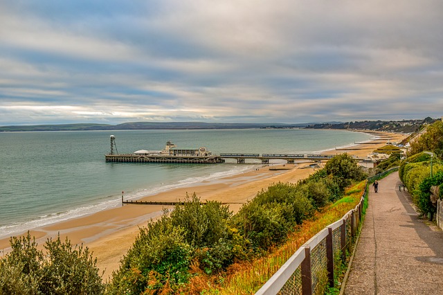
The coastline contains numerous seaside towns, with the most significant extent of coastal urbanisation along this coastal stretch being the Poole-Bournemouth urban area. With a combined population of almost half a million, this is one of the most urbanised parts of the southern English coast. Bournemouth is a very popular resort and university town, containing many amusement arcades, a pier, an aquarium, and a well-known convention centre called the Bournemouth International Centre.
Another huge attraction, however, is Bournemouth Beach, a 12 km (7 mile) long beach that stretches from Sandbanks in the west to Mudeford Point in the east [4]. With many car parks and access points, as well as being within walking distance from Bournemouth Train Station, this sandy beach is very popular with tourists, with numerous hotels in the vicinity allowing people to have holidays here. It is also backed by a row of low-lying sandy cliffs that is punctuated at various times by small valleys – this further adds to the picturesque look of the beach.
Moving eastwards from Bournemouth, the coast meets Christchurch Harbour before continuing, passing the far smaller towns of Mudeford, Barton-on-Sea and Milford-on-Sea. These are smaller residential towns which are bordered by sandy and pebbly beaches. There are also a few low-level cliffs here, although their height cannot be compared to much higher cliffs along other parts of the British coastline. This section of coastline is particularly prone to erosion. This is because the cliffs here are made up of poorly consolidated clay, sand and shingle, which do not withstand storm waves very well. Sea walls and other coastal defences have been constructed to prevent coastal erosion; however, these can be breached occasionally during coastal storm surges, such as during the January and February of 2014 [5].
At this point, not only does the coastline cross the Dorset-Hampshire border, but it also enters the New Forest National Park. Here, the coastline is much more rural – apart from the small town of Lymington, only a handful of coastal villages exist. Therefore, the coastline here is rather tranquil, and typically consists of mud flats, marshes, a handful of beaches and pockets of costal woodland. It is also notable that, for the New Forest section, the coastline is opposite the Isle of Wight, separated from the English mainland by a stretch of sea known as The Solent.
Particular points of interest include the Keyhaven-Pennington Marshes – tidal mudflats which are located close to the village of Keyhaven, and bordered to their west by a spit of land called Hurst Point. At the very end of this point exists an artillery fortress known as ‘Hurst Castle’ that was built by King Henry VIII in 1544. It is open to the public today, and is popular with visitors [6]. Other coastal attractions are the town of Lymington, which has a sailing and yachting club, the village of Lepe, known for its sandy beach amongst tranquil shrubland and pine trees, and the pebble beach at Calshot.
At Calshot, the coastline takes a sudden north-western turn as it meets the Southampton Water and heads inland for a few kilometres. Fed by the River Test and the River Itchen, this estuary leads up to the large port town of Southampton, an industrial centre that contains a large shipping port, as well as ferries to the Isle of Wight. Much of the estuary is not bordered by the New Forest, and in many ways could not be more unlike the coastline just to its west – the coast here is home to a large power station and the sprawling Fawley Oil Refinery. The town of Hythe is also located here, almost directly opposite Southampton.
References:
[1] https://www.dorsetlife.co.uk/2016/02/tragedy-in-poole-harbour/
[2] https://www.rspb.org.uk/reserves-and-events/reserves-a-z/arne/
[3] https://www.nationaltrust.org.uk/brownsea-island
[4] https://www.bournemouth.co.uk/things-to-do/beaches
[5] http://www.southampton.ac.uk/~imw/Milford-on-Sea.htm
[6] https://www.hurstcastle.co.uk/
Image Bournemouth: Dimitris Vetsikas on Pixabay