
Although the Somerset coastline begins around 20km (12 miles) to the west of the town of Minehead, this article covers the Somerset coast from Minehead to the border with Gloucestershire, and then both sides of the Severn estuary within southern Gloucestershire. As with much of the British coastline, a variety of different landscapes is encountered along this section of the coast, including rocky cliffs, headlands, bays and marshlands. Seaside towns, ports and industrial activity are also found along this coastline.
The article starts at the seaside town of Minehead. A traditional seaside town, Minehead consists of many independent shops and pubs, with hotels and a large holiday camp. With the hills of Exmoor very visible to the west, Minehead is situated on a lowland area. A long, sandy beach stretches out into the Bristol Channel during low tide [1]. A few miles west, along the coast, is the small seaside town of Watchet. Another popular tourist destination, Watchet has an even more picturesque and traditional feel to it than Minehead, and includes a small harbour and a marina [2].
Moving westwards, the coastline starts to turn rocky, with the sandstone and gritstone cliffs growing in size, and the sandy beach being replaced with rocky outcrops. This is most notable at Saint Audrie’s Bay, where a small waterfall flows down the rugged cliffs. However, the cliffs soon peter out, and around Bridgwater Bay, the coastline is dominated once again by lowland terrain, marshland and the largest tidal saltmarsh in Somerset. The large Bridgwater Bay nature reserve occupies much of this bay and the surrounding coastal marshlands, and high numbers of wild fowl and wading birds can be spotted here [3].
On the western edge of the bay, on the other side of the River Parrett estuary, is the seaside town of Burnham-on-Sea. Moving northwards from Burnham, past the village of Brean, the coastline is bordered by an area of sand dunes called the Berrow Dunes. A large portion of the dunes has been designated as a nature reserve, which is part of a much larger Site of Special Scientific Interest covering much of the sandy coastline between Burnham and Brean Down. This tranquil setting has a high level of plant biodiversity – over 270 different plant species have been recorded here, some of which are rather rare [4]. To the north of Brean is a 100 metre (300 foot) high promontory known as Brean Down, a narrow, steep and rocky limestone feature that marks the northern limit of Bridgwater Bay.
The Somerset coastline between Brean Down, and the town of Portishead located around 25 km (18 miles) to the north-east, consists of a rather rhythmic regime, where a headland is followed by a bay, which is in turn followed by another headland, and so on. This is due to harder less erosive bands of rock meeting the coastline at various intervals, between which more erosive rock has been eroded away at a faster point, leaving only lowland terrain behind. For example, between Blean Down and another headland known as Anchor Head, a large bay exists that is bordered by a large area of extensive sandy beaches, called Weston Bay.
This bay is bordered by the large seaside resort town of Weston-super-Mare. Containing a large pier called the ‘Grand Pier’, an extensive promenade, many Victorian-era hotels and guesthouses, and a wide choice of pubs and restaurants, Weston-super-Mare is very popular with visitors. Another notable feature is the disused and closed Birnbeck Pier – stretching from Anchor Head, located just to the north of Weston-super-Mare, this pier is unique in that it links the mainland with a small rocky island. Unfortunately, the pier closed in 1994, and all that remains are rotting timbers [5]. Anchor Head marks the start of the Severn estuary – the sea to the north-east of here is no longer named the Bristol Channel.
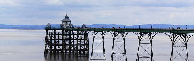
North of Weston-super-Mare and Anchor Head, the terrain shifts from low-lying to headland promontory a few times. The small seaside town of Clevedon exists in one of these bays – this is a rather quaint Victorian-era town that contains many restaurants and hotels, as well as a small pier that stretches out into the bay. The seaside town of Portishead is located a few miles to the north-east of Clevedon. However, due to the recent regeneration of a once industrial landscape, Portishead has a rather more modern feel to it, with seaside apartments and a yachting marina being constructed over the past 20 years.
The mouth of the River Avon is located just to the north-east of Portishead – appropriately named ‘Avonmouth’, this area has a great deal of industrial heritage, with docklands still existing in this area today. Warehouses and even a power station also line the low-lying coastline here, with the tall Second Severn Bridge, built to replace the older Severn Bridge in the early 1990s, rising prominently above the surrounding buildings and coastline.
The remainder of the Severn estuary – between the village of Aust and the head of the estuary close to the towns of Frampton-on-Severn and Newnham, consists of a rather uniform coastline. It is mainly bordered by a rural landscape, with the Gloucestershire countryside bordering both sides of this section of the Severn estuary. Low-level farmland and occasional marshland exist directly adjacent to the rapidly narrowing estuarine channel.
The original Severn Bridge crosses the estuary at Aust; opened in 1966, this is one of the earliest large-scale motorway bridge crossings constructed in the United Kingdom, and it was built to connect Bristol and southern England with South Wales. However, this section of the Severn estuary is also famous for a rather unusual natural phenomenon – the Severn Bore. This is a large surge wave which is particularly noticeable during rather high spring tides – due to the rapidly constricting funnel shape of the estuary, and the rather large tidal range in the Seven estuary (the second highest in the world), when the tide moves in, the terrain constricts the water, producing a small tidal wave-type feature that can reach as high as 7.5 metres (25 feet).
The countries of Wales and England meet on the north side of the Severn estuary, just south of the historic Welsh town of Chepstow, close to where the Severn Bridge intercepts the northern side of the estuary. The border runs down through the middle of the River Wye, which flows into the Severn at this point.
References
[1] https://www.visit-exmoor.co.uk/point-of-interest/minehead
[2] https://www.visitsomerset.co.uk/discover-somerset/towns-villages/west-somerset/watchet-(1)
[3] https://www.somerset-life.co.uk/out-about/wildlife/somerset-nature-reserves-1-6514767
[4] https://www.uksouthwest.net/somerset/berrow-dunes/
[5] http://www.birnbeck-pier.co.uk/
Image Clevedon by Pete Linforth