
Starting at the fishing town of Peterhead on the eastern coast of Aberdeenshire, and ending at the historic cathedral city of Inverness, this coastal stretch contains many miles of tranquillity. There is a great natural landscape that includes cliffs, as well as large sandy beaches, sand dunes and coastal forests.
Peterhead to Fraserburgh
The stretch of coastline between the port towns of Peterhead and Fraserburgh mainly consists of long and sandy bays that are backed by sand dunes and interspersed by occasional low headlands. These include the extensive Rattay Beach that extends for 27 km (17 miles) between Peterhead and the small seaside village of St. Combs – with some of the dunes reaching up to 23 metres (75 feet) high, this is an ideal place to visit if you like beach walks in a remote setting. Of the several low-level promontories jutting out into the North Sea, one of these is Rattay Head – located in the middle of two sections of Rattay beach, a lighthouse sits on a rock at the end of it, warning boats to stay away and therefore not run aground. However, another natural feature is located behind the dunes just to the south of St. Combs – the Loch of Strathbeg. As Britain’s largest dune loch, The Royal Society for the Protection of Birds estimates that up to fifth of the world’s pink-footed goose population uses Strathbeg as a wintering and staging post [1].
Three settlements are located on this coastal stretch: St. Combs, Inverallochy and Fraserburgh. The first two are small quiet fishing villages, with Inverallochy including Maggie’s Hoosie, a former fisherwoman’s cottage which is used today as a museum to showcase her life and that of the fishing community [2]. However, located at the far north-eastern corner of Aberdeenshire, the town of Fraserburgh is a lot larger. With the largest shellfish port in Europe, it has a rather busy commercial harbour, and contains various tourism-related amenities as well, including pubs, restaurants and hotels. The town is flanked by Fraserburgh Bay and its sandy beach to its east, and a rocky promontory named Kinnaird Head to the north, upon which sits the first ever lighthouse to be built in Scotland [3].
Fraserburgh to Banff
To the west of Fraserburgh, the shoreline steadily becomes more rockier, until towering cliffs dominate the coastline. As expected, tall headland promontories, rock stacks and small enclosed coves dominate the northern Aberdeenshire shoreline, with rural farmland and gorse bushes making up much of the hillsides above the cliffs. The large Troup Head promontory provides great views of the cliffs to both the east and west, as well as across the North Sea. A designated nature reserve, Troup Head is habitat to many bird species, including kittiwakes, guillemots and puffins [4]. The giant cliffs at More Head and Pennan Head also symbolise this great landscape. Of the many coves along this stretch, the picture-postcard Pennan Bay sits sandwiched between two large headlands, with a large extent of rugged rocks exposed during low tide. Other coves include Downie Bay and Old Haven.
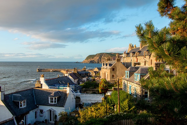
The port village of Gardenstown sweeps down from the hillside to the harbour, with the beautiful rolling scenery and large adjacent cliffs making this an ideal place to visit [5]. Although fishing is the main industry of many coastal settlements along the eastern Scotland coast, the town of Banff – located around 11 km (7 miles) to the east of Gardenstown – is renowned more for its history. The town is host to Banff Castle – a former royal castle that is used today as an arts venue, several townhouses, and a museum that was donated to the town by Andrew Carnegie. The historic harbour has been preserved, and is used today as a marina [6]. Macduff, a more traditional fishing town than Banff, sits opposite the River Deveron that borders both towns.
Banff to Inverness
Between Banff and the town of Burghead, 57 km (35 miles) to the west, the cliffs become tamer, but retain a landscape mainly consisting of the usual: rugged cliffs, grand headlands, rocky coves and sandy bays. Fishing villages lay dotted about on the North Sea coast, which, as one travels westwards, changes from Aberdeenshire to the County of Moray. The small towns of Portsoy, Cullen, Findochty and Burghead mainly consist of traditional fishing cottages huddled around a traditional stone-clad harbour. The larger towns of Buckie and Lossiemouth contain a wider range of shops, cafes and hotels than the other towns, but one industry still remains in these towns – fishing.
Moving westwards, the cliffs slowly peter out, and begin to be replaced by wide and sweeping sandy bays that are backed by vast low-lying areas of land, including sand dunes and conifer forests. Burghead Bay extends from the town of Burghead towards the village of Findhorn, its extensive sandy beach and sand dunes providing an interesting landscape for tourists. Seals are sometimes spotted on the shoreline, suing the sand flats as a habitat [7]. The village of Findhorn is a tranquil settlement that overlooks Findhorn Bay, a tidal inlet that consists mainly of mudflats at low tide, and gives great views of the Scottish Highlands in the distance towards the south and west. West of Findhorn Bay, sand dunes and extensive sand flats remain. However, behind the shoreline, the vast Culbin Forest dominates the landscape. A location suitable for peaceful walks and long bike rides, Culbin Forest is a beautiful place to visit for relaxation.
The coastline between Culbin Forest and the city of Inverness consists of a similar landscape; although the forests decrease in size, intermittent sand dunes, sandy beaches and salt marshes line the coast. The shoreline now borders the Moray Firth – the sea is named the North Sea no more. Passing the town of Nairn, great views can be seen of the hills and cliffs to the north. A massive army base named Fort George sits intimidatingly on a low-lying promontory; built in the 18th Century, this was constructed to protect the port of Inverness (and northern Scotland) from invasion, and is open to the public [8]. The cathedral city and port of Inverness sits at the head of Moray Firth – this thriving city contains a great deal of history and many shops and restaurants. As well as being at the mouth of the River Ness, a river that flows from the world-famous Loch Ness, Inverness is perhaps also well-known for its beautiful red sandstone castle that that overlooks the River Ness, and for its cathedral and university [9]. Right to the north of the town, the impressive Kessock Bridge carries the A9 dual carriageway, linking the Inverness side of the Moray Firth with the northern side.
References
[1] https://www.rspb.org.uk/reserves-and-events/reserves-a-z/loch-of-strathbeg/
[2] https://www.visitabdn.com/listing/maggies-hoosie
[3] https://www.visitscotland.com/info/towns-villages/fraserburgh-p238061
[4] https://www.rspb.org.uk/reserves-and-events/reserves-a-z/troup-head/
[5] http://www.discovergardenstown.co.uk/
[6] https://www.visitscotland.com/info/towns-villages/banff-p238141
[7] https://www.visitscotland.com/info/towns-villages/burghead-bay-p313821
[8] https://www.historicenvironment.scot/visit-a-place/places/fort-george/history/
[9] https://www.visitscotland.com/info/towns-villages/inverness-p236801
Image “Gardentown” DragonTools on Pixabay