
Consisting of cliffs, headlands, small bays and some rather historic landmarks, this Northumberland coast is one of Britain’s more interesting and scenic coastlines. Starting just north of Whitley Bay in the south and ending at the England/Scotland border in the north, this coastline borders the North Sea, and encounters several rivers that flow from the Pennine and Cheviot Hills inland into the sea. It is therefore no surprise that a large portion of the Northumberland coast has been designated as an Area of Outstanding Natural Beauty.
Starting at the Northumberland/Tyne & Wear county border and moving northwards, low cliffs wind around the sea village of Seaton Sluice before flattening out, leaving an extensive sandy beach that stretches 8 km (5 miles) up towards the port town of Blyth. As is common along much of the British coastline, the coastal landscape changes from cliffs to sandy beaches and flat land area rather frequently along the Northumberland coast.
Blyth is a small port town that, even in the age of post-industrialisation, still maintains a series of docks and numerous warehouses that stretch along the coast and up the River Blyth estuary for a couple of kilometres. 5km (3 miles) up the coastline is the more traditional seaside town of Newbiggin, which contains a sandy beach, as well as the usual small hotels, pubs and restaurants. A sculpture of a couple is positioned on a breakwater, constructed a short distance into the bay, in order to help with protecting the beach from coastal erosion [1].
Between Newbiggin and the next seaside town of Amble, the coast continues to interchange between long, sandy beaches, and small headlands that reach out into the North Sea. The majority of this stretch is occupied by a 12 km (7 mile) long sandy beach bordering Druridge Bay; this beach is popular for walking, cycling, paddling and surfing. The dunes backing the beach are rich in wildlife, and a country park located towards the northern end of the bay contains several small nature reserves that add to the biodiversity of this area [2]. Amble is a small town just to the north of Druridge Bay – bordering the North Sea on its eastern side and the River Cocquet estuary to its north, Amble is popular for its sailing, kayaking and canoeing activities. It also serves as a fishing town [3].
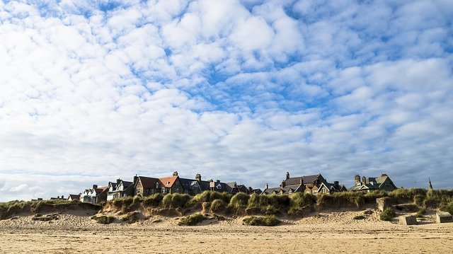
North of the River Coquet, the beach once again resembles the landscape found at Druridge Bay – a long and extensive stretch of sand that is a rather scenic spot for visitors. This expanse of sand includes Alnmouth Beach, behind which sits the picturesque village of Alnmouth. Founded in 1150, the village includes picture postcard-like cottages, as well as many pubs, restaurants, hotels and various independent shops [4]. It is therefore no surprise that the long expanse of coastline between Amble and the historic town of Berwick (covered towards the end of the article) is designated as an Area of Outstanding Natural Beauty.
The coastline north of Alnmouth is rather rugged, quickly alternating between rocky cliffs and sandy bays. There are also sections along the coast where, at times of low tide, the sea exposes large expanses of rocks that contain many rockpools. Small and scenic villages can also be found, such as Craster, Benthall and Seahouses. Castle ruins also exist along this part of the coast, including the remains of Dunstanburgh Castle – located just to the north of Craster, this 14th-Century castle is located on a low headland amongst a very impressive landscape. The remains of this castle include a gatehouse and the rather imposing Lilburn Tower [5].
Castles are a prominent feature along the Northumberland coast, in part due to its close proximity with the border between England and Scotland. Bamburgh Castle is located near the village of Bamburgh – unlike Dunstanburgh, this castle is in a far more pristine condition. With parts of the castle dating back 1,400 years, it was the home of various kings, including Henry VI and James I. The Victorian industrialist William Armstrong bought the ancient building in 1894, transforming it into an archetypal castle. Not only does the building serve as a museum of his art collection, but it is also an ancient landmark in its own right [6].
There are other ancient ruins along this stretch of coastline, such as on Holy Island. An island during high tide only, Holy Island is a rather rugged isle located only 1km (1000 yards) from the mainland. Lindisfarne Castle is located towards the south-west of the island – completed in 1570, the castle is perched on top of a steep and rugged hill. It was used by soldiers as a fortress for the next three centuries; however, during the early 20th Century, it was renovated into a holiday home [7]. An even more impressive feature on this island is the 1,400-year-old ruins of Lindisfarne Priory. An important centre of early English Christianity, this site was established as a monastery at around 635 AD. Although the priory has long since fallen into disrepair, these ancient ruins have remained untouched since their construction [8].
With regards to the coastline around the island, a large extent of tidal flats exists between Holy Island and the mainland, with a modern causeway and an ancient pilgrimage route linking the island with the mainland at low tide. The tidal flats, marshlands and dunes create a place that is an ideal habitat for a high number of visiting birds during the autumn and winter, as well as various summer dune flowers. Due to the high biodiversity in this area, as well as the very scenic and tranquil landscape, this part of the coastline has been designated as a nature reserve [9].
Moving northwards towards Scotland, one more importance place of interest is located before reaching the border – the historic town of Berwick-upon-Tweed. Located where the River Tweed meets the North Sea, Berwick was at the centre of conflict for many hundreds of years up until the late 17th Century, and it changed from being ruled by England and Scotland numerous times [10]. Therefore, much of the historic town centre is surrounded by a large 16th Century wall built to defend the town from any invading armies. Small towers were also constructed to provide extra defence, including Coxon’s Tower, which overlooks the mouth of the River Tweed as it flows into the North Sea. A historical barracks is also located within the fortifications [10]. Berwick itself consists of many picturesque cottages and town houses, and contains many pubs, restaurants, hotels and independent shops that attract many visitors.
Berwick is located around 4km from the England/Scotland border. Along the clifftop footpath, located just north of Marshall Meadows Bay, a sign marks the exact location of the border between the two nations, welcoming people into Scotland from the English side and vice versa. This is also the most northerly part of England, as well as the county of Northumberland.
References
[1] https://www.visitnorthumberland.com/newbiggin-by-the-sea
[2] https://www.visitnorthumberland.com/great-outdoors/druridge-bay-country-park
[3] http://www.yournorthumberland.co.uk/area-guides/amble
[4] http://www.yournorthumberland.co.uk/area-guides/alnmouth
[5] https://www.visitnorthumberland.com/historic-sites/dunstanburgh-castle
[6] https://www.bamburghcastle.com/castle/
[7] https://www.nationaltrust.org.uk/lindisfarne-castle/features/the-castle-peeling-back-the-layers
[8] https://www.english-heritage.org.uk/visit/places/lindisfarne-priory/History/
[10] https://www.english-heritage.org.uk/visit/places/berwick-upon-tweed-castle-and-ramparts/history/
Image Alnmouth: Michaela Wenzler on Pixabay