
With a vast expanse of incredible coastal scenery that includes spectacular cliff formations, mountains and sandy bays, the 10 walks listed in this article arguably pass some of the most amazing Scottish coastal landscapes. Although these 10 walks provide some rather spectacular views, they are by no means the limit as to what Scotland has to offer – many other coastal walks are also worth visiting.
Although there is no coastal walk that surrounds the entirety of Scotland, there are many existing coastal paths along sections of the coastline, including the John O’Groats trail – a 235 km (147 mile) long distance path that starts in Inverness and ends at John O’Groats – and the 161 km (100 mile) long Ayrshire Coastal Path which spans the coastline of the county of Ayrshire. In addition, plans are afoot to eventually link all of the coastal paths together, and to create the Scottish Coastal Way – a long distance trail that would follow the entire coastline of Scotland – by 2030.
Although these descriptions are accurate, you may also wish to check out relevant Ordnance Survey maps in advance, for a more detailed look at the route the paths take.
- Arbroath Cliffs Walk, Angus
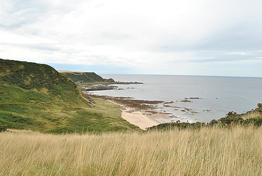
The Arbroath Cliffs is a section of red-sandstone cliffs that border the Scottish county of Angus, within a rather quiet landscape that is away from large tourist attractions. With a selection of sea stacks, natural sea arches and caves – all located within a rather tranquil and beautiful coastal setting – the coastline here is definitely worth visiting. This walk sets off from the south-western end of the Arbroath Cliffs, and carries on to the small fishing village of Auchmithie before turning back via the same route you travelled to the village.
Starting at Arbroath Cliffs car park, walk immediately along the coastline via the path that runs on top of the cliffs in an easterly direction. After around 400 metres (440 yards) of walking, you will reach the rugged section of the Arbroath Cliffs, with their distinctive red sandstone outcrops being interspersed with many small but rugged coves and inlets. This section of the walk passes the Needle E’e – a natural arch carved away by the sea over many years. Since the cliffs at this section of the walk are rather low (reaching up to 25 metres (80 feet) in height), access to both the arch and the beach is relatively easy.
The walk continues to wind its way around the rugged inlets, including Dickmont’s Den, and then past numerous sea stacks towards Carlingheugh Bay. Here, the shingle beach is accessible to walkers, and at low tide, a large area of dark rocks extends out into the bay, contrasting with the reddish hue of the cliffs. The south-western side of the bay is bordered by the Three Sisters rock stacks. The walk continues north-eastwards, with large fields to the left and the cliffs to the right. After swerving around Castlesea Bay, the walk reaches the quiet fishing village of Auchmithie. A lane connects the village with a small harbour.
To return to the start point, retrace your steps back to the car park, allowing you to take in the coastline once again.
How to find it:
Arbroath Cliffs car park is located at the eastern end of King’s Drive, around 1.6 km (1 mile) to the east of Arbroath town centre. The A92 runs through Arbroath. Co-ordinates: 56.561156, -2.557287
Length:
8.4 km/5.2 miles

Cliffs near Arbroath
By Yottanesia, CC BY-SA 3.0, https://commons.wikimedia.org/w/index.php?curid=33659228

The Needle E’e
By Yottanesia, CC BY-SA 3.0, https://commons.wikimedia.org/w/index.php?curid=33659230
- John O’Groats and Duncansby Head
This walk borders the extreme north-eastern part of the Scottish coastline, from the village of John O’Groats to Duncansby Head. With a wild and rocky coastline that includes towering cliffs and the tranquil Bay of Sannick, this makes for an interesting walk.
The walk starts at the John O’Groats car park – located just north of the village of the same name, this is one of the most northerly places on the Scottish mainland. Walk the 80 metres (88 yards) from the car park to the coastline, where you will see the small harbour that provides ferries to the Orkney Islands. From here, follow the coastal path in an easterly direction. No cliffs border this section of the walk, allowing easy access directly onto the beach. The walk winds past Robert’s Haven bay, a small headland, and then on to the Bay of Sannick, with its beach of grey pebbles and white sand.
To the east of the Bay of Sannick, the walk carries on to Duncansby Head. The cliffs grow in size, towering almost 60 metres (200 feet) above the sea at the headland. Dividing the Atlantic Ocean to the west from the North Sea to the south and east, this point marks the most north-easterly point of the Scottish mainland. Following the coastal path southwards for 1.6 km (1 mile) allows you to see some impressive geological features, including the spectacular Duncansby sea stacks and the large Geo of Sclaites inlet. With cliffs towering above the sea, this makes for an incredible landscape.
When you reach a fork in the paths around 1.6 km (1 mile) to the south of Duncansby Head (co-ordinates: 58.629619, -3.040265), take a right turn, which will lead you westwards back to the starting point. The footpath turns into an asphalted country lane – follow this until it ends at another road (co-ordinates: 58.636930, -3.063033), turn left here. When this other road reaches the A99 (opposite John O’Groats post office – co-ordinates: 58.637316, -3.068945), turn right, and you will return to the starting point.
How to find it:
John O’Groats Car Park is located at the northern end of the A99, just to the north of the village of the same name. Co-ordinates: 58.643230, -3.069384
Length:
7 km/4.3 miles
Duncansby sea stacks with Duncansby Head in the background

By McKarri, Hamburg, Germany – Self-photographed, CC BY-SA 2.0 de, https://commons.wikimedia.org/w/index.php?curid=32274904
- Plockton and Duncraig Castle
Situated on Scotland’s west coast, this landscape is filled with luscious coniferous woodland that sweeps down from craggy peaks to the coastal edge. As well as the beautiful village of Plockton, the grand Victorian-built Duncraig Castle sits within the wooded scenery.
The walk starts at Plockton car park – located on Loch Carron, the village of Plockton is regarded as one of the Highland’s finest, with white-painted cottages lining the seafront. The view from the car park gives a spectacular view of Loch Carron, with the giant peaks of the Scottish Highlands towering over the fjord, and on into the distance. This walk heads from the car park in a south-westerly direction down Innes Street, which leads you out of the village. After walking for around 800 metres, you will reach a small signposted footpath, located on the left of Innes Street, that leads you away from the road – walk down this pathway.
The pathway bends and leads you along the southern side of the loch, now taking you in an eastward direction. The footpath winds its way along the shoreline, lined by a large woodland. A quiet railway track borders the coastline here, managing to blend in very well with the natural surroundings. Although the path crosses the railway at some point, follow it continually eastwards until you reach Duncraig Station. A remote station nestled within the spectacular forested and rugged landscape, this provides walkers with great views of Plockton village, and across to the northern side of Loch Carron.
From here, walk up to Duncraig Castle to the east – built in the 1860s, this is planned to re-open at some time in the near future as a hotel. To return to Plockton, retrace your steps back. A small, circular route back to Plockton is also possible here via several footpaths and lanes through the woodland – consult Ordnance Survey Explorer map number 428 for details.
How to find it:
Plockton car park is located within the village of the same name – country lanes link Plockton to the A87 at Balmacara. Co-ordinates: 57.337604, -5.651060
Length:
4.8 km/3 miles (longer if circular route chosen)
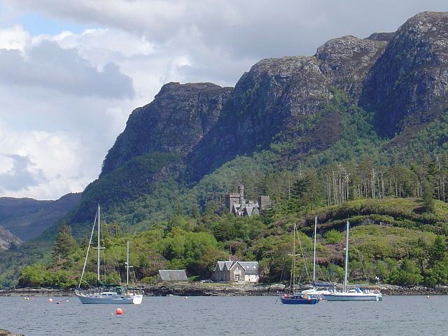
Duncraig Castle
Public Domain, https://en.wikipedia.org/w/index.php?curid=12483338
- Findlater Castle to Cullen Bay, Aberdeenshire and Moray
Crossing the boundary line between two Scottish counties, this lovely walk winds its way along the cliffs between the ruins of Findlater Castle and the traditional fishing village of Cullen. With a beautiful coastline located far from the most popular tourist areas, this is a rather undiscovered gem on the Scottish coastline.
The walk starts at the Findlater Castle car park – despite the lack of facilities such as toilets, the remote location makes this a great starting point if you are after a quiet and tranquil walk. The path stretches for 500 metres (550 yards) in a northward direction, until it reaches the top of the cliffs. From here, you can see great views of not only the North Sea, but also of the rolling landscape. Ahead of you, the 13th Century ruins of Findlater Castle lie on a grassy headland above the waves – a small path takes you onto the headland. However, this walk does not lead onto the headland, but instead winds its away around the cliffs in a westerly direction.
After around 500 metres (500 yards) of walking, the pathway descends the cliffs down into a sheltered sandy beach named Sunnyside Beach. From here to the town of Cullen, the path lies at the base of the cliffs, on a small strip of relatively flat land directly adjacent to the rocky shoreline. After winding around Logie Head and past a bay named Portlong Hythe, the path continues along the base of the cliffs through to Cullen.
When you reach Cullen Harbour, the bay of the same name unfolds in front of you, with great views across to the headland on the other side. Small fishing cottages and a large disused railway viaduct border the side of the bay, looking out to sea. Several rock stacks also lie within the bay. Although this walk follows the promenade, and ends at the beach opposite the viaduct, take a detour around the Seatown area of Cullen – filled with small stone-built and painted cottages, Seatown is a great example of a traditional Scottish fishing village. Retrace your steps to return to the starting point.
How to find it:
Findlater Castle car park is located at the end of a series of country lanes signposted from the A98. Co-ordinates: 57.686421, -2.772299
Length:
8.4 km/5.2 miles
Sunnyside Beach from Findlater Castle

By diego_cue, CC BY-SA 3.0, https://commons.wikimedia.org/w/index.php?curid=54416529
Cullen, Scotland

By Lucascullen at English Wikipedia, CC BY-SA 3.0, https://commons.wikimedia.org/w/index.php?curid=35190832
- St. Abb’s Head, Scottish Borders
With a dramatic coastal landscape that includes large headlands, coastal grass-covered hills and a freshwater loch, this walk travels through a great natural environment. The area is also a popular spot for many seabird species, who use this headland (and its surrounding coastline) as a nesting ground.
The walk starts at the National Trust for Scotland car park – from here, walk down the narrow country lane that leads to the headland. Despite being an asphalted track, the walk is a rather pleasant one which passes rolling grass and yellow gorse-covered hills. The sea comes in to full view as you near Pettico Wick bay, a small cove sheltered within the cliff faces. From here, the country lane winds its way up the hillslope up to the peak of St. Abb’s Head.
At around 90 metres (300 feet) in height, the view from the clifftops of St. Abb’s Head is incredible, with the North Sea stretching out in front of you, and the spectacular cliffs to the left of you. In the distance, the cliff faces can be seen stretching out for miles into the distance on the north-western side. The white-painted lighthouse and its cottages, situated on the top of the headland, also add further to the wild character of this landscape.
The walk now travels in a south-western direction, roughly following the clifftops over a dirt footpath as it slowly returns to the start point. Although signposted, there is a point (co-ordinates: 55.911464, -2.137814) where you may wish to leave the route and walk towards the shore of Mire Loch, a small freshwater loch that lies to the south of the headland. Re-joining the main route carries you over rugged and hilly terrain, passing the head of several rocky coves on its way. When the path reaches a road (the B6438), turn right and you will reach the car park you started at.
How to find it:
The National Trust for Scotland car park is located on the B6438 – follow the sign directing you to the St. Abb’s Head Nature Reserve before you enter the village of St. Abb’s. Co-ordinates: 55.899627, -2.140626
Length:
5 km/3.1 miles
St Abbs Head from St Abbs

By Mick Knapton – Self-photographed, Public Domain, https://commons.wikimedia.org/w/index.php?curid=4569493

St Abbs Lighthouse
By Lisa Jarvis, CC BY-SA 2.0, https://commons.wikimedia.org/w/index.php?curid=13136083
- Achmelvich Bay, Scottish Highlands
Despite being located on the west coast of the Scottish Highlands, the scenery at and around Achmelvich Bay is not surrounded by dramatic landscapes of mountains, but instead of an even more intriguing environment. Grassy hillocks loaded with craggy granite outcrops rise up from the ground both along the coastline and within the large area behind it, giving this location an incredibly wild feel to it. Despite its location, the sea within Achmelvich Bay has an almost turquoise hue to it, with its Blue Flag award-winning white sandy beach, almost has a Mediterranean feel to it.
Many walks in this guide have included a set walk guiding visitors around a trail – however, at this location, it is probably better to explore and take in the landscape without a specified route. Use Ordnance Survey Explorer map number 442 for guidance.
The car park is located around 150 metres (160 yards) to the east of Achmelvich Bay – the walk to the beautiful, white and sandy shoreline is very easy – across open grasslands. Small pathways are scattered across the rugged granite headlands that flank both sides of the bay, which take you over and around these grassy outcrops, along the rocky coastline on each side. On the southern headland, a 350 metre (380 yard) walk in a westward direction brings you to the so-called ‘Hermit’s Castle’ – reputed to be Europe’s smallest castle, the structure was built in the 1950s by an English architect named David Scott. Its intended purpose is unknown.
North of the bay, the coastline weaves around rugged headlands and occasional sandy coves. The lack of tall cliffs, however, allows relatively easy access to the shoreline, but take precautions due to the rocky nature of the area. A 3.2 km (2 mile) walk takes you along a footpath that winds its way over granite hillocks, and then along the quiet B869 road to the Bay of Clachtoll, another rather scenic sandy cove. To return to Achmelvich Bay, retrace your steps back along the road and the footpath.
How to find it:
Achmelvich Beach car park is located near the western end of a small country lane that turns off from the B869 – the B-road itself turns off of the A837 just before you reach Lochinver. Co-ordinates: 58.169506, -5.301882
.jpg)
Achmelvich Bay
By Mr Raikage – Own work, CC BY-SA 3.0, https://commons.wikimedia.org/w/index.php?curid=4397748

Achmelvich Beach
By michael hardman, CC BY-SA 2.0, https://commons.wikimedia.org/w/index.php?curid=9183550
- Dunure to Culzean Castle
Stretching down the western coast of Ayrshire, this walk starts at the small coastal village of Denure, passing clifftops and the long, sandy beach of Culzean Bay, before ending up at the spectacular Culzean Castle. Despite being around 14 km (8.7 miles) in length, this walk is certain worth taking if you are looking for an incredibly scenic environment.
Starting at Denure car park, which is located within Kennedy Park, this walk follows the Ayrshire Coast Path southwards along the clifftops. As well as the cliffs to your right and the hillslopes to the left, many thickets of distinctive yellow-flowered gorse bushes are also visible. After walking for 700 metres (770 yards), the path reaches the top of a hill – from here, you can see amazing views of Culzean Bay stretching out into the distance.
The coast path slowly drops down into the bay, winding its way around the cliffs as it does so. The path reaches Croyburnfoot – although the only amenities here are parking and toilets, an impressive 2.5 km (1.6 mile) long sandy beach stretches from here towards Culzean Castle. Looking slightly to your right, the distant peaks of the Isle of Arran rise from the waves – slightly to your left lies Ailsa Craig, a lone island located 20 km (12.4 miles) from the shoreline.
The walk continues southward along the Ayrshire Coast Path, bordering the shoreline. After passing a small beach named Maybole Beach, the walk winds past the beach, underneath beautiful tree-lined cliffs. Small streams – or ‘burns’ – rush down the cliffs through small valleys that have been carved out incrementally over many years. Before reaching Culzean Castle, the path winds its way up the hillslope.
After the climb, you reach the castle. Built in the late 18th Century, Culzean Castle is now owned by the National Trust for Scotland, and is surrounded by a large country park that includes a walled garden and a lake named Swan Pond. A popular tourist attraction, there are also amenities available such as refreshments and toilet facilities.
To return to the starting point, retrace your steps back along the Ayrshire Coast Path.
How to find it:
Denure car park is located within Kennedy Park in the village of Denure. Two country lanes link the village with the A719. Co-ordinates: 55.404168, -4.762045
If you would like to take a shorter walk to Culzean Castle, use Croyburnfoot car park (co-ordinates: 55.374865, -4.76929054399837) or any of the car parks in Culzean Country Park (co-ordinates: 55.356102, -4.780403)
Length:
Denure to Culzean Castle and back – 14 km (8.7 miles)
(Croyburnfoot to Culzean Castle and back – 5.6 km (3.5 miles))

Culzean Castle on the left, with Culzean Bay stretching out into the distance
By Julien.scavini – Own work, CC BY-SA 4.0, https://commons.wikimedia.org/w/index.php?curid=88457312
- Loch Linnhe and Castle Stalker, Argyll and Bute
This trail passes a short section of the eastern shore of Loch Linnhe, providing walkers with a great snapshot of nearby Shuna Island, and of the Kingairloch mountain peaks on the other side. The southern part of the walk passes the smaller Loch Laich inlet – within it, Castle Stalker stands on a small and rocky island.
The walk starts at Linnhe Marine car park, located alongside the A828 road around 1.5 km (0.9 miles) to the north of the village of Portnacroish. The walk follows a paved path, taking you from the car park in a southerly direction. A former railway track, the path borders Loch Linnhe, from which you can see Shuna Island, which lies within the loch to the west. Looking northwards up the loch, the mountains of the Kingairloch range are visible in the distance, their grey and jagged peaks only adding to an already incredible landscape.
After around 1.2 km (0.7 miles) of walking, you will reach a small cove which forms a part of Loch Laich, a small inlet which spurs off from its parent, Loch Linnhe. Ahead of you lies Castle Stalker – surrounded by water on all sides, this magnificent stone tower house dates back to Medieval times. The track curves around the northern side of Loch Laich, past Portnacroish and into the Straith of Appen, a valley (or glen) that runs through to Loch Creeran. However, this walk does not follow it any further than the eastern reaches of Loch Laich.
However, there is still one part of the walk left. This walk leaves the main path and crosses the eastern saltmarshes of Loch Laich via a small wooded bridge. Built in 1898, this crossing was named ‘Jubilee Bridge’ to commemorate the Diamond Jubilee of Queen Victoria. This part of the walk is not only worth it for the bridge, however, but also for the amazing views across Loch Laich – including of Castle Stalker – to the west. Looking to the east provides stunning views of the Strath of Appin, with the bare and rugged hills on the left-hand side, and the green and wooded slopes to the right. Follow the footpath onto the southern side of Loch Laich, where it meets a country lane at the small hamlet of Taychreggan.
This is the end of the walk – retrace your steps to return to the car park. However, you may wish to walk the additional distance to the village of Port Appin, around 2 km (1.2 miles) to the south-west of Taycreggan, or along the disused railway path through the Strath of Appin to the shore of Loch Creran, located around 4.5 km (2.8 miles) to the west of Portnacroish.
How to find it:
Linnhe Marine car park is located alongside the A828 and the shoreline of Loch Linnhe, around 1.5 km (0.9 miles) to the north of Portnacroish. Co-ordinates: 56.588957, -5.373717
Length:
Loch Linnhe to Taycreggan and back – 6 km (3.7 miles)

Castle Stalker
By Gil Cavalcanti – Own work, CC BY-SA 3.0, https://commons.wikimedia.org/w/index.php?curid=7485203
- Stac Pollaidh, Scottish Highlands
Stac Pollaidh is a lone 612 metre (2,007 foot) high peak that rises from the rocky Scottish moorland. Located alongside Loch Lurgainn, the peak is fairly popular with tourists due to its relatively low prominence compared to other mountains, and for the spectacular views of the surrounding area, including of the coastline to the north-west. This walk does not climb the peak, but instead follows a ring path around the tallest section – however, it still takes you over 450 metres (1,500 feet) above sea level.
The walk starts at Stac Pollaidh car park. The path leaves the car park on the other side of the country lane, through a wooden gate. From here, the incredibly rugged peak stands in front of you. After a short 200 metre (220 yard) long walk up the lower slopes, the path diverges into a fork – take the path on the left, which takes you up onto the western slopes of the mountain.
The steep climb up the western side is superb – not only for the great views of Loch Lurgainn to the south, but also of Stac Pollaidh to the north-west. This section gives walkers a great view of the peak – not just of the spectacular rocky crest that makes up the upper slopes, but also of the large scree slope that runs down from the rugged top down the southern side. During the last Ice Age, the lower slopes of the peak were sculpted into shape by glaciers, while the top was exposed above the ice.
Curving around the peak onto its north-west and northern side, the walk crosses the highest section. Reaching heights up to 490 metres (1,600 feet) above sea level, the path at this point provides spectacular views across to the coast at Enard Bay, located a few miles to the north-west. Continue in an eastward direction, with the peak of Stac Pollaidh now to your south. At some point, you will reach a fork in the path – do not climb the mountain further (the right-hand path) – instead, continue walking forwards. The climb to the summit is only recommended for more experienced walkers.
Continue walking past the eastern side of the peak, which provides you with superb views of the Cul Mor mountain to the north-east. The path continues to take you down the slopes to the starting point, which is located to the south.
How to find it:
Stac Pollaidh car park is located on a small country lane that leaves the A835 at Drumrunie. Co-ordinates: 58.034539, -5.207226
Length:
3.5 km/2.2 miles

Stac Pollaidh
By Mehmet Karatay – Own work, CC BY-SA 3.0, https://commons.wikimedia.org/w/index.php?curid=4181150

Stac Pollaidh crest
By The original uploader was Grinner at English Wikipedia. – Transferred from en.wikipedia to Commons by Kurpfalzbilder.de using CommonsHelper., CC BY-SA 3.0, https://commons.wikimedia.org/w/index.php?curid=9703645
- Mull of Kintyre, Argyll and Bute
Marking the south-westerly end of the Kintyre Peninsula, and even immortalised in a song by Paul McCartney, the Mull of Kintyre provides spectacular views across the North Channel sea. This walk climbs down a large hillside at the tip of the peninsula towards the clifftops below – peaceful and scenic, this is an ideal walk if you are seeking some tranquillity.
The walk begins at the Mull of Kintyre car park – perched on the top of the hillside at around 350 metres (1,150 feet) above sea level, the starting point alone gives you an amazing view of the North Channel sea. To your left and right, the rolling craggy hills slide down towards the sea, adding to the spectacular landscape. The walk follows a small asphalted country track that winds down towards a lighthouse, which sits perched atop the clifftops that mark the limit of the peninsula. With sea fog a frequent occurrence here, the Mull of Kintyre lighthouse is a well-needed building for which many sailors have felt grateful towards over the years.
The route winds down the hillslope towards the lighthouse – a white-painted building that is unfortunately not open to the public as a museum, it sits within its own fenced enclosure. Here, stop to take in the view along the coastline, where the rocky steep slopes of the peninsula unfold into the distance. On a clear and sunny day, the hills of Northern Ireland can be seen to the south-west. Apart from the lighthouse building, this is a very remote place. It is not popular with tourists, even during the first two weeks of August.
From here, you may wish to return back to the car park – however, there is another section of the walk which is recommended. Just before reaching the lighthouse (co-ordinates: 55.310546, -5.801168), a small path branches off from the track. This path takes you southwards along the coast for around 1 km (0.6 miles), giving you more amazing views of the hilly landscape. The route terminates at a headland named ‘Rubha na Lice’, with spectacular south-facing views of the North Channel. The spectacular cliffs of the peninsula fade into the distance towards the south-east.
The route back to the car park follows the same route that you walked here.
How to find it:
Mull of Kintyre car park is located at the end of a long country lane that leaves the B842 just before reaching the village of Southend. Co-ordinates: 55.308825, -5.786767
Length:
5.2 km/3.2 miles

Mull of Kintyre Lighthouse
By emperley3 – https://www.flickr.com/photos/emperley3/167695108/, CC BY-SA 2.0, https://commons.wikimedia.org/w/index.php?curid=2429891

Mull of Kintyre Lighthouse
By Donald MacDonald, CC BY-SA 2.0, https://commons.wikimedia.org/w/index.php?curid=11285108