
Table of Contents
Access to the coastline is rather easy in England, with much of it consisting of footpaths, and sections of it consisting of land owned by charities and organisations such as the National Trust, Natural England and local authorities, which are open to the public. Long-distance paths also border large swathes of the coast, such as the 1,000 km/630-mile-long South West Coast Path, which runs from Minehead in Somerset to Poole Harbour in Dorset. Other paths include the Cleveland Way, around half of which borders the North York Moors coastline, the Cumbria Coastal Way, and limited sections of the South Downs Way. Currently, the England Coast Path is being proposed – at 4,500 km/2,800 miles in length, this long-distance trail is planned to follow the entire coastline of England.
With a variety of different landscapes that includes sand dunes, cliffs and wide-open fields, the English coastline is not only worth visiting, but also worth walking along. Out of the many different sections of spectacular coastline, these 10 are the ones that you should definitely visit!
Although these descriptions are accurate, you may also wish to check out relevant Ordnance Survey maps in advance, for a more detailed look at the route the paths take.
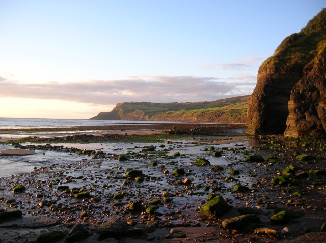
Lulworth Cove, Durdle Door and Bat’s Head, Dorset
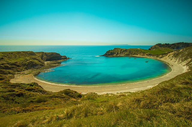
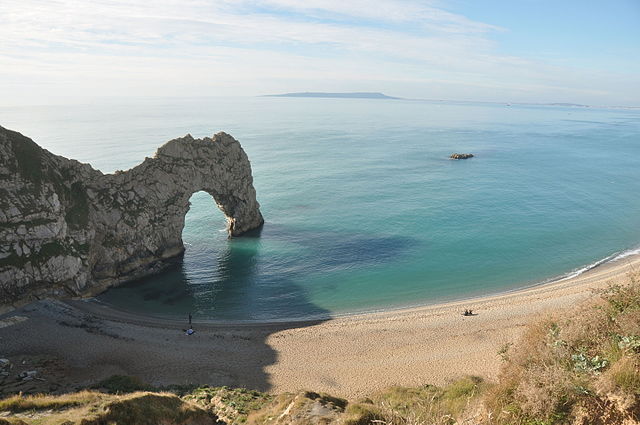
Passing a small but spectacular section of Dorset’s Jurassic Coast, this trail passes Lulworth Cove, a distinctive small cove that acts as an ideal natural harbour, and Durdle Door, one of Great Britain’s most distinctive and emblematic natural coastal arches.
Starting in the quintessentially Dorset village of Lulworth, the walk follows the route of the South West Coast Path in a westward direction, and climbs up a hill named Hambury Tout. From the hill’s summit, great views of the coastline can be seen over a vast area, with the white limestone cliffs snaking into the distance both the east and the west. To the east, Lulworth Cove can be seen very clearly.
Following the path further westwards for around 1 km, you will pass Durdle Door. The view of this natural arch is rather breath-taking. Afterwards, the walk continues to follow the South West Coast Path, taking a route along the top of the rugged cliffs and swirling sea towards Bat’s Head – a small headland which provides more great views of the coastline. To shorten the route, you may choose to turn back towards Lulworth from here – however, if you plan on making the most of this walk along the beautiful Dorset coast, then carry on walking westwards for another 1.2 km along the South West Coastal Path up another hill – Chaldon Down.
At the top of this hill, this walk leaves the South West Coastal Path, and heads eastwards along Chaldon Down. From here, great views can be seen of the coastline, and again of Durdle Door, but this time from a higher altitude. The walk passes Newlands Farm, Newlands Caravan Park, and carries on down the hill to the village of Lulworth.
Durdle Door by Nilfanion, CC BY-SA 4.0, via Wikimedia Commons
.jpg)
How to find it:
A car park is located on the B3070, just before you reach Lulworth Cove. Co-ordinates: 50.620026, -2.253198.
Length:
6 miles/10 km (3 miles/5 km if you decide to turn back at Bat’s Head)
Mousehole, Penzance & St. Michael’s Mount, Cornwall
A particularly varied coastal walk that follows only a small section of the South West Coast Path, this route will take you past rugged Cornish cliffs, fishing towns and villages, and up to the iconic island of St. Michael’s Mount.
The path starts at the beautiful village of Mousehole. Mousehole is packed with small shops, cottages, narrow streets and a quintessentially Cornish fishing harbour. Walking northwards along the South West Coast Path, one passes rocky coastline on the right, and steep hillsides to the left. From here, great views can be seen across Mount’s Bay, with St. Michael’s Mount visible to the north-west. The path will take you through Newlyn, passing a fishing harbour that is still active today.
St. Michael’s Mount by Nilfanion, CC BY-SA 4.0, via Wikimedia Commons
.jpg)
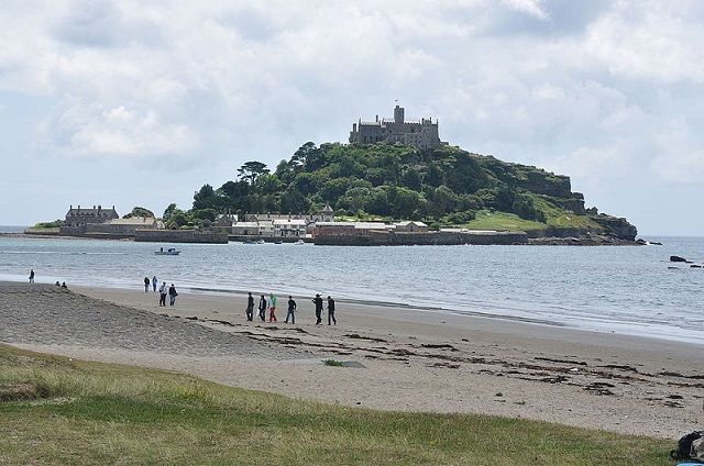
Continuing further on along the coast, you will reach Penzance, another vibrant fishing hub. Just to the south of Penzance harbour is a low-lying area of rocks known as Battery Rocks – only becoming visible during low tide, these are a hazard to boats, but protect the harbour located just to the north from storm waves.
To the west of Penzance, St. Michael’s Mount is visible in the near distance. However, before that, one must walk for around 3km (2 miles) along the northern side of Mount’s Bay, which is marked by a long, sandy beach. St. Michael’s Mount rises up from the sea, around 350 metres off from the coast, opposite the village of Marazion. Only accessible during low tide via a granite causeway, the 12th-Century priory and castle loom over the rest of the island, their grand and beautiful buildings making the island a must-see for visitors to the area.
After visiting St. Michael’s Mount, the best route to Mousehole is to travel back along the South West Coast Path.
How to find it:
A car park is located in Mousehole, on The Parade. Co-ordinates: 50.084921, -5.536320.
Length:
11 km/7 miles (5.5 km/3.5 miles if you decide to start at Penzance instead)
Mousehole, Penzance & St. Michael’s Mount, Cornwall
Following a coastal route along some of south-west England’s wildest coastline, this path starts and ends in the seaside town of Lynton, and offers some amazing views across both the Bristol Channel, and of the North Devon coast.
Starting at Bottom Meadow car park, this route walks down the narrow streets of Lynton, with its small quaint shops and tea rooms, and meets the South West Coast Path on a street named ‘North Walk Hill’. Great views can be seen from the path of the small seaside town of Lynmouth below, and of the historic Lynton and Lynmouth cliff railway.
 Janine Forbes / View of The Valley Of Rocks from Hollerday Hill
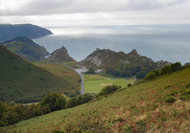
Leaving Lynmouth in a westward direction, the South West Coast Path hugs the hillside, with the sea far below to the right, and the large Hollerday Hill to the left. After walking 1.2 km, the route leaves the South West Coast Path and climbs the ridge on the left. From the top, the view is incredibly impressive, with the Valley of the Rocks to the south and west, with its heather-covered northern side, and a southern side that is made up of jagged rocks that divide the Valley from the sea to the north. This is a distinctive landform – it is an extinct river valley that is being incrementally eroded on its northern side by the stormy sea of the Bristol Channel.
The route zig-zags down into the valley itself and follows a country lane for about 500 metres, before reaching a small roundabout-type feature. A rugged rock formation known as ‘Rugged Jack’ stands in front of you, with its dramatic and craggy features. Passing this, the route runs northward, meeting the South West Coast Path, and follows the coastal hillslope back towards Lynton. This section is particularly wild – the path tightly hugs the steep coastal hillslope, with many rocky outcrops visible. The path passes Hollerday Hill, which this time is on your right, after which you are brought back to Lynton.
How to find it:
Bottom Meadow car park is located on a road named Castle Hill, which branches off of the B3234. Co-ordinates: 51.228508, -3.833418.
Length:
3 km/5 miles – some of the path is fairly rough and uneven
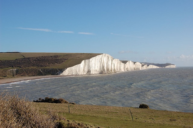
Seven Sisters, East Sussex
The Seven Sisters are a series of chalk cliffs on the southern coast of England. They are striking not only for their distinctive white colour, but also for their towering height.
A great place to start a walk along the cliffs is in the small village of Exceat – located just 1.8 km (1 mile) from the coastline, there are a few amenities here – toilets, parking facilities and refreshments. To reach the coast from here, take a walk down the beautiful Cuckmere valley, a rather wide and grassy river valley where the River Cuckmere has carved its way through the chalky South Downs. The path here is of a good quality, and when it reaches the coast at a small cove named ‘Cuckmere Haven’ – spectacular views can be seen of the chalk cliffs to the east of us. These are what are referred to as the Seven Sisters.
Seven Sisters Cliffs by By James Gardner (user Silverstorm20,) Public domain, via Wikimedia Commons
When at the coast, follow the path which runs in an eastward direction up Haven Brow, which is the first large cliff – or ‘sister’ – of the walk. On top Haven Brow, the coastal path meets the South Downs Way, which runs along the top of the cliffs. Despite the presence of tourists, this is a rather tranquil place, with the waves crashing below, and a great view of the English Channel to the south, and of the luscious rolling hills of the South Downs to the north. Walking along the top of the Seven Sisters certainly is worth it not only for the scenery, but also for the tranquillity.
After climbing up and down several small valleys, which exist between each ‘Sister’, the last hill descent takes you down into the small village of Birling Gap. A few amenities, including a café, are located here, and a small staircase offers a route down to the shingle beach below. Although you may wish to walk onwards to Beachy Head (another 7 km there and back), the walk in this article follows the same route back to Exceat, allowing you to take in the same spectacular landscape yet again.
How to find it:
The car park in Exceat is located on the A259, just to the east of Seaford. Co-ordinates: 50.776151, 0.152293
Length:
13 km/8 miles
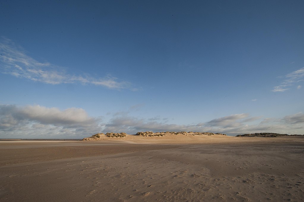
Holkham Beach, Norfolk
With a wide sandy beach, sweeping sand dunes and a pine forest, all located on the tranquil North Norfolk coast, Holkham Beach and its surrounding area is a beautiful place to visit.
The walk starts at the car park which is located at the end of Beach Road, on the eastern part of Holkham Beach. From here, follow the Norfolk Coast Path along the edge of a pine woodland for about 2km, after which you will reach Holkham Gap. With extensive farmland to the south, and pine trees to the north, this is a rather tranquil location.
Holkham Beach by Bryan Ledgard, CC BY 2.0, via Wikimedia Commons
.jpg)
At Holkham Gap, follow the coast path northwards, along a boardwalk through the trees, and onto the dunes. With a large expanse of dunes between the woodland and the sea, this is a rather interesting and unusual location to visit. Continue to follow the Norfolk Coast Path for about 3.5km, until a fork in the path is reached. Leave the Norfolk Coast Path, and follow the path to the right, which leads you onto the beach itself. The route back to the starting point follows the sandy beach, with its vast open space and impressive views of the coast and the sea.
After crossing a small stream that trickles across the sand, located to the north of Holkham gap, carry on walking along the beach, next to the dunes. As you near the starting point, a small row of beach huts borders the boundary between the sand and the woodland, each one painted in a different colour, only adding to Holkham Beach’s charm. A small concrete-paved lane links the eastern extent of Holkham Beach with the car park at the very start.
How to find it:
The car park at the end of Beach Road is located to the north of Wells-next-the-Sea, which is on the A149. Alternatively, another car park is located at Holkham Gap, at the end of Lady Anne’s Drive, which also links with the A149. Co-ordinates: 52.972318, 0.847749
Length:
10 km/6 miles
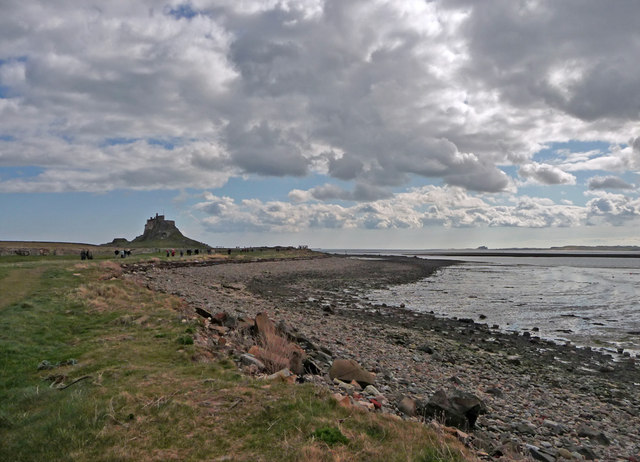
Holy Island, Northumberland
Located just off from the Northumberland coast, around 10 km to the south of Berwick, lies the rugged Holy Island, upon which sits both the Medieval priory and Lindisfarne Castle. With a varied coastline that includes rocky and sandy sections, and centuries-old landmarks, a coastal walk around the entire island is highly recommended.
The walk starts at Chare Ends car park, and takes visitors through the village of Holy Island, past lovely stone-built cottages. After walking down Chare Ends, Crossgate Lane, and to the right of the Crown and Anchor pub, you pass the ruins of Lindisfarne Priory, which loom to your right. Once you reach the coast, Lindisfarne Castle stands on a distant hill to your left. Follow the coastal path in this direction.
Lindisfarne Castle, Holy Island, Northumberland – Christine Matthews / Lindisfarne Castle, Holy Island, Northumberland
The dark and flat coastal rocks, visible when the tide is out, contrast against the luscious green grass on the island, only improving the beautifully natural landscape. Pass the towering castle to the left, and follow the coastline as it swings to a northerly direction. After walking past green fields for about 1.5km, with the rocky coastline to your right, the landscape changes – a sand dune system known as ‘The Links’ makes up the northern edge of the island’s coast. Although the main route skirts the edge of the dunes, if you fancy a longer trek, walk right up to the beach bordering the dunes, where there are three small headlands – Emmanuel Head, Castlehead Rocks and Snipe Point – all of which only add to the great scenery. The dune crests also provide great views of the surrounding area.
To the south of Snipe Point, a path will take you back from the dunes, in a southward direction, to Chare Ends car park, completing the walk.
How to find it:
Chare Ends car park is located on the only road leading into the island. This is a tidal island, with a causeway that is submerged during high tide – for two times each day. The causeway links to the A1 road just to the south of Haggerston. Co-ordinates: 55.674982, -1.800910
Length:
5 km/3 miles
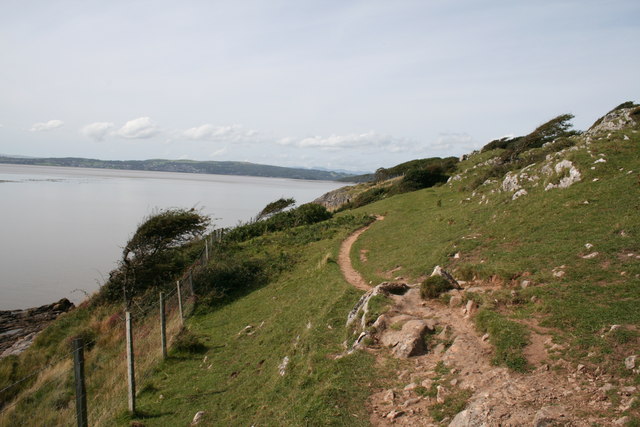
Arnside & Silverdale Coastline, Lancashire
Situated on the north-eastern coast of north-west England’s Morecambe Bay, the area surrounding the villages of Arnside and Silverdale is a beautiful area of limestone cliffs, luscious trees and vast tidal sand flats. This is a great area for spectacular views of the natural landscape.
Unlike the other locations, it is difficult to suggest a set route as there are many tracks and paths in the area, and there is a lack of car parking around here to use as a starting point. However, it is the lack of such facilities that I would argue makes this part of Great Britain rather special – it has a rather wild and ‘off-the-beaten-track’ feel to it. It is up to you to plan your own route around this beautiful area – use Ordnance Survey map ‘Explorer OL7’ for guidance.
When planning out your own route, I would suggest using Arnside Knott car park as a starting point. From here, paths run down the hill to the coastline, through luscious expanses of green deciduous trees, and over patches of limestone pavement. Blackstone Point and Arnside Point – two limestone promontories that form a small cliff face – are accessible by a coastal pathway. Although great views across Morecambe Bay can be had from the coastline, even more spectacular views can be seen from the top of Arnside Knott, a hill located just to the east of the car park. These include of the hilly coastline to the west, and of the Lake District fells to the north and north-west.
Peter Bond / Cliff path, Jack Scout
As well as the small quaint coastal villages of Arnside and Silverdale, with their quintessentially Lancastrian stone-built cottages, the coastline has more surprises to offer. Close to Silverdale, a small cave is featured in the cliff, as is common in limestone landscapes. To the south of Silverdale, points of interest include Jack Scout (an area of grassland and many limestone outcrops which provides more great views across Morecambe Bay) and a promontory named Jenny Brown’s Point (upon which a disused chimney stack sits on the shoreline).
How to find it:
Arnside Knott car park is located around 500 metres to the south-west of the village of Arnott – the B5282 connects the village with the A6. The Arnside/Silverdale area is close to the M6 Motorway. Co-ordinates: 54.188827, -2.844463
Robin Hood’s Bay, North Yorkshire
An incredibly scenic bay on the eastern side of the North York Moors, Robin Hood’s Bay is characterised by its towering cliff faces, rocky beaches, and the picturesque village which shares its name with the bay.
Raven Hall Road in Ravenscar is a great place to start the walk – located at the bay’s southern end, spectacular views can be viewed across the vast bay to Ness Point, which makes up the northern edge. Follow the Cleveland Way footpath, which takes you down the hillslope towards the bay. The Cleveland Way skirts to the east of the ruins of Peak Alum Works, and then winds its way along the clifftop. With the hills of the North York Moors to the left, and the vast North Sea to your right, this is a truly tranquil landscape to walk in.
Two small and steep wooded valleys, along which the Stoupe Beck and Mill Beck streams run down from the Moors, add to the variety of the natural landscape. The latter of these valleys – Boggle Hole – is a particular highlight of the walk, providing walkers with not only access to the rocky beach, but also with a view of the rock folds in the side of the river. The bay is also a great location for fossil hunting.
Robin Hood’s Bay, Looking Towards Ravenscar by DS Pugh / Looking towards Ravenscar
After following the clifftop for another 900 metres, you will reach the village named Robin Hood’s Bay. A beautiful seaside village with narrow, twisting streets filled with stone-built shops and small townhouses, this is another highlight of the hike. Walking up New Road takes you up to the hill to the northern side of the village, from which great views of Ravenscar, the hills of the Moors, and the rocks in the bay, can be seen. To return to Ravenscar, follow the same route back – alternatively, you may wish to extend the walk by continuing to Ness Point, and then turning back.
How to find it:
Parking is available on Raven Hall Road – the A171 runs around 4 km/2.5 miles to the west of Ravenscar
Length:
11 km/7 miles (14 km/8.7 miles if you continue to Ness Point)
Hartland Point, Devon
With a series of cliffs that tower over the rocky shoreline below, and rolling green fields, the western Devon peninsula known as ‘Hartland Point’ is a great place to walk for its spectacular landscape.
The walk starts at Hartland Point car park. With the blue sea far below, the island of Lundy out into the distance, and the luscious green landscape, the view from the car park alone is worth visiting. The route follows the South West Coast Path to the west, passing Hartland Point Coastguard Station. A viewpoint allows walkers to take in the spectacular cliffs, including those which make up the Hartland Point headland. The white lighthouse is visible at the end of it.
Hartland Point Lighthouse by Rcoh, CC BY 3.0, (own work) via Wikimedia Commons
The coastline takes a dramatic turn to the south of the headland, and the coastal path travels in a southward direction. Walking along the clifftops, the rocky beach is visible at the bottom – its grey rocks arranged in bands. This coastline is notorious for being a hazard to sailing, with shipwrecks being a once-common occurrence. The coastal path winds around small headlands before diving into a small valley and up the opposite side.
Follow the coastal path along another clifftop – known as ‘Blegbury Cliff’. From here, there is an option to follow the path down to the coast, on a small headland known as ‘Damehole Point’. This walk leaves the coastline at this point, and starts heading back to the starting point away from the coastline – however, this is also rather tranquil, as the route heads back through green fields. It travels through Blegbury Farm – 300 metres after this, it turns left down a country lane, and heads into the same river valley as was previously travelled through. It heads up the other side via Blagdon Farm, after which you will return to the car park.
How to find it:
Hartland Point car park is situated at the end of a country lane, which is accessible from the B3248 at the village of Hartland. Co-ordinates: 51.019518, -4.518306
Length: 5 km/3 miles
St. Bees Head, Cumbria
The most westerly point in the county of Cumbria, the St. Bees Head promontory juts out into the Irish Sea. Consisting of tall cliffs that peak above the waves, this is a great walk for views of the Cumbrian coastline.
A car park, situated just to the west of St. Bees village, offers a great starting point. From here, the coastal path climbs onto St. Bees Head, which is located to the west. It is a fairly smooth climb, and the path runs parallel to the top of the cliffs – this part of the headland is called ‘South Head’. Being around 100 metres high, the view across the Irish Sea is rather spectacular, and the coastline can be seen disappearing off into the distance to the south and south-east.
Fleswick Bay from the St Bees Path by Dougsim, CC BY-SA 3.0, via Wikimedia Commons
After winding around a small stream that trickles down into the sea, the coastal path once again borders the clifftops, and curves around North Head, the northern part of the promontory. As well as more great views, a tall white-painted lighthouse stands on top of the headland. To the north of this landmark, the coastline turns to a north-easterly direction, and views can now be seen of the coastline heading in a northward direction.
After passing a small quarry on the right, and reaching a small three-way junction in the paths, continue down the footpath on your right, leaving the coastline. The route back to the starting point travels through Cumbrian countryside and the village of Sandwith. To your east, the fells of the Lake District loom in the distance. When you reach a lane named ‘Main Street’ – which runs through Sandwith – take a right, and walk down it in a southward direction. After passing the village of Rottington, the path bends to the west – a footpath turns off of the bend, which returns you to the car park.
How to find it:
St. Bees Beachfront car park is located at the western end of Beach Road, accessible via the village of St. Bees. The B5345 runs through the village. Co-ordinates: 54.491231, -3.605118
Length:
9 km/5.6 miles