
Table of Contents
Wales is renowned for its spectacular coastal walks, many of which are located along the shoreline. It is therefore rather fortunate that a coastal footpath borders the whole of the Welsh coastline – the Wales Coast Path. The first path in the world to follow the coastline of an entire country, this route offers 870 miles of great views, including rocky cliffs, sheltered coves, sandy beaches, and much more.
The 10 walks in this article only travel along a small fraction of the Wales Coast Path – however, they are amongst the best coastal landscapes that Wales has to offer. A variety of different landscapes are included in these walks.
Although these descriptions are accurate, you may also wish to check out relevant Ordnance Survey maps in advance, for a more detailed look at the route the paths take.
St. David’s Head
Following the craggy Pembrokeshire coastline, this walk traverses through a beautiful landscape that includes sandy beaches, rocky coves, and a Neolithic-age burial chamber.
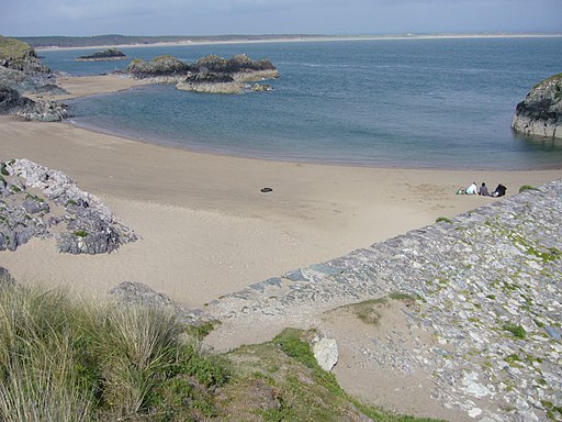
Starting at Whitesands Beach car park, the walk follows the Wales Coast Path in a northward direction, with the path closely hugging the clifftops as it winds around Porth Lleuog bay. Beautiful views of Whitesands Bay can be seen to the south. The footpath winds along the coastline for 1.2 km (0.7 miles) until it reaches Porthmelgan cove, where the walk leaves the Wales Coast Path, taking a right-hand turn after crossing a small stream. Consult an Ordnance Survey map for specific details of which path to take, as it is not signposted.
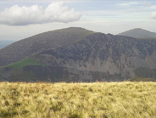
The trail moves across open moorland in a north-easterly direction for 1.1 km (0.7 miles) – to the right, ancient field patterns can be seen on the craggy 181 metre (594 foot) high flanks of Carn Llidi. Continuing to the north-east will take you back to the Wales Coast Path – when you reach this, turn left. With the vast open Irish Sea stretching out to the north, great rocky crags along the clifftops only add to this already spectacular landscape.
Following the Wales Coast Path for around 1.5 km (0.9 miles) to the west takes you on to St. David’s Head. The landscape above the cliffs is made up of a remarkable plateau, with jagged rocks rising from the light blue sea and penetrating the moorland. The 360° view from the tip of the headland is incredible, with a vast and wild landscape visible from here.
The Wales Coast path winds its way, in a southward direction, back to the start point from here. On its way, it passes Coetan Arthur – a 4,000-year-old Neolithic burial chamber – before passing Porthmelgan cove, and winding back Whitesands Beach car park.
How to find it:
The car park is situated at the end of the B4583, which links to the A487 at the town of St. Davids. Co-ordinates: 51.897014, -5.294554
Length: 6 km/3.8 miles
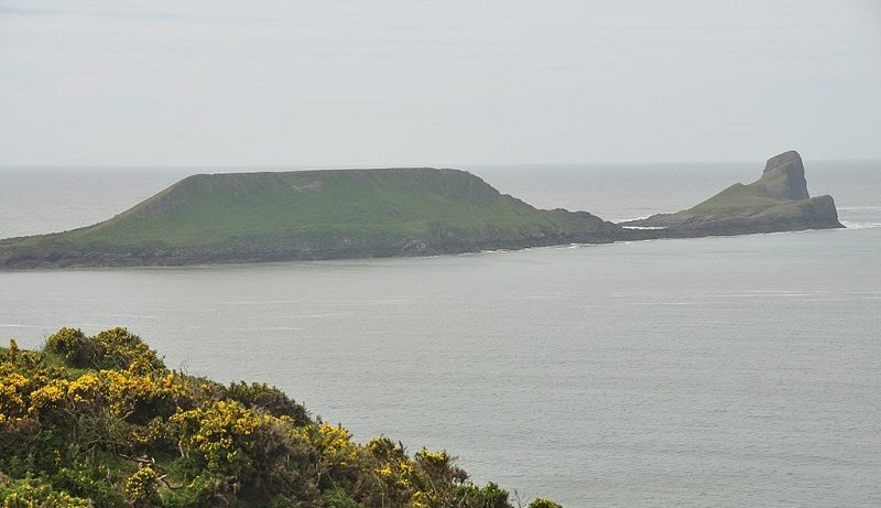
Rhossili Headland and Worms Head
Situated on the south-western tip of the Gower peninsula, this walk passes some of southern Wales’s most striking scenery, with great views of the surrounding landscape.
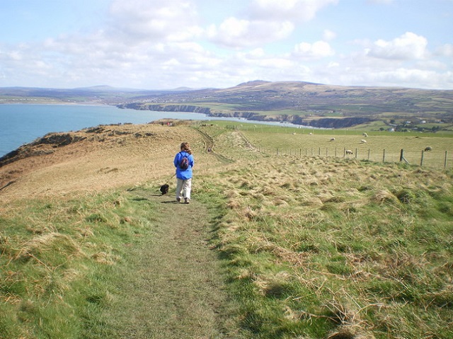
The walk starts at Worms Head car park, located just to the west of the village of Rhossili – the gravel-paved path winds its way towards the west. As you walk along the path, Rhossili Bay can be clearly seen, sweeping out to the north. The bay is backed by the great slopes of Rhossili Down, with its dark purple patches of heather. The sand dunes of Llangennith Burrows lay out to the distance, marking the northerly edge.
Walking westwards along Rhossili Headland, the path passes fairly close to the cliff edge, with the rocky crags of the clifftops easily visible from the trail. As one moves further away from the village of Rhossili, the area feels increasingly tranquil. Up ahead of you, Worms Head slowly becomes closer – located just to the west of Rhossili Headland, this is a tidal island which is cut off from the mainland twice every day. Its name derives from its appearance – of a large worm’s body ducking in and out of the water, rearing its head at the furthest point from the mainland.
The walk reaches its most westerly extent at the Old Coastguard Station. From here, a great view shows Worms Head ahead of you. If you reach this point at low tide, a great plain of rocks links the mainland with the island – allowing you to carry on down the hill, and to access Worms Head. However, if you decide to do this, it is very important that you are aware of tide times, and of the fact that the rocks are difficult to walk across.
To return to the start point, walk back on the same route.
How to find it:
The car park is located at the western end of the B4247, which links to the A4118 at Scurlage.
Co-ordinates: 51.569181, -4.289293
Length:
2.4 km/1.5 miles
Rhossili Headland and Worms Head – By CharlesC at English Wikipedia, CC BY-SA 3.0,
Stackpole Coastline and Bosherston Lakes
As expected, the southern side of the Pembrokeshire coastline contains rugged cliffs and sandy coves. However, a hidden gem exists in this area – Bosherston Lakes – a series of man-made freshwater lakes that extend inland for around 1.7 km (1.1 miles). This walk allows you to take in these lakes, as well as a beautiful part of the Pembrokeshire coast.
Starting at Stackpole Quay car park, follow the Wales Coast Path southwards. It borders the cliff edge before passing the sandy beach at Barafundle Bay – an idyllic cove flanked by cliffs on both sides. After climbing steps on the southern side of the bay, which lead you through a luscious woodland, the path yet again winds its away along the clifftops, passing rocky coves and traversing around Stackpole Head. Look out for ‘Lattice Windows’ – the name given to a series of natural arches – along this section of the walk, and the Stackpole Warren grasslands to your right.
After passing Saddle Point, another headland, the Wales Coast Path passes Broad Haven bay to the north, and reaches the outlet of the Bosherston Lakes. This walk leaves the South Wales coastal path here, and passes luscious woodland as it skirts along the southern side of the ‘Western Arm’ lake. Before crossing over a small stone bridge to the northern side, the trail passes a turning – on the left – which leads to the village of Bosherston, which contains amenities such as pubs and toilet facilities.
After crossing the stone bridge, the route follows the northern side of the Western Arm, and soon reaches a similar stone bridge, from which great views of the green and luscious landscape can be seen across the lake. After this, you will reach a grassy bridge – don’t cross this, but instead, turn left, and follow the Eastern Arm footpath until you reach a stone bridge named ‘Eight Arm Bridge’. This bridge provides further great views of the lake, which stretches out towards the north and south. Cross this bridge, and follow the track through the Deer Park, which takes you back towards Stackpole Quay car park.
How to find it:
Stackpole Quay car park is located in the small coastal village of the same name. It is accessible, via several small country lanes, from the B4319. Co-ordinates: 51.625104, -4.903891
Alternatively, parking is also available in the village of Bosherston, which is also accessible, via a country lane, from the B4319. Co-ordinates: 51.615634, -4.938098
Length of this Coastal:
9.6 km/6 miles
Barafundle Bay – By Pauline Eccles, CC BY-SA 2.0
Bosherston Lake – By Philip Halling, CC BY-SA 2.0
Glamorgan Coast – Llantwit Major Beach to Nash Point
Following a 3.8 km (2.4 mile) long section of the Glamorgan coastline, this path passes cliff tops and wooded valleys, bringing you to Nash Point headland. This walk provides great views of the cliffs on both the east and the west, and across the Bristol Channel to the south.
Starting at Llantwit Major car park, the trail runs along the Wales Coast Path to the west, climbing up onto the hill which borders the valley. The path borders the clifftops, curving around the small and sheltered Dimhole Cove, before diving into a small valley at Tresilian Bay. Flanked by striking cliffs on either side, which consist of amazing horizontal rock folds, the pebble beach is definitely worth venturing out on to.
The trail continues to follow the Wales Coast Path, closely hugging the cliff tops for 1.1 km (0.7 miles), until it descends into another valley at St. Donat’s Bay. A well-hidden part of the South Welsh coast, this tranquil bay is backed by a castle-shaped building that makes up Atlantic college, designed to imitate the 12th Century St. Donat’s Castle, located to the north of here. Following the Wales Coast Path furthermore to the west takes you up onto the clifftops yet again.
After walking for about 1.3 km (0.8 miles), you will reach Nash Point Lighthouse, a tall and white structure, and Nash Point Low Lighthouse, located around 300 metres (984 feet) to the west. This is Nash Point headland – the westerly point of this trail, which provides walkers with spectacular views to the south and the west. You may like to extend the walk slightly by walking down to the pebble beach, located just to the west of Nash Point car park. The route back to Llantwit Major car park follows the same route that brought you here.
How to find it:
Llantwit Major beach is located to the south of the town of the same name – directions are signposted from the B4265, which bypasses the town to the north. Co-ordinates: 51.396784, -3.500701
Length: 7.5 km/4.7 miles
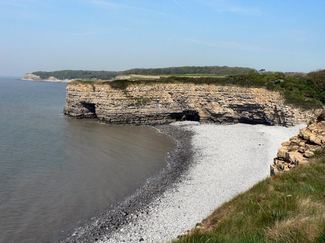
Cliffs at Tresillian Bay, Llantwit Major – By Mick Lobb, CC BY-SA 2.0,
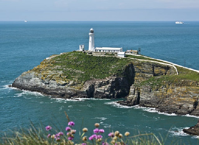
South and North Stack, Holyhead
Located on the most westerly tip of the Welsh island of Holyhead, this walk covers some spectacular scenery, with towering cliffs, a rugged island and a hill punctuated by many rugged rocky outcrops.
The walk begins at South Stack car park, from which the path closely hugs the clifftops to the north-west, closely following a small country lane that ends at a lookout point. With its grey rocky outcrops, great view of the Irish Sea, and the South Stack lighthouse to the right, this is a spectacular landscape to visit. The trail goes through a small, white archway, and follows an impressive route of steps that zig-zag down to the lighthouse from here – since the white-painted lighthouse is on a separate rocky island, a small footbridge allows access.
The trail takes you back onto the mainland and up the zig-zag steps, before turning left onto the Wales Coast Path, following it in a north-easterly direction. The trail passes some rather amazing and wild scenery, with large cliffs and crashing waves to the left, and across open moorland. Holyhead Mountain lies ahead of you. After walking for around 1.7 km (1.1 miles), you will pass to the north of its 220-metre (721-foot) peak, before following the Wales Coast path to the north, until you reach the end of the North Stack headland.
The route back to the starting point involves following the Wales Coast Path back, past Holyhead Mountain; however, when the path passes to the right of a radio mast, in order to return to the coastline, ignore this and carry on straight ahead. Walk through open moorland for about 700 metres (0.4 miles), after which you will return to South Stack car park.
How to find it:
South Stack car park is located at the end of South Stack Road, a country lane that links the headland to the town of Holyhead. The A55 North Wales Expressway terminates at Holyhead. Co-ordinates: 53.304976, -4.690373
Length:
7.2 km/4.5 miles
Bert Kaufmann from Roermond, Netherlands, CC BY-SA 2.0
https://creativecommons.org/licenses/by-sa/2.0>, via Wikimedia Commons
Great Orme Headland, Conwy
Bordering the North Wales coastal resort town of Llandudno, the Great Orme is a beautiful 207 metre (679 foot) high limestone headland. It is a popular tourist attraction, not only for its impressive cable car that links the top of the headland with Llandudno, but also for its great views of the Irish Sea, Snowdonia and the surrounding area.
Due to the presence of many tracks and paths, which traverse not only across the Great Orme, but also in a circular path around the headland, it is difficult to suggest a single set route. I am going to leave it to you to set your own walk around this spectacular part of North Wales – use Ordnance Survey map OL17 for guidance.
There are several car parks on the headland; each car park has great links to local footpaths, one of which starts and finishes at the Great Orme Summit car park, and encircles the top of the headland. On the south-western side of the summit, you can see spectacular views across Conwy Bay, with the giant peaks of Snowdonia to the south, and the rugged coast of Anglesey to the west. The northern side provides walkers with great open views across the Irish Sea.
The island itself is also rather scenic, with a myriad of jagged limestone rock outcrops facing the sea. These can be best viewed from Marine Drive, a country lane that encircles the island. Although this can be driven on, it also forms a part of the Wales Coast Path, providing another possible walk around the island.
How to find it:
Great Orme Summit Car Park is located close to the summit of the headland, at the end of Bishop’s Quarry Road. This can be accessed via central Llandudno, which is linked to the A55 North Wales Expressway via the A546. Co-ordinates: 53.332425, -3.855273
Other car parks are located on the northern side of the headland, just off of Marine Drive. This is a toll road that starts in Llandudno, and encircles most of the Great Orme in an anti-clockwise direction.
The Great Orme – By George Tod, CC BY-SA 2.0
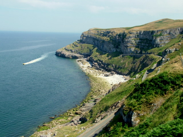
Mynydd Mawr, Llyn Peninsula
Located at the western tip of the Llyn Peninsula, Mynydd Mawr is a hill that offers great views of the Irish Sea. Located within a rather remote and unspoilt part of the coastline, this is a walk that is far from the beaten track.
The walk starts at a parking area located on a small country lane at the bottom of the hill, just after the entrance to Mynydd Mawr Caravan Site. From the parking area, follow the path in a south-westerly direction towards the sea – after about 300 metres, you will reach the Wales Coast Path, and turn right. From here, the trail starts to climb Mynydd Mawr – it clings closely to the hillside, skirting around limestone crags. With the Irish Sea spread out in all directions, and Bardsey Island out the south, the landscape has a rather peaceful feel to it.
After turning to the right, the Wales Coast Path finishes its ascent up Mynydd Mawr, climbing up some unexpected concrete steps, up onto the hilltop. The view is rather spectacular, with the fields of the Llyn Peninsula laid out below, and the brown hills of the surrounding area in full view. The peaks of Snowdonia are visible to the north-west, in the distance. A small patch of concrete lies on top of Mynydd Mawr, all that remains of a once-functioning signal station. However, this does not ruin the landscape by any means, but instead compliments it, adding a bit of history to the walk. From here, the walk leaves the Wales Coast Path, instead following a small concrete path down the hillslope, which slowly zig-zags it way back to the parking area.
How to find it:
The parking area is located at the western end of a few country lanes that connect to the B4413 just to the north of Aberdaron. Co-ordinates: 52.796246, -4.757603
Length:
1.7 km/1.1 miles
Mynydd Mawr from Trum y Ddysgl – By Gabby77, Public domain, via Wikimedia Commons
Llanddwyn Bay and Island, Newborough, Anglesey
Located on the southern side of Anglesey, this tranquil bay is overlooked by the tall pine trees of Newborough Forest. With its sandy Blue Flag beach, and a rocky island on the western side, this is an ideal beach to visit for a quiet trek onto a serene tidal island.
Starting at Newborough Warren car park, the trail climbs over the dunes onto the beach, where it meets the Wales Coast Path. The grey peaks of the Llyn Peninsula are visible in the distance, and the rocks of Llanddwyn Island stretch out into the sea on your right, with the lighthouse visible at the end. Follow the Wales Coast Path to your right, which takes you over the sandy beach, alongside the row of sand dunes.
After around 1.2 km (0.7 miles) of walking, the bay reaches a rocky outcrop opposite Llanddwyn Island. Be aware that the island is cut off from the mainland during high tide, so check local tide times before deciding whether to venture onto it. If you proceed, look out for the church ruins, a series of small white-painted cottages, and two crosses – one that has a traditional Celtic design, and one which is plain. The white lighthouse sits at the end of the island.
After visiting the island, start walking back to the car park the way that you came – however, a path leaves the beach after about 300 metres (330 yards). Follow this path, which takes you through a small section of the pine forest, to another route of the Wales Coast Path. When you reach this, turn right to return to the car park. This alternative route takes you through the pine trees, adding another layer of serenity to an already peaceful walk. After following this route for about 1.2 km (0.7 miles), you will reach the place where you started.
How to find it:
The car park is located close to Llanddwyn Beach, in the southern part of Newborough Forest. There is a £3 entry fee into the forest, which is located to the south of the village of Newborough. The A4080 links Newborough with the A55 North Wales Expressway. Co-ordinates: 53.144315, -4.385243
Length:
6 km/3.7 miles
Llanddwyn Bay from Llanddwyn Island – By The original uploader was Nabokov at English Wikipedia. – Transferred from en.wikipedia to Commons by Wouterhagens using CommonsHelper., CC BY-SA 3.0,
Dinas Island, Pembrokeshire
Whilst not strictly an island in the true sense, Dinas Island is a large headland that reaches from the mainland into Cardigan Bay. With a 142 metre (465 foot) high summit that boasts spectacular views of the western Wales coast in both directions, and of the rolling Pembrokeshire hills to the south, this is a landscape that is well worth a visit.
The walk starts at the car park bordering Pwllgwaelod Cove, a small and sheltered cove to the south-west of the headland. Follow the Wales Coast Path to the north, which winds up along the clifftops along the western side of the headland. With great views overlooking Fishguard Bay to the west, and the cliffs winding along the side of the bay, this is a beautiful viewpoint along the trail. The path continues to climb, with the cliffs to the left, and fields to the right.
After walking for about 1.8 km (1.1 miles), the path reaches the summit on the north of the headland. The long climb is well worth it for the great 360° views of the surrounding area. The route continues arching around the northern and eastern sides of the headland, while slowly descending into the small traditional seaside village of Cwm-yr-Eglwys. To walk back to Pwllgwaelod Cove, follow the footpath along the valley which divides Dinas Island from the rest of the mainland. It is located to the right of a yard where small boats are stored. After walking for 0.9 km (0.6 miles), you will return to the car park.
How to find it:
Pwllgwaelod Cove car park is located at the end of a country lane that turns off of the A487 at the village of Dinas Cross. Co-ordinates: 52.021348, -4.908131
Length:
5 km/3 miles
Dinas Head, Looking to the West – By Richard Law, CC BY-SA 2.0
Coastal Point of Ayr, Flintshire
The northernmost point of the Welsh mainland, the Point of Ayr marks the point where the River Dee estuary meets the Irish Sea. With a great expanse of golden sand backed by a large expanse of sand dunes named The Warren, this is worth visiting if you like lovely beaches and are not a huge fan of climbing up hills.
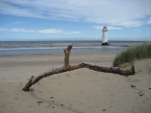
The walk starts at Talacre Beach car park, and follows the Wales Coast Path to the north, onto the beach. Turn left and follow the path along the beach, following the sand dunes. The Point of Ayr lighthouse lies out to sea – accessible at low tide (but not open to visitors), the lighthouse is helpful in preventing boats from beaching on the sand flats that reach out to sea during low tide.
After walking along the beach for around 2 km (1.2 miles), a footpath branches off to the left, taking you away from the beach and through the sand dunes. After another 400 metres (440 yards) of walking, you will reach a holiday caravan park – a paved track, which turns off from the path to your left, will take you back to Talacre Beach car park. The route passes the dunes to the left, and through a lovely grass area mixed in with bushes and small patches of woodland. After this, you will reach the starting point.
How to find it :
Talacre Beach car park is located at the end of Station Road, which links the village of Talacre with the A548. Co-ordinates: 53.352543, -3.317145
Length:
4 km/2.5 miles
Talacre Beach – Point of Ayr Lighthouse – By Day Barr from Cambridge – lighthouse, CC BY-SA 2.0,
Cover photo: Worm’s Head by Nilfanion, CC BY-SA 4.0, via Wikimedia Commons