
Surrounded by giant mountains, craggy hills, extensive coastal lochs (or fjords), and vast peninsulas, this section of coastline runs along the western limit of the Scottish Highlands. Along with the entire stretch of coastline that borders the Scottish Highlands, this is arguably the most extreme coastal landscape seen in the British Isles. Two broad sections of the coast are described here – the stretch between the Kyle of Lochalsh and the Rubha An Ridire headland, as well as Loch Linnhe. The coastline also sits opposite several large Inner Hebridean islands, and numerous smaller islands.
Kyle of Lochalsh to Rubha An Ridire
The coastline borders both the sea and the fjords along this stretch. Steep mountain slopes dominate the landscape, with their impressive rugged crags visible from the shoreline. Several large fjords exist along the coastline; these are a result of glacial carving due to the many Ice Ages which have occurred during the past 2.4 million years, and the distinctive U-shape of the loch valleys is a result of this process. Loch Duich, Loch Hourn and Loch Nevis are three examples of this type of extreme terrain.
Loch Hourn is bordered by the giant Beinn Sgritheall mountain on its northern side, and the towering 1,020 metre (3,346 foot) Ladhar Bheinn just to its south – both these peaks are a great example of an incredibly spectacular landscape that is seen along much of this coastline. Although Loch Duich is also flanked by giant peaks reaching up to 800 metres (2,600 feet) in height, unlike Loch Hourn, conifer forests grow on the sides of the fjord, creating an almost fairy-tale feel to the landscape.
The large mountain-covered peninsulas of Knoydart and Ardnamurchan stretch out dramatically into the sea. Knoydart is bordered by Loch Hourn and Loch Nevis on either side, and the lack of road access means that the bay can only be accessed by boat or by hiking. The sea-facing (western) side contains many rock crags, headlands and even a few coves. For example, Sandaig Bay contains a small patch of white-yellow sand surrounded by black-grey rocks [1]. Inverie Bay, located on the Loch Nevis (southern) side is larger than a cove – it contains a patch of sandy beach on its eastern side, and steep rugged sides on its western end. With 120 inhabitants, the tiny village of Inverie lies on the shore of this bay, with the steep forested slopes rising behind it [2].
The Ardnamurchan peninsula, located 45 km (28 miles) to the south-west of Knoydart, also has a rather remote feel to it – access is only possible by a single-track road. The peninsula contains many rugged rock flats interspersed with numerous small coves – in particular Fascadale Bay, Sanna Bay and Kilchoan Bay [3]. Sanna Bay is a rather stunning bay within a beautiful landscape – an extensive arc of white sand is bordered by an area of sand dunes, with the rocky Sanna Point headland jutting out into the sea just to the north. On the peninsula’s far south-eastern edge, surrounding the village of Glenborrodale, luscious oak woodlands stretch along the rugged coastline [4].
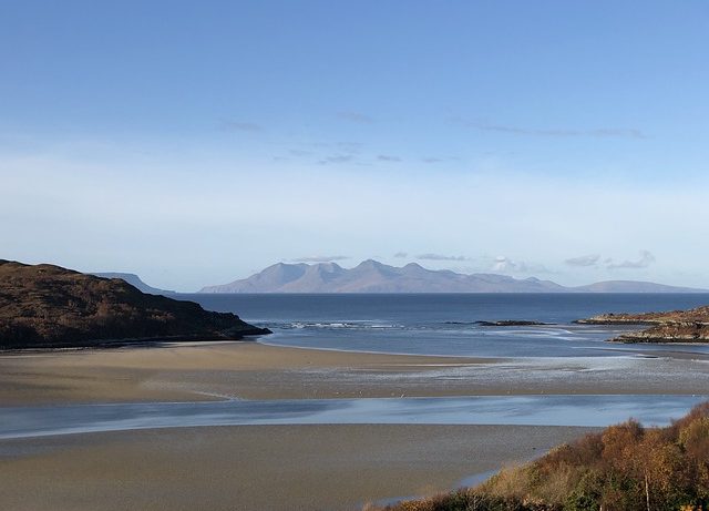
Numerous villages line this portion of the coastline, each with their own local attractions and features. The working fishing port of Mallaig is nestled beneath steep and rugged hills, from which ferries sail to several of the Inner Hebridean islands [5]. 4 km (2.5. miles) to the south, the village of Mòrar sits above a beautiful sandy bay known as the Silver Sands of Mòrar, from which beautiful views of some of the Hebridean islands can be seen [6]. The beautiful freshwater Loch Mòrar stretches eastwards from behind the village, connected by the River Mòrar that flows over a series of low waterfalls into the sea. Although other villages and hamlets exist along the coastline, the pretty village of Arisaig is renowned for its white-painted cottages overlooking the beautiful Loch nan Creall bay, which is nestled between the rugged hilly landscape.
Loch Linnhe
With a fantastic scenery, the 50 km (30 miles) long Loch Linnhe extends north-westwards from the sea into the Scottish interior. Flanked by huge and rugged mountains on both sides, the fjord attracts tourists from far and wide due to its picture postcard, and quintessentially Scottish, mountain landscape. The coast is also bordered by extensive forests, a few villages, and a couple of small port towns. Several islands are located towards the mouth of Loch Linnhe – the largest of these being the Isle of Lismore.
Of the many peaks on the north-western side, Creach Bheinn is perhaps the most notable – with an elevation of 853 metres (2,798 feet), not only is this the tallest mountain on this side of Loch Linnhe, but incredible views of the fjord can be seen from the top. Like many of the mountains here, the upper slopes are characterised by near-vertical crags, whereas the lower slopes tend to be less steep in places – a result of the glacial carving of these mountains during previous Ice Ages [7]. Also, the large Beinn a’Bheithir mountain ridge, located on the south-eastern side of the fjord, offers great views of both Loch Linnhe and the smaller Loch Leven which feeds into the former loch [8].
A number of settlements straddle the edges of the loch, albeit mainly on the south-eastern side. The village of Caol and the small town of Fort William are located at the head of Loch Linnhe; the former provides incredible views of Loch Linnhe straight ahead, with the smaller Loch Eil to the west and the 1,344 metre (4,409 foot) high Ben Nevis – Britain’s tallest mountain – to the east. Sand flats also extend from Caol down to Fort William – since this is the head of the loch, the water depth is rather low compared with its more southerly stretches. Nestled between the loch and the mountains, Fort William is a quiet town that boasts attractions such as the West Highland Museum, which includes exhibits about the 1745 Jacobite rising, as well as numerous pubs, restaurants and hotels [9]. Located at the mouth of the loch, the more traditional town of Oban contains a selection of attractions, including the Oban whisky distillery, McCaig’s Tower (a large circular stone monument), and a picturesque promenade, from which views across Oban Bay towards Kerrera Island can be seen [10].
References
[1] http://www.glenelgscotland.com/sandaig.htm
[2] https://www.visitknoydart.co.uk/about
[3] https://www.visitscotland.com/info/towns-villages/ardnamurchan-area-p236481
[4] https://www.rspb.org.uk/reserves-and-events/reserves-a-z/glenborrodale/
[5] https://www.visitscotland.com/info/towns-villages/mallaig-p236601
[6] https://www.visitscotland.com/info/towns-villages/silver-sands-of-morar-p315041
[7] https://www.walkhighlands.co.uk/corbetts/creach-bheinn-loch-creran
[8] https://www.walkhighlands.co.uk/munros/sgorr-dhearg-beinn-a-bheithir
[9] https://www.visitscotland.com/info/towns-villages/fort-william-p236531
[10] https://www.visitscotland.com/destinations-maps/oban/
Image: Morar by Tina Koehler on Pixabay