
This article covers a stretch of coastline in South Wales, starting at the River Neath just to the east of the port town of Swansea, and carrying on around the Gower peninsula and Carmarthenshire coastline to Telpyn Beach. This is a rather beautiful stretch of coastline, with some quite wild sections in places.
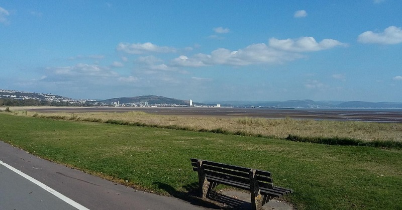
The large port town of Swansea sits on the northern coast of Swansea Bay. A large university town with industrial docklands and a modern marina with recreational facilities, Swansea is rather vilbrant. The new state-of-the-art Swansea Bay Campus sits along the low-lying coastline to the east of the town. Its large buildings are visible for many miles. At the city centre, the River Tawe divides the coastline, with mainly docks to the east, and a newly-regenerated area of Swansea known as the Maritime Quarter to the west. The latter area contains a marina, waterfront apartments, restaurants and a couple of art galleries.
To the west of the city centre, Swansea Beach stretches for 8 km (5 miles) around the western side of the bay – this sandy beach and passes several small seaside towns, including West Cross and Oystermouth [1]. The south-western extent of Swansea Bay is marked by a headland, the end of which is marked by two small rugged islands known as The Mumbles, which are accessible during low tide. A short pier juts out from the headland, not to the islands, but out into the bay. A few attractions, including restaurants and an amusement arcade, also bring tourists to the area.
The Mumbles also marks the boundary of the Gower peninsula, a 30 km (19 mile) long peninsula that stretches westwards into the Bristol Channel.
A very beautiful and tranquil place to visit, it is characterised by stunning and rugged cliffs harbouring small and sheltered coves, interspersed with sandy beaches and small seaside villages [2]. Langland Bay, Caswell Bay and Oxwich Bay are among three sandy beaches that are located along the southern coast of the peninsula. Whereas Oxwich Bay is more remote and wild, with its rural setting and sand dunes, Langland Bay is bordered by the seaside village of the same name, and contains many picturesque Victorian-era buildings.
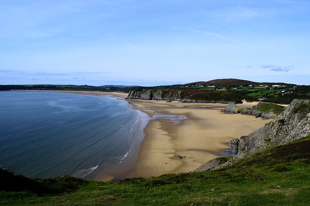
However, the most stunning beach on Gower has to be Rhossili Bay. Located on the western side of the peninsula, this 4.5 km (2.8 mile) long sandy beach is backed by a towering hill named Rhossili Down, which rises steeply from the shoreline. The bay is bordered to the south by Rhossili Point, a large headland that stretches out into the Bristol Channel. This is popular with tourists for its stunning 360-degree views across Rhossili Bay to the north, Carmarthen Bay to the north-west, and the Bristol Channel to the south, as well as the hills of the Gower to the east. Furthermore, a narrow and rugged island known as Worms Head sits at the end of the headland, and can be accessed during low tide. As well as quaint cottages, the small village of Rhossili also includes a pub and a restaurant.
Rhosilli Bay Gower – Source: Youtube Dave Bevan
With its incredibly rugged coastline, prominent cliffs with headlands are a rather common Gower feature, particularly on the southern side of the island. These include Pwlldu Head, Oxwich Point and Port Eynon Point. However, the cliffs are not near-vertical rockfaces, such as those seen in North Devon or along the Glamorgan Coast, but are much more rugged in their appearance. For example, at Port Eynon Point, the base of the cliffs is dominated by many rugged rock formations, which are made more visible at times of low tide. The neighbouring village of Port Eynon contains quaint buildings, including cottages, small hotels and pubs.
Not all of the peninsula is characterised by cliffs. The northern edge tends to be much more low-lying, and apart from a small area of sand dunes known as Whiteford Burrows, much of northern Gower is bordered by the extensive Llanrhidian Marsh. This side of the peninsula borders the River Loughor, a tidal estuary that is comprised almost wholly by mudflats, which are exposed during low tide.
The head of the Loughor estuary, close to the town of the same name, marks the eastern limit of the northern side of the Gower peninsula, as well as the border between The Gower and Swansea, and the county of Carmarthenshire. Moving westwards along the northern side of the Loughor estuary, an extensive area of lakes, streams and lagoons borders the coastline. Recognised as a nature reserve, and named Llanelli Wetland Centre, this large range of habitats acts as a refuge for many different plants and animals, including tens of thousands of migratory birds every year [3].
Heading eastwards, past the port towns of Llanelli and Burry Port, the Loughor estuary meets Carmarthen Bay. This vast bay is bordered by large sand dune systems to its north and east, the mouths of two large estuarine channels (including the Loughor), and rugged cliffs along the western half. One of these sand dune systems, Pembrey Burrows, extends between the town of Burry Port in the east and Tywyn Point in the west.
The dune system is being continuously added to by wind-blown sand deposits, blown in from the extensive sandy beach that lines the coast here. The older and more stable dunes have been colonised by grasses and a wide range of plant species, some of which are rather rare [4]. Behind the dunes, a large pine woodland is used for recreational activities, including hiking, cycling and orienteering.
The western extent of Pembrey Sands is limited by the large Towy estuary, which itself is fed by three rivers. The wide estuary reveals a vast expanse of sand flats at low tide. Another row of sand dunes – Pendine Burrows – which is located to the west of the large estuary, is used by the Ministry of Defence for target practice.
For the most westerly 4km (3 miles) of the Carmarthenshire coastline, the landscape changes abruptly from sand dunes to a series of cliffs, as well as a hill called Marros Beacon. Unlike Pendine Burrows, public footpaths wind their way along the hillside, from which views across Carmarthen Bay can be seen. Telpyn Point, a small headland to the west of the hillside, marks the county boundary between Carmarthenshire and Pembrokeshire. This means that the western part of the Carmarthen Bay coastline is not actually in Carmarthenshire, but in the neighbouring county, and is covered in the Pembrokeshire coast article.
References
[2] https://www.visitswanseabay.com/destinations/gower-peninsula/
[3] https://www.wwt.org.uk/wetland-centres/llanelli/wildlife/nature-reserve/