
This article describes the stretch of coastline that borders the eastern side of two English counties: County Durham and Tyne & Wear. This coastal stretch begins at the River Tees in the south and ends just north of the town of Whitley Bay, bordering the North Sea and encountering two main rivers: the River Wear and the River Tyne.
The southern end of the County Durham coastline begins at the mouth of the River Tees. Here, a marshy nature reserve forms a barrier between the sandy beach and the industrial landscape behind. Despite the high level of industrial activity in this area, the coast still maintains a sense of tranquillity – the nearby seaside town of Seaton Carew offers a clean and sandy beach, a promenade, and various cafes and restaurants, all of which make this town a decent destination for day trippers. However, Seaton Carew contrasts quite starkly with the town of Hartlepool, which is located 3km (2 miles) to the north.
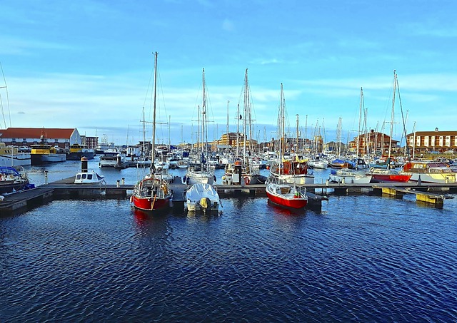
This port town consists of large docks that are a relic of the town’s once heavily industrialised heritage. Although a few light industrial warehouses exist today, this is nothing compared to what the port town once was – a bustling heavily industrial port town. Industrial decline is a familiar occurrence in the North East of England, and Hartlepool has undergone a large regeneration since, with the development of tourist attractions including an art gallery, a historic quay and a marina that is used for recreational use [1]. Another tourist attraction is the HMS Trincomalee – this is Britain’s oldest intact and afloat warship, and it is located in the marina [2].
Moving north-westwards up the coastline, a large expanse of sand known as Crimdon Dene Beach stretches between Hartlepool and the village of Blackhall Rocks. Backed by sand dunes, the beach feels rather remote – it is not close to a seaside town, although new houses are being built on the outskirts of Hartlepool close to the beach. Another relic of the industrial past, the disused Steetley Pier stretches out for around half a kilometre (around 550 yards) into the North Sea. This was never a pleasure pier, however – it was once used to transport seawater required for a heavy industrial plant that once existed on the coastline. No trace of this plant remains today, apart from this disused pier [3].
North of Blackhall Rocks, the coastline becomes more dramatic, with low but rugged cliffs dividing the rocky beach from fields and towns inland. Travelling northwards along the Durham Heritage Coast, one encounters gentle headlands and small bays, such as Chourdon Point and Shippersea Bay, while a functional coastal railway runs on top of the cliffs. The cliffs are interrupted by the port town of Seaham – with a harbour that is used as a marina, and a choice of cafes and restaurants, this is a rather laidback town that is ideal for day visitors [4].
North of Seaham, the coastline leaves County Durham and enters Tyne & Wear. It once again reverts back to its rugged cliffs, with several small bays and headlands, until it reaches the large port town of Sunderland. Light industrial units line the large docks, that are located to the south of the River Wear that flows into the North Sea. North of the river, the coastline is far more attractive to residents and tourists – a regeneration project has resulted in the construction of a marina, and the coast along the north Sunderland coastal suburb of Roker includes a promenade, a long pier with a lighthouse at the end, and several cafes. Roker is a rather laidback resort town, as is the town of Saltburn just to the north, which contains numerous restaurants, and a wide and extensive beach.
Once again, the coast continues northwards, passing the villages of Whitburn and Marsden. The mostly shingle beach here is incredibly rugged – as the tide goes out, many rocks and rockpools are exposed. Other notable geological features also exist here, such as the Souter Hole sinkhole. Despite being a rather small feature, this sinkhole is notable, as its likely causation is due to the collapse of disused coal mines – this area was once a key coal mining area. It is closed to the public, with warning signs ordering people to stay away.
The cliffs terminate at the town of South Shields. Divided from its sister town – North Shields – by the mouth of the River Tyne, South Shields is renowned for being a local tourist destination, with attractions such as Sandhaven Beach and a large pleasure park called ‘Ocean Beach’, which includes fun fair rides, an amusement arcade, cafes and restaurants. North of the River Tyne, the once-bustling port town of North Shields still holds onto pockets of light industry. However, the town has historical features associated with it, including Clifford’s Fort – a battery built in 1672 to defend the ports along the River Tyne, including Newcastle-upon-Tyne and North and South Shields, from potential invading armies [5]. Also, the ruins of Tynemouth Priory and Castle are located on a headland just to the north of where the Tyne and the North Sea meet; with the Priory being built in 1090, and the castle probably being built at the same time (although this is uncertain), this is a significant historical landmark for much of the north-east of England [6].
Passing the rugged landscape at King Edward’s Bay, the coastline levels out at Tynemouth Longsands, an expanse of sandy beach that stretches around 1km (1000 yards) in length. Moving further northwards, the coastline passes the lovely Cullercoats Bay, with its small harbour and scenic Victorian buildings, and carries on to the seaside town of Whitley Bay. Another picturesque British seaside resort town, with an extensive promenade and a long, sandy beach, Whitley Bay contains the newly refurbished Spanish City – an Edwardian building which is known for its large dome and renaissance-style architecture. Today, it contains various restaurants which offer a range of different food options, including traditional fish and chips, afternoon tea, and fine dining [7].
The beach alongside Whitley Bay continues for around 2km (1.2 miles) northwards, terminating at a headland. At the end of the headland sits a small island around 100m (100 yards) from the coast, upon which sits Saint Mary’s Lighthouse and a couple of other buildings. The island is accessible at low tide, with a causeway linking the island with the mainland. The border between Tyne and Wear and the county of Northumberland is located just to the north of here – as with many British counties, there is no physical boundary that divides them.
Reference
[1] http://www.thisishartlepool.co.uk/attractions
[2] http://www.thisishartlepool.co.uk/attractions/trincomalee.asp
[3] https://www.steveniceton.co.uk/steetley-pier/
[4] https://www.thisisdurham.com/explore-durham/durham-towns/seaham
[5] http://www.castlesfortsbattles.co.uk/north_east/cliffords_fort_tynemouth.html
[6] http://www.castlesfortsbattles.co.uk/north_east/tynemouth_castle.html
[7] https://spanishcity.co.uk/
Image Source Hartlepool Marina: TreborReknub01 on Pixabay