
Stretching along the rugged coastline of western Scotland, this coast borders beautiful bays and large lochs, surrounded by rugged hills and mountain peaks, open coastal moorland and sprawling forests. Small fishing villages border the shoreline here, and islands of various shapes and sizes lie out to sea, adding to the scenic landscape within this part of Scotland.
Oban to Mull of Kintyre
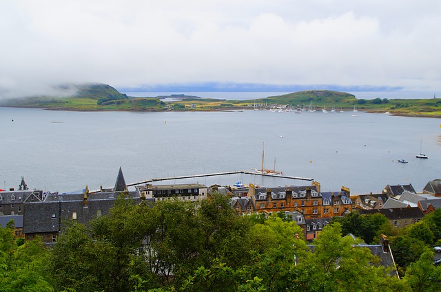
This coastal section runs southwards from Oban, past several large Inner Hebridean islands. Numerous lochs stretch inland from the sea; although they are not as wide and extensive as the vast fords to the north, and instead consist of relatively small rocky inlets and bays, they are just as impressive. Also, this coastal stretch is bordered by rugged hills rather than towering Scottish Highlands, but nevertheless, they still produce some rather spectacular landscapes. Numerous islands also lie out to sea – whereas some of these are small rocky crags, others are rather large in size, such as Luing, Shuna and Jura.
Of the many lochs along the coastline, Loch Craignish is particularly renowned for its beautiful landscape. With several islands located in the centre of the small fjord, extensive conifer forests on its eastern side, and a rocky headland named Craignish Point (located to the west of the loch’s mouth), Loch Craignish is a nice place for tourists to visit [1]. Like much of the coastline around here, the islands within the loch, as well as the loch itself, are shaped in a distinctive south-south-west to north-north-east direction – this is due to the movement of large ice sheets, which formed during numerous Ice Ages over the past 2.4 million years, shaping these landforms. The same formation can be seen at Loch Sween to the south, as well as the incredible craggy and forested landscape that surrounds the loch. Also, the scenic Loch Melfort is surrounded by craggy hills on either side, whereas the forest-lined West Loch Tarbert almost divides the Mull peninsula in two.
As mentioned, the coastline is generally bordered by steep and rocky hills which are often under 400 metres (1,300 feet) in height. Although they are covered in moorland, extensive forests also line the coastline, adding to the wild feel of the landscape. South of Machrihanish Bay, itself a rare example of a sandy beach and dunes along the Kintyre peninsula, the coastline is incredibly rugged, with steep 300 metre (1,000 foot) high hillslopes sliding down to the pebbly shoreline. Several small headlands are located along the coast. At the southern tip of the peninsula, named the Mull of Kintyre, great views of Ireland can be seen across the Straits of Moyle, a relatively narrow gap that marks the boundary of the Irish Sea to the south-east and the Atlantic Ocean to the west. With its small solitary white-painted lighthouse amongst the vast hills, the Mull of Kintyre landscape feels incredibly tranquil and remote, with almost an ‘end of the world’ feel to the landscape [2].
Mull of Kintyre to Dumbarton
The coastline between the Mull of Kintyre and the coastal town of Dumbarton borders the eastern side of the Kintyre peninsula, around the vast Loch Fyne, and twists around several other lochs, and along the northern side of the Clyde estuary.
Moving northwards from the Mull of Kintyre, the coastline passes a wide variety of coastal scenery, from the small and sandy Carskey and Dunaverty bays, to steep hillsides and craggy cliffs with headlands and rocky shorelines. Campbeltown is located at the head of a small bay; it is a traditional, quiet Scottish grey-stone town, the largest on the Kintyre peninsula [3]. Continuing northwards, the coast passes through a beautiful and tranquil landscape, with intermittent conifer forests flowing down from the hilltops to the rocky shoreline. The coast twists around rugged headlands that are interspersed with small bays and coves, such as Torrisdale Bay.
North of Skipness Point, the coastline starts to border Loch Fyne. Extending 65 km (40 miles) inland, Loch Fyne is the longest of the Scottish lochs. The coastal landscape on both sides of the loch is rather similar to that of the Kintyre peninsula and around Loch Craignish. With tranquil spruce and fir forests dominating the hilly landscapes, and numerous small bays dotted along the shoreline, the landscape is truly remarkable. The occasional small town or village sits on the shore, including the idyllic village of Tarbert, with its harbour lined with beautiful townhouses [4], and Inveraray, a traditional Scottish town consisting of white-painted buildings. One of Scotland’s iconic buildings, Inveraray Castle, also overlooks the loch [5].
The headland of Ardlamont Point is located on the eastern side of the mouth of Loch Fyne. To the west, the coastline travels around the Cowal peninsula, with the Kyles of Bute sea channel separating the mainland from the Isle of Bute. Like the coastline around Loch Fyne, this is also bordered by vast forests, although patches of moorland are also visible. The coast passes the village of Tighnabruaich, a small and tranquil village penned in between the shoreline and woodland [6], and winds its way around the steep slopes of Loch Riddon and Loch Striven, both of which protrude northwards. At Toward Point, the Kyles of Bute meets the mouth of the Firth of Clyde, which leads to the large city of Glasgow.
The port town of Dunoon is located 10 km (6 miles) to the north of Toward Point – with its large Victorian pier and bustling promenade, and numerous bed-and-breakfast hotels, pubs and restaurants which overlook the pebbly East Bay [7]. North of Dunoon, Loch Long extends northwards from the Firth of Clyde. It is flanked by towering craggy peaks, as well as smaller loch inlets, on its western side. The loch is also lined with coniferous forest along much of its steep western side, forming part of Argyll Forest Park. Small streams also run down from the peaks into the loch. Despite the wild nature of the land bordering western and northern sections of Loch Long, parts of the eastern side have a more industrial usage, in the form of a large Royal Naval Armaments Depot located close to the village of Coulport.
West of the mouth of Loch Long, the coastline wriggles around Gare Loch, and then reaches the coastal town of Helensburgh. An idyllic Victorian-era seaside resort, Helensburgh is famous for both its long promenade and its pier, both of which provide scenic views across the Firth of Clyde. Moving westwards from here, the shoreline consists of long sandy beaches as the Firth of Clyde narrows and becomes the Clyde estuary [8]. The coastline is bordered by rather gently sloping land as it carries on to the town of Dumbarton. Dumbarton Rock dominates the coastal landscape here – this is a large volcanic plug which infilled a volcanic crater around 350 million years ago – it sits on the edge of the Clyde estuary, its near-vertical sides inaccessible on all sides. The rock is now home to Dumbarton Castle, which overlooks both the estuary to the south, and the town of Dumbarton to the north. The Denny Tank Museum showcases the once-industrialised nature of the Clyde estuary, including Dumbarton’s shipbuilding heritage, as well as that of the docklands towards the large city of Glasgow, which exists around 21 km (13 miles) to the south-east of Dumbarton [9].
References
[1] https://www.visitscotland.com/info/towns-villages/loch-craignish-p1422351
[2] https://www.walkhighlands.co.uk/argyll/mull-of-kintyre.shtml
[3] https://www.visitscotland.com/info/towns-villages/campbeltown-p235331
[4] http://www.tarbertlochfyne.com/
[5] https://www.visitscotland.com/info/towns-villages/inveraray-p235311
[6] https://www.visitscotland.com/info/towns-villages/tighnabruaich-p234871
[7] https://www.visitscotland.com/info/towns-villages/dunoon-p234961
[8] https://www.visitscotland.com/info/towns-villages/helensburgh-p235131
[9] https://www.visitscotland.com/info/towns-villages/dumbarton-p235121