
This article covers the stretch of the South Wales coastline from the England/Wales border (near the town of Chepstow) and the River Neath estuary, which is located between the towns of Port Talbot and Swansea. The coastline includes rural areas intercepted by several towns, including the towns of Barry, Porthcawl and Port Talbot, and the port city of Cardiff.
The coastline between the border and the city of Cardiff forms the northern side of the Severn estuary, and is mainly characterised with tidal mudflats and marshlands, with the coast running alongside a mainly rural landscape that is interspersed briefly by the Second Seven Bridge and the River Usk estuary. However, part of the coastline is notable for its archaeological importance – Mesolithic-era footprints, occupation sites, Iron Age trackways and a submerged forest were discovered preserved within the mudflats close to the village of Goldcliff, which is located close to the mouth of the Usk estuary [1].
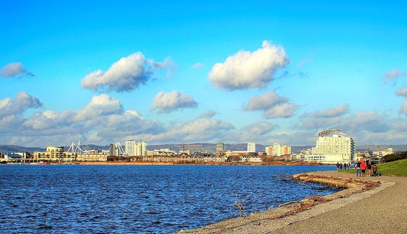
However, as the coastline nears the Welsh capital city of Cardiff, the landscape drastically changes. Although the city centre does not border directly onto the coastline, Cardiff has many docks and recreational facilities located on the Severn estuary. Storage warehouses and concrete plants border the eastern side of Cardiff Docks. However, another section of the coastline at Cardiff is very different, and is made up of tourist and recreational attractions and amenities. At the head of Cardiff Bay, which is a semi-natural harbour, the waterfront is bordered by modern apartments, office buildings and recreational facilities, which include bars, restaurants and an arts centre. The Senedd, a modern building at which the Welsh parliament is based, also overlooks Cardiff Bay [2]. Penarth Marina & Haven, a modern recreational yachting marina, is located on the other side of Cardiff Bay, close to the suburban seaside town of Penarth.
The Penarth seafront faces directly onto the Severn estuary, offering wide and expansive views. This seaside town includes a rather quaint pier, which includes a large Pavilion. The esplanade is lined with many picturesque buildings, including various hotels and cafes positioned in front of a line of cliffs. These cliffs grow in size as one travels southwards towards Lavernock Point, a headland that juts out into the sea. This promontory marks the boundary between the Severn estuary to the north and the east, and the Bristol Channel to the west.
To the west of Lavernock point, the rocky and rugged coastline winds towards the seaside town of Barry. Although the town is still clinging on to remnants of its industrial heritage, Barry has undergone a large regeneration project, with a modern waterfront lined with residential housing. There is also a beach at Barry – located on Whitmore Bay, the sandy beach includes a fun fair and several restaurants. To the west of Barry Harbour, a pebble beach dominates the seafront.
The coastline between the towns of Barry and Porthcawl is characterised by cliffs bordering the coastline, and extensive pebble beaches and rock flats that are exposed during low tide. To the west of Aberporth, the coastline is rather rural, with farmland bordering the clifftops. Several wooded valleys briefly interrupt the cliffs at various points along the coast. One of these valleys reaches the coastline at Saint Donat’s Bay, where a Medieval castle borders the sea. With features such as a moat, high walls, battlements and many dungeons, this castle is very popular with visitors [3]. An arts centre is also located adjacent to the castle.
On the clifftop, just to the west of Saint Donat’s Castle, a lighthouse stands on top of Nash Point, a promontory headland on the Bristol Channel coastline. The coastline between here and the seaside village of Ogmore-by-Sea is part of the Glamorgan Heritage Coast, where rugged and near-vertical cliffs wind around numerous bays and headlands. Incredibly distinct and visible horizontal rock layers can be seen in these cliffs – this is because several layers of various limestone types were laid down at different times between 350 and 180 million years ago. The lower limestone layer is rich in fossils, including crinoids, brachiopods and corals [4].
The view from Witches Point headland is absolutely stunning – the winding and towering cliffs of the Glamorgan Heritage Coast, on either side of the viewpoint, can be seen. A vast area of the Bristol Channel can also be viewed, and the hills and high cliffs of Exmoor are visible from here. The ruins of Dunraven Castle are located on the headland, and the wooded Dunraven Park stretches down from the castle and its walled garden to the shore [5]. Rocks on the beach are also arranged in wavy lines, which can be seen most spectacularly during low tide. This shows just how remarkable this coastline is for its natural landscape.
By the time the cliffs reach Ogmore-by-Sea, they are somewhat lower in height, and north of the River Ogmore, a sand dune system stretches around the sandy Merthyr Mawr Beach. Moving north-westwards via the seaside town of Porthcawl, with its sandy beaches and esplanade, the coastline passes an even more extensive system of sand dunes. Known as Kenfig Burrows, this is a very extensive series of sand dunes that provides a very suitable habitat for many animal and plant species, some of which are rather rare. Therefore, this site has been declared both a nature reserve and a Site of Special Scientific Interest for its biodiversity. Kenfig Burrows offers great views across Swansea Bay, where views of the seaside town of Swansea can be seen, as well as the eastern edge of the Gower peninsula [6].
However, as is common with the South Wales coastline, industry is never too far away from beauty spots. The Port Talbot Steel Works is located only 2 km (1.5. miles) to the north-west of Kenfig Burrows; the largest steel works in the United Kingdom, and one of the largest in Europe, this facility stands out significantly. The town of Port Talbot is located just to the north-west of the steelworks, after which the River Neath cuts through the coastline. This marks the end of the stretch of coastline covered in this article.
References
[1] https://www.megalithic.co.uk/article.php?sid=31093
[2] https://www.visitwales.com/destinations/south-wales/cardiff/top-things-see-and-do-cardiff-bay
[3] https://www.visitwales.com/attraction/castle/st-donats-castle-1169722
[4] https://walescoastpath.co.uk/fossils-on-the-glamorgan-heritage-coast/
[5] https://www.parksandgardens.org/places/dunraven-park
[6] https://www.visitwales.com/attraction/nature-or-wildlife/kenfig-national-nature-reserve-917595