
The First Catch
It was a wet and windy September’s day in 1931 – a few of those hardy souls that brave the angry seas were hard at work aboard the Colinda.
THE COLINDA – was a British fishing trawler, one which was about to make a groundbreaking discovery.
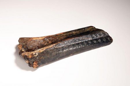
The ship was approximately 25 miles off the Norfolk coast in the region of the Leman and Ower banks. Trawlers of this type drag nets across the sea floor picking up everything that doesn’t slip through the small gaps, fish, crustaceans, plants, muck, shipwreck debris, even unexploded bombs. On this occasion the net pulled up from 120 feet had trapped a large piece of peat or moorlog. The skipper, one Pilgrim E. Lockwood, spied the snag and grabbed his trusty shovel to break it up before tossing the lot over the side. However, when he gave the object a good whack it clanged back at him, in his words it was like striking metal. Yet, it was not metal but in fact antler!
What came out of the clump of apparently worthless muck was an 8.5-inch-long prehistoric harpoon, oval in shape, curved along one edge with seventeen curved barbs. The barbed portion measuring 6.5 inches. The British Museum’s specialists examined the piece, which became known as the Colinda harpoon, and determined that it was Mesolithic. This meant that it must have belonged to hunter-gatherers between 10,000 and 4,000 BCE. This puzzled researchers because it was very unusual that such an item could end up in the murky depths of the North Sea many miles from shore. Even by todays understanding of the Mesolithic peoples of Europe, it is highly unlikely that the types of simple boat crafted would have made it to open seas. Most water activity in the Mesolithic era was strictly confined to shorelines.
The mystery of the Colinda harpoon sparked a wave of further scientific research, and the following year was another of big discoveries. Jaws hit the floor when pollen analysis of a peat core taken from the same region of the North Sea bed yielded incredible results. The chemical study told researchers that the deposit had formed in a freshwater environment not a marine one.
Whoever had lost the Colinda harpoon had done so on dry land, right where the North Sea is now. Scientists had theorized for years that the sea level in Mesolithic times was much lower than in their own given the ancient forests which protrude from the sea on tidal flats, but this new evidence revealed the factual existence of what eventually would be dubbed ‘Doggerland’. Moreover, it not only confirmed the presence of a lost land mass but one which was occupied by humans.
Widening the net …
The discovery of the Colinda harpoon and the irrefutable evidence for Doggerland sparked a whole new field of archaeological research one which was desperate for new material. Unfortunately, in the 1930s technology was not at the standard required for such deep-sea exploration. In fact, even now it is true that we know more about the surface of the moon than the sea floor.
Thankfully, two major factors have kept the research alive – Oil Companies and the Dutch Government.
Travel to the North Sea and much of the region is dominated by Oil companies who are constantly searching, examining and drilling the seabed. This billion-dollar industry brings with it cutting-edge technology that has been able to map the North Sea in such invaluable detail. Data obtained from these companies has allowed archaeologists to trace waterways, mountains and forests that would have once been a part of Doggerland, and drilling projects have unearthed more significant material finds.
The second factor concerns the last fifty years of Dutch land reclamation to reinforce the sand barriers of their low-lying coastline and expand the infrastructure around Rotterdam’s harbours. This involves extracting vast quantities of sand from the North Sea floor and redistributing it in places of concern along The Netherlands’ shore. During this process, archaeological material gets sucked up along with the sand into a TSDH (Trailing Suction Hopper Dredger) and sprayed onto beaches at places like Maasvlakte I and II.
With thanks to both and the continued finds of fisherman we have many more significant objects to add to the collection:
One unique object dredged up from the depths of Brown Bank was a perforated pick crafted from the leg bone of an aurochs. This tells us a few valuable things about Doggerland; firstly, that aurochs, the precursor to modern cattle, were roaming suitable grazing on the now lost land mass and secondly that Mesolithic humans were also living in Doggerland utilising the wildlife – not just for food but for tools too!
The most common of Mesolithic era finds are spearpoints and arrowheads made from bone and antler. Further evidence for the existence of hunter gatherer communities calling Doggerland home.
A fascinating find was that of a jawbone with intact teeth belonging to a Mesolithic hunter gatherer dated to around 8,300 years ago. Thanks to the oxygen-free environment under the North Sea researchers were able to tell a lot about health and diet from this small sample.
Similarly to the pick, more aurochs bones have been found in Brown Bank. However, one item stands above the rest – a 13,000-year-old aurochs bone featuring the earliest example of human etching ever found in Doggerland.
Of the coast of Norfolk at the Southern River Estuary site a fragment of hammerstone was found. This again deepens our understanding of human activity in this area. A hammerstone is one of the earliest forms of tools, a rounded stone primarily used for striking materials like flint and obsidian to create sharp edged tools like handaxes.
.
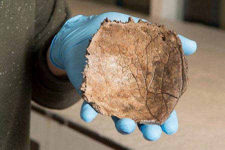
Saving the best for last, we have the ‘oldest dutchman’. A fragment of a left parietal bone (skull) dating back 13,000 years. This incredibly preserved item is the earliest form of modern human remains we have from Doggerland.
So, there we have it – 13,000 years ago humans were roaming freely between Norfolk and Amsterdam, and we can prove it thanks to those important finds that the sea has kindly given back. Next time in our third and final part in this series we will explore the scenic features of the Norfolk coast that have been left to us by the years of geological transformation since Doggerland’s disappearance.
Further reading:
Vincent Gaffney, Simon Fitch, and David Smith, Europe’s Lost World: The Rediscovery of Doggerland, CBA Research Report 160 (York: Council for British Archaeology, 2009).
Vincent Gaffney, Kenneth Thomson, and Simon Fitch, eds., Mapping Doggerland: The Mesolithic Landscapes of the Southern North Sea (Oxford: Archaeopress, 2007).
Luc Amkreutz and Sasja van der Vaart-Verschoof, eds., Doggerland: Lost World under the North Sea (Leiden: Sidestone Press, 2022).
Luc Amkreutz, Marcel Niekus, Dimitri Schiltmans, and Bjørn Smit, “Beyond Bycatch: The Prehistoric Archaeology of Doggerland,” Staringia 17, no. 1 (2022): 167–187.
Sascha Krüger, Walter Dörfler, Ole Bennike, and Steffen Wolters, “Life in Doggerland – Palynological Investigations of the Environmental Development of the North Sea Basin,” E&G Quaternary Science Journal 66, no. 1 (2017): 3–13.
James Walker, Vincent Gaffney, Simon Fitch, and Andy Fraser, “Doggerland,” in The Oxford Handbook of Mesolithic Europe, ed. by (editor name), (Oxford: Oxford University Press, 2025).
Written by C. James McPherson MA MSc.
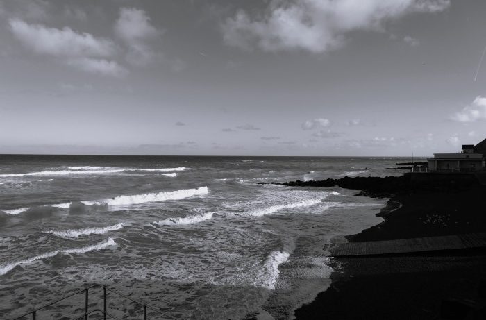
Cover image: GBC – March 2026
Part 1: Doggerland: Part One – Understanding the Land Below the Waves
Part 3: Doggerland: Part Three – Norfolk Now – Great British Coast