
From the time of Doggerland’s emergence from the ice rising see levels had already begun to claim some of the low-lying areas of this marshland. As the years rolled on and waters rose repeatedly the Mesolithic humans naturally migrated to the regions Highlands, such as Dogger Bank. A sand bank well known to modern day mariners for its proximity to the present water’s surface. Yet, soon every inch of the once luscious land bridge would be gone. So, what caused its complete disappearance?
Some scientists believe we can pin the blame on the Storegga Slides. The Storegga Slides were a series of submarine landslides that occurred in the Norwegian Sea. The resulting tsunamis are often labelled as the prime suspect for the inundation of Doggerland’s remnants.
Whatever the final nail in the coffin 8,000 years ago, the map of Europe would have begun to look a little more familiar, Britain was an island and Norfolk had a coastline.
Walking in mammoth footsteps …
Norfolk’s coast is one of the most lauded in the country. Famed for its beauty and treasured for its archaeology. Four areas in particular demonstrate the best of what Doggerland’s geography has given us. Those are: The Deep History Coast, Hunstanton Cliffs, Blakeney Point and Holme Dunes.
The Deep History Coast, stretching between Weybourne and Cart Gap, is a dynamic North Sea shoreline of soft cliffs, wide beaches and shifting sands. Geographically, it is defined by rapid coastal erosion, which continually exposes fresh geological and archaeological material. Geologically, the cliffs contain internationally important Pleistocene deposits, including glacial tills and the Cromer Forest-bed Formation, preserving evidence of Ice Age climates, ancient river systems, and extinct fauna. These sediments record repeated advances and retreats of ice sheets over the last million years.
Archaeologically, the coast has yielded some of the earliest human evidence in northern Europe, including the 800,000-year-old footprints discovered at Happisburgh and numerous Lower Palaeolithic flint tools. Its prehistoric significance lies in demonstrating that early humans occupied high northern latitudes during fluctuating climates. During periods of low sea level, this coastline overlooked the plains and rivers of Doggerland, which connected Britain to continental Europe. As post-glacial seas rose, those landscapes were drowned, transforming Britain into an island. The Deep History Coast uniquely combines active geomorphology with deep-time human evidence, making it one of Europe’s most important archives of environmental and prehistoric change.
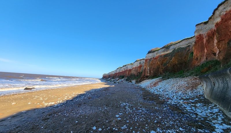
Hunstanton Cliffs form a distinctive west-facing coastline along The Wash, rising above sandy beaches and standing out in the otherwise low-lying Norfolk landscape. Their striking bands of white chalk, red chalk (Hunstanton Formation), and brown carstone reveal a clear sequence of Lower and Upper Cretaceous rocks deposited over 100 million years ago in warm, shallow seas. Though far older than the Ice Age deposits further east, the cliffs were later shaped by periglacial and marine processes.
Fossils such as ammonites and bivalves testify to their marine origins. Archaeologically, the immediate cliffs are less rich than the Deep History Coast, yet the surrounding area shows evidence of Mesolithic and later prehistoric activity linked to exploitation of coastal and estuarine resources. After Doggerland was inundated, communities adapted to newly formed shorelines such as this, using The Wash as a rich ecological zone for fishing and movement. Prehistoric significance here lies less in deep hominin antiquity and more in long-term human adaptation to coastal environments shaped by rising seas. Hunstanton’s geology provides a dramatic window into deep geological time, while its landscape reflects the environmental transformations that followed the end of the last Ice Age.
Blakeney Point is a four-mile shingle and sand spit projecting into the North Sea, sheltering saltmarshes and tidal creeks behind it. Geographically, it is a classic example of a barrier spit formed by longshore drift, with sediment transported westward from eroding cliffs. The landform is highly dynamic, migrating and reshaping under the influence of tides, storms and sea-level change. Geologically, it consists mainly of Holocene sands, silts and gravels accumulated over the last several thousand years, overlying older drowned landscapes. Beneath nearby marshes, peat layers record earlier terrestrial environments submerged as post-glacial sea levels rose. This broader marine transgression mirrors the flooding of Doggerland. Archaeologically, Blakeney Point itself is relatively recent, but the surrounding harbour supported medieval trade and earlier coastal use. Its prehistoric significance lies in illustrating how new coastal environments formed after the Ice Age, creating saltmarsh and estuarine habitats attractive to Mesolithic communities adapting to shrinking landmasses. Blakeney Point represents an evolving shoreline born from the same processes that reshaped north-west Europe at the end of the last glaciation.
Holme Dunes is a low-lying coastal landscape of sand dunes, saltmarsh and tidal flats on the north-west Norfolk coast. Its geography is defined by wind-blown dunes and tidal creeks that shift with storms and seasonal change. Geologically, the dunes are composed of Holocene sands overlying peat and older glacial sediments. These buried peat layers represent former freshwater marshes and woodlands drowned by rising seas after the last Ice Age, echoing the wider loss of Doggerland. Periodic storm erosion reveals these dark organic horizons on the foreshore. Archaeologically, Holme is renowned for “Seahenge,” a Bronze Age timber circle exposed in 1998, demonstrating how coastal change can reveal exceptionally preserved prehistoric structures. Flint tools and earlier evidence suggest Mesolithic activity in newly formed coastal habitats following post-glacial inundation. The prehistoric significance of Holme Dunes lies in its record of ritual activity, environmental transition and human adaptation to a transforming shoreline. It powerfully illustrates the long relationship between people and a coast continually reshaped by rising and falling seas.
In effect, Doggerland may be lost beneath the waves, but its story survives here. In Norfolk, the edge of England is also the edge of memory — where geology, archaeology and tide combine to remind us that coastlines are never fixed, and that today’s horizon was once someone else’s heartland.
Written by C. James McPherson MA MSc.
Cover photo: GBC – March 2026
Part 1: Doggerland: Part One – Understanding the Land Below the Waves – Great British Coast
Part 2: Doggerland: Part Two – What the Sea has Given Back – Great British Coast
Further reading:
Vincent Gaffney, Simon Fitch, and David Smith, Europe’s Lost World: The Rediscovery of Doggerland, CBA Research Report 160 (York: Council for British Archaeology, 2009).
Vincent Gaffney, Kenneth Thomson, and Simon Fitch, eds., Mapping Doggerland: The Mesolithic Landscapes of the Southern North Sea (Oxford: Archaeopress, 2007).
Luc Amkreutz and Sasja van der Vaart-Verschoof, eds., Doggerland: Lost World under the North Sea (Leiden: Sidestone Press, 2022).
Bryony Coles, “Doggerland: A Speculative Survey,” Proceedings of the Prehistoric Society 64 (1998): 45–81.
Bryony Coles, “The Doggerland Project: Exploring the Prehistoric Landscapes of the Southern North Sea,” Internet Archaeology 11 (2001).
James Walker et al., “A Great Wave: The Storegga Tsunami and the End of Doggerland?” Antiquity 94, no. 378 (2020): 1409–1425.
Vincent Gaffney et al., “Palaeolithic Footprints at Happisburgh, UK,” PLoS ONE 9, no. 4 (2014): e88329.
David Robertson et al., “Seahenge Revisited: Bronze Age Timber Circles at Holme-next-the-Sea,” Antiquity 73, no. 281 (1999): 392–402.
David Sear et al., “Holocene Sea-Level Change and the North Sea Basin,” Journal of Quaternary Science 26, no. 2 (2011): 115–129.
Peter Worsley, The Geology of the Hunstanton Area, Memoir for 1:50,000 Geological Sheet 129 (Nottingham: British Geological Survey, 1991).